Version 0.8.0 (15 November 2021)
Introducing CyberGISX 0.8.0
CyberGISX (https://cybergisxhub.cigi.illinois.edu/) is an open online platform that provides streamlined and user-friendly access to advanced cyberinfrastructure and cyberGIS capabilities with an integrated software stack for computationally reproducible and data-intensive geospatial analytics. Each user needs to register for a CyberGISX account to use the CyberGISX platform.
CyberGISX has been developed by a team led by Dr. Shaowen Wang within the CyberGIS Center for Advanced Digital and Spatial Studies (CyberGIS Center) & CyberInfrastructure and Geospatial Information Laboratory (CIGI Lab) at the University of Illinois Urbana-Champaign.
CyberGISX is built on more than a decade of leading-edge research on cyberGIS mainly supported by several U.S. federal agencies such as the National Science Foundation. It has been used in a variety of geospatial-related domains such as agriculture, geography, and spatial sciences, hydrology and water resources, and public health. Users from more than 4,000 universities, research institutes, and academic organizations in the US and worldwide can quickly register and start using CyberGISX with their institutional credentials.
This CyberGISX release includes the following four key components.
CyberGIS-Hub
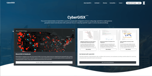
CyberGIS-Hub
CyberGIS-Hub is a user-centric community portal for discovering and sharing cyberGIS notebooks and related digital resources to enable computational and data-intensive research and education. It provides one-stop access to the CyberGISX platform. Users can quickly “single sign-on” and start accessing the Hub and other services in CyberGISX using their existing institutional credentials. The discovery page on the Hub allows searching for cyberGIS notebooks of interest by different types of metadata. With a simple click on the “Open With” button, any notebook discovered on the Hub can be launched in CyberGIS-Jupyter for a live run. Users can reproduce others’ work and build their own research on top of existing notebooks in this integrated “Sharing & Computing” environment without downloading or installing anything locally. Once a new notebook is developed on CyberGIS-Jupyter, it can be registered on the Hub and shared with other users. In addition to notebooks, users can publish blogs to further disseminate research outcomes. The Hub also provides a publicly shareable professional profile page to highlight users’ contributions to the community. The Knowledge Base page on the Hub is a good place to learn and discover more advanced features CyberGISX provides.
Key Features
- Use your institutional credentials: quickly log in and start using CyberGIS-Hub with your institutional credentials (powered by CILogon). Supported identity providers include more than 4,000 universities, research institutes, and academic organizations in the US and worldwide.
- Discovery of cyberGIS-enabled notebooks: search and discover various geospatial notebooks created and shared by other users.
- Run notebooks live to reproduce published work: any notebook discovered on CyberGIS-Hub can be executed live in the CyberGIS-Jupyter environment through a simple click on the “open with” button.
- Share your notebooks and blogs: you can share your notebooks with others, and write up blogs to further disseminate your research.
- Build a professional profile: take advantage of a publicly shareable, professional profile page that highlights the notebooks and blogs you have contributed.
- Online knowledge base: regularly published and updated documents and tutorials allowing you to discover CyberGISX functionalities in a flexible and self-paced fashion.
- Help CyberGISX improve: an online form is available to all users for bug reports, feature requests, and any questions/suggestions related to CyberGISX.
CyberGIS-Jupyter
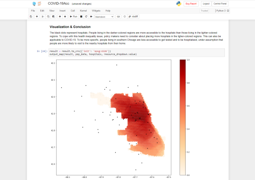
CyberGIS-Jupyter
CyberGIS-Jupyter is an online science gateway environment for users to conduct and share reproducible Jupyter Notebooks focused on scalable geospatial data processing and cyberGIS analytics. CyberGIS-Jupyter integrates many cyberGIS and geospatial libraries and is supported by advanced cyberinfrastructure resources.
Key Features
-
Software Management: Our new release utilizes Lmod to manage software. Lmod supports automatic software loading when you launch your kernel and keeps multiple versions of software on CyberGISX simultaneously. Any current workflows with hard-coded paths to software may need to be updated.
- New Kernels: We are alpha testing three new kernels:
- Script of Scripts (SoS) Kernel. This kernel allows users to develop multi-language notebooks.
- SSH Kernel. This kernel is designed to aid users in executing commands remotely using SSH.
- R Kernel. This kernel is designed to allow users to develop notebooks with the R programming language.
- Versioned kernels: In addition to the common kernels, this release supports versioned kernels that will not change over releases. Our expectation is that this feature will increase reproducibility while allowing seamless software updating for each release. Users can see the “Python 3-0.8.0” versioned kernel in the dropdown and other versioned kernels should be available through the ‘cybergisx’ command-line interface.
- The ‘cybergisx’ CLI: This feature helps users manage which versioned kernels they would like to use so that CyberGIS-Jupyter can avoid listing every version of every kernel in the dropdown. Users can see the options using “!cybergisx -h’ in a notebook or “cybergisx -h” in the terminal.
CyberGIS-Compute
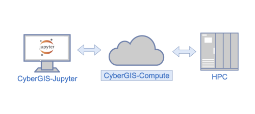
CyberGIS-Compute components
CyberGIS-Compute is an open-sourced geospatial middleware framework that provides integrated access to high-performance computing (HPC) resources through a Python-based SDK and core middleware services. The key components of CyberGIS-Compute include CyberGIS-Compute SDK and CyberGIS-Compute Core. CyberGIS-Compute is released under Apache 2.0 license.
Key Features
- Seamless submission of workflows to HPC resources.
- Support for large file transfers needed for HPC workflows through Globus.
- Community model contribution via GitHub enabled.
- SDK interface simplified for better user experience.
- SDK adds support for HPC job submission via a user interface.
- Enabled fine granularity control in settings for Slurm-based HPC workflows.
- A user-centric system for job management.
CyberGIS-Vis
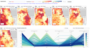
CyberGIS-Vis
CyberGIS-Vis integrates cutting-edge cyberGIS and online visualization capabilities into a suite of dynamically configurable software modules for visualization and visual analytical approaches to knowledge discovery based on high-dimensional geospatial data. CyberGIS-Vis is open-sourced under Apache 2.0.
Key Features
- Comparative visualization of spatiotemporal patterns through choropleth maps.
- Dynamic cartographic mapping linked with charts to explore high-dimensional and spatiotemporal data.
- Reproducible visual analytics through integration with CyberGIS-Jupyter.
- Multi-language support including Javascript and Python.
How to report bugs or issues?
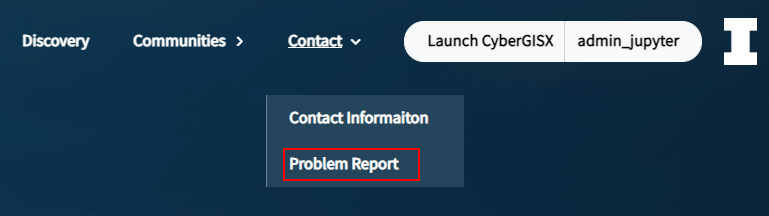
Option 1: Go to CyberGIS-Hub website at https://cybergisxhub.cigi.illinois.edu/ –> Contact -> Problem Report;
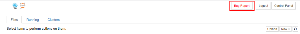
Option 2: Click on the “Bug Report” button (upper right corner) in CyberGIS-Jupyter environment (will open the Problem Report page on CyberGIS-Hub as above);
Option 3: Email to help@cybergis.org
