RHESSys (Regional Hydro-Ecological Simulation System) is a GIS-based, terrestrial ecohydrologic modeling framework designed to simulate carbon, water and nutrient fluxes at the watershed scale. RHESSys models the temporal and spatial variability of ecosystem processes and interactions at a daily time step over multiple years by combining a set of physically based process models and a methodology for partitioning and parameterizing the landscape. Detailed model algorithms are available in Tague and Band (2004).
This notebook demonstrates parallel job submissions of RHESSys ensemble simulations from CyberGIS-Jupyer for water to HPC (XSEDE), visualizes RHESSys output, and evaluate RHESSys efficiency with simulation runoff and observation streamflow.
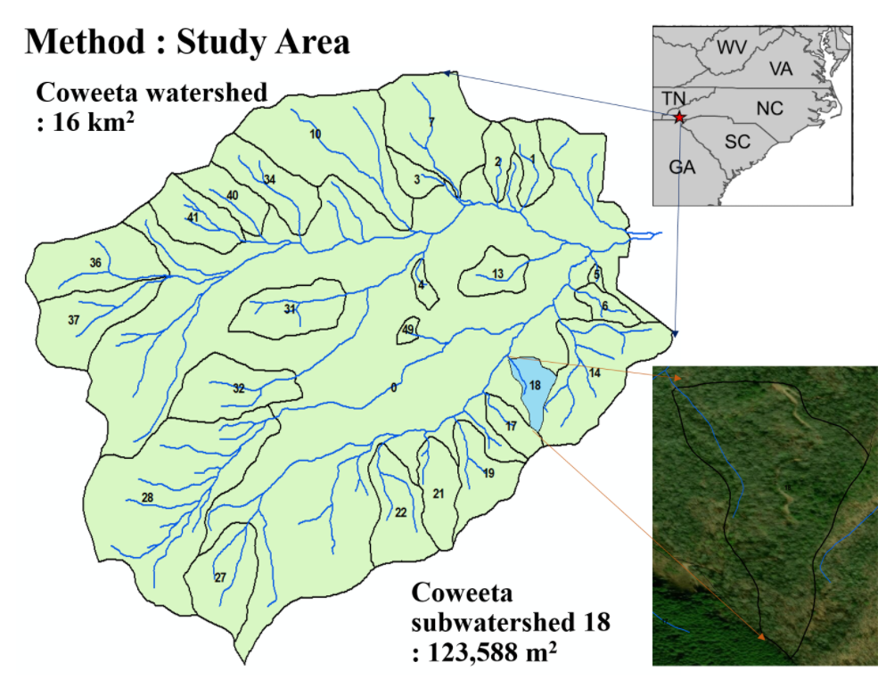
The Coweeta Long Term Ecological Research (LTER) Program is based on a collaborative agreement between the University of Georgia Research Foundation in Athens, Georgia, and the USDA Forest Service Coweeta Hydrologic Laboratory in Macon County, North Carolina. This study area is Coweeta subbasin 18 where is the one of the subbasin in Coweeta watershed. (Coweeta: 16 km2, subbasin18: 0.124km2)
import tempfile
import shutil, os
workspace_dir = os.path.join(os.getcwd(), 'workspace')
proj_folder_name = "CoweetaSub18_30m"
!mkdir -p {workspace_dir}
unzip_dir = tempfile.mkdtemp(dir=workspace_dir)
proj_folder = os.path.join(unzip_dir, proj_folder_name)
model_folder = os.path.join(unzip_dir, proj_folder_name, "model")
!mkdir -p {model_folder}
!unzip -o {proj_folder_name}.zip -d {model_folder}
shutil.rmtree(os.path.join(model_folder, "RHESSysEastCoast"))
Archive:  CoweetaSub18_30m.zip
   creating: /home/jovyan/work/Downloads/42876f9b26be46969d797a060b914782/42876f9b26be46969d797a060b914782/data/contents/workspace/tmp6iz2dtom/CoweetaSub18_30m/model/clim/
  inflating: /home/jovyan/work/Downloads/42876f9b26be46969d797a060b914782/42876f9b26be46969d797a060b914782/data/contents/workspace/tmp6iz2dtom/CoweetaSub18_30m/model/clim/cwt.base
  inflating: /home/jovyan/work/Downloads/42876f9b26be46969d797a060b914782/42876f9b26be46969d797a060b914782/data/contents/workspace/tmp6iz2dtom/CoweetaSub18_30m/model/clim/cwt.rain
  inflating: /home/jovyan/work/Downloads/42876f9b26be46969d797a060b914782/42876f9b26be46969d797a060b914782/data/contents/workspace/tmp6iz2dtom/CoweetaSub18_30m/model/clim/cwt.tmax
  inflating: /home/jovyan/work/Downloads/42876f9b26be46969d797a060b914782/42876f9b26be46969d797a060b914782/data/contents/workspace/tmp6iz2dtom/CoweetaSub18_30m/model/clim/cwt.tmin
   creating: /home/jovyan/work/Downloads/42876f9b26be46969d797a060b914782/42876f9b26be46969d797a060b914782/data/contents/workspace/tmp6iz2dtom/CoweetaSub18_30m/model/defs/
 extracting: /home/jovyan/work/Downloads/42876f9b26be46969d797a060b914782/42876f9b26be46969d797a060b914782/data/contents/workspace/tmp6iz2dtom/CoweetaSub18_30m/model/defs/basin_basin.def
  inflating: /home/jovyan/work/Downloads/42876f9b26be46969d797a060b914782/42876f9b26be46969d797a060b914782/data/contents/workspace/tmp6iz2dtom/CoweetaSub18_30m/model/defs/hill_setting1.def
  inflating: /home/jovyan/work/Downloads/42876f9b26be46969d797a060b914782/42876f9b26be46969d797a060b914782/data/contents/workspace/tmp6iz2dtom/CoweetaSub18_30m/model/defs/landuse_setting1.def
  inflating: /home/jovyan/work/Downloads/42876f9b26be46969d797a060b914782/42876f9b26be46969d797a060b914782/data/contents/workspace/tmp6iz2dtom/CoweetaSub18_30m/model/defs/soil_loam_9.def
  inflating: /home/jovyan/work/Downloads/42876f9b26be46969d797a060b914782/42876f9b26be46969d797a060b914782/data/contents/workspace/tmp6iz2dtom/CoweetaSub18_30m/model/defs/soil_sandy_loam_12.def
  inflating: /home/jovyan/work/Downloads/42876f9b26be46969d797a060b914782/42876f9b26be46969d797a060b914782/data/contents/workspace/tmp6iz2dtom/CoweetaSub18_30m/model/defs/stratum_deciduous.def
  inflating: /home/jovyan/work/Downloads/42876f9b26be46969d797a060b914782/42876f9b26be46969d797a060b914782/data/contents/workspace/tmp6iz2dtom/CoweetaSub18_30m/model/defs/stratum_evergreen.def
  inflating: /home/jovyan/work/Downloads/42876f9b26be46969d797a060b914782/42876f9b26be46969d797a060b914782/data/contents/workspace/tmp6iz2dtom/CoweetaSub18_30m/model/defs/zone_setting1.def
   creating: /home/jovyan/work/Downloads/42876f9b26be46969d797a060b914782/42876f9b26be46969d797a060b914782/data/contents/workspace/tmp6iz2dtom/CoweetaSub18_30m/model/flows/
  inflating: /home/jovyan/work/Downloads/42876f9b26be46969d797a060b914782/42876f9b26be46969d797a060b914782/data/contents/workspace/tmp6iz2dtom/CoweetaSub18_30m/model/flows/subflow.txt
  inflating: /home/jovyan/work/Downloads/42876f9b26be46969d797a060b914782/42876f9b26be46969d797a060b914782/data/contents/workspace/tmp6iz2dtom/CoweetaSub18_30m/model/flows/surfflow.txt
  inflating: /home/jovyan/work/Downloads/42876f9b26be46969d797a060b914782/42876f9b26be46969d797a060b914782/data/contents/workspace/tmp6iz2dtom/CoweetaSub18_30m/model/lulcFrac10m.csv
   creating: /home/jovyan/work/Downloads/42876f9b26be46969d797a060b914782/42876f9b26be46969d797a060b914782/data/contents/workspace/tmp6iz2dtom/CoweetaSub18_30m/model/obs/
  inflating: /home/jovyan/work/Downloads/42876f9b26be46969d797a060b914782/42876f9b26be46969d797a060b914782/data/contents/workspace/tmp6iz2dtom/CoweetaSub18_30m/model/obs/climate_coweeta_ws18.csv
  inflating: /home/jovyan/work/Downloads/42876f9b26be46969d797a060b914782/42876f9b26be46969d797a060b914782/data/contents/workspace/tmp6iz2dtom/CoweetaSub18_30m/model/obs/streamflow_coweeta_ws18.csv
   creating: /home/jovyan/work/Downloads/42876f9b26be46969d797a060b914782/42876f9b26be46969d797a060b914782/data/contents/workspace/tmp6iz2dtom/CoweetaSub18_30m/model/output/
  inflating: /home/jovyan/work/Downloads/42876f9b26be46969d797a060b914782/42876f9b26be46969d797a060b914782/data/contents/workspace/tmp6iz2dtom/CoweetaSub18_30m/model/output/++s1=0.9++s3=1.5++_basin.daily
  inflating: /home/jovyan/work/Downloads/42876f9b26be46969d797a060b914782/42876f9b26be46969d797a060b914782/data/contents/workspace/tmp6iz2dtom/CoweetaSub18_30m/model/output/++s1=0.9++s3=1.5++_basin.hourly
  inflating: /home/jovyan/work/Downloads/42876f9b26be46969d797a060b914782/42876f9b26be46969d797a060b914782/data/contents/workspace/tmp6iz2dtom/CoweetaSub18_30m/model/output/++s1=0.9++s3=1.5++_basin.monthly
  inflating: /home/jovyan/work/Downloads/42876f9b26be46969d797a060b914782/42876f9b26be46969d797a060b914782/data/contents/workspace/tmp6iz2dtom/CoweetaSub18_30m/model/output/++s1=0.9++s3=1.5++_basin.yearly
  inflating: /home/jovyan/work/Downloads/42876f9b26be46969d797a060b914782/42876f9b26be46969d797a060b914782/data/contents/workspace/tmp6iz2dtom/CoweetaSub18_30m/model/output/++s1=0.9++s3=1.5++_hill_setting1_hillslope.params
  inflating: /home/jovyan/work/Downloads/42876f9b26be46969d797a060b914782/42876f9b26be46969d797a060b914782/data/contents/workspace/tmp6iz2dtom/CoweetaSub18_30m/model/output/++s1=0.9++s3=1.5++_landuse_setting1_landuse.params
  inflating: /home/jovyan/work/Downloads/42876f9b26be46969d797a060b914782/42876f9b26be46969d797a060b914782/data/contents/workspace/tmp6iz2dtom/CoweetaSub18_30m/model/output/++s1=0.9++s3=1.5++_stratum_deciduous_stratum.params
  inflating: /home/jovyan/work/Downloads/42876f9b26be46969d797a060b914782/42876f9b26be46969d797a060b914782/data/contents/workspace/tmp6iz2dtom/CoweetaSub18_30m/model/output/++s1=0.9++s3=1.5++_stratum_evergreen_stratum.params
  inflating: /home/jovyan/work/Downloads/42876f9b26be46969d797a060b914782/42876f9b26be46969d797a060b914782/data/contents/workspace/tmp6iz2dtom/CoweetaSub18_30m/model/output/++s1=0.9++s3=1.5++_zone_setting1_zone.params
  inflating: /home/jovyan/work/Downloads/42876f9b26be46969d797a060b914782/42876f9b26be46969d797a060b914782/data/contents/workspace/tmp6iz2dtom/CoweetaSub18_30m/model/output/++s1=0.9++s3=1.55++_basin.daily
  inflating: /home/jovyan/work/Downloads/42876f9b26be46969d797a060b914782/42876f9b26be46969d797a060b914782/data/contents/workspace/tmp6iz2dtom/CoweetaSub18_30m/model/output/++s1=0.9++s3=1.55++_basin.hourly
  inflating: /home/jovyan/work/Downloads/42876f9b26be46969d797a060b914782/42876f9b26be46969d797a060b914782/data/contents/workspace/tmp6iz2dtom/CoweetaSub18_30m/model/output/++s1=0.9++s3=1.55++_basin.monthly
  inflating: /home/jovyan/work/Downloads/42876f9b26be46969d797a060b914782/42876f9b26be46969d797a060b914782/data/contents/workspace/tmp6iz2dtom/CoweetaSub18_30m/model/output/++s1=0.9++s3=1.55++_basin.yearly
  inflating: /home/jovyan/work/Downloads/42876f9b26be46969d797a060b914782/42876f9b26be46969d797a060b914782/data/contents/workspace/tmp6iz2dtom/CoweetaSub18_30m/model/output/++s1=0.9++s3=1.55++_hill_setting1_hillslope.params
  inflating: /home/jovyan/work/Downloads/42876f9b26be46969d797a060b914782/42876f9b26be46969d797a060b914782/data/contents/workspace/tmp6iz2dtom/CoweetaSub18_30m/model/output/++s1=0.9++s3=1.55++_landuse_setting1_landuse.params
  inflating: /home/jovyan/work/Downloads/42876f9b26be46969d797a060b914782/42876f9b26be46969d797a060b914782/data/contents/workspace/tmp6iz2dtom/CoweetaSub18_30m/model/output/++s1=0.9++s3=1.55++_stratum_deciduous_stratum.params
  inflating: /home/jovyan/work/Downloads/42876f9b26be46969d797a060b914782/42876f9b26be46969d797a060b914782/data/contents/workspace/tmp6iz2dtom/CoweetaSub18_30m/model/output/++s1=0.9++s3=1.55++_stratum_evergreen_stratum.params
  inflating: /home/jovyan/work/Downloads/42876f9b26be46969d797a060b914782/42876f9b26be46969d797a060b914782/data/contents/workspace/tmp6iz2dtom/CoweetaSub18_30m/model/output/++s1=0.9++s3=1.55++_zone_setting1_zone.params
  inflating: /home/jovyan/work/Downloads/42876f9b26be46969d797a060b914782/42876f9b26be46969d797a060b914782/data/contents/workspace/tmp6iz2dtom/CoweetaSub18_30m/model/output/++s1=0.9++s3=1.6++_basin.daily
  inflating: /home/jovyan/work/Downloads/42876f9b26be46969d797a060b914782/42876f9b26be46969d797a060b914782/data/contents/workspace/tmp6iz2dtom/CoweetaSub18_30m/model/output/++s1=0.9++s3=1.6++_basin.hourly
  inflating: /home/jovyan/work/Downloads/42876f9b26be46969d797a060b914782/42876f9b26be46969d797a060b914782/data/contents/workspace/tmp6iz2dtom/CoweetaSub18_30m/model/output/++s1=0.9++s3=1.6++_basin.monthly
  inflating: /home/jovyan/work/Downloads/42876f9b26be46969d797a060b914782/42876f9b26be46969d797a060b914782/data/contents/workspace/tmp6iz2dtom/CoweetaSub18_30m/model/output/++s1=0.9++s3=1.6++_basin.yearly
  inflating: /home/jovyan/work/Downloads/42876f9b26be46969d797a060b914782/42876f9b26be46969d797a060b914782/data/contents/workspace/tmp6iz2dtom/CoweetaSub18_30m/model/output/++s1=0.9++s3=1.6++_hill_setting1_hillslope.params
  inflating: /home/jovyan/work/Downloads/42876f9b26be46969d797a060b914782/42876f9b26be46969d797a060b914782/data/contents/workspace/tmp6iz2dtom/CoweetaSub18_30m/model/output/++s1=0.9++s3=1.6++_landuse_setting1_landuse.params
  inflating: /home/jovyan/work/Downloads/42876f9b26be46969d797a060b914782/42876f9b26be46969d797a060b914782/data/contents/workspace/tmp6iz2dtom/CoweetaSub18_30m/model/output/++s1=0.9++s3=1.6++_stratum_deciduous_stratum.params
  inflating: /home/jovyan/work/Downloads/42876f9b26be46969d797a060b914782/42876f9b26be46969d797a060b914782/data/contents/workspace/tmp6iz2dtom/CoweetaSub18_30m/model/output/++s1=0.9++s3=1.6++_stratum_evergreen_stratum.params
  inflating: /home/jovyan/work/Downloads/42876f9b26be46969d797a060b914782/42876f9b26be46969d797a060b914782/data/contents/workspace/tmp6iz2dtom/CoweetaSub18_30m/model/output/++s1=0.9++s3=1.6++_zone_setting1_zone.params
  inflating: /home/jovyan/work/Downloads/42876f9b26be46969d797a060b914782/42876f9b26be46969d797a060b914782/data/contents/workspace/tmp6iz2dtom/CoweetaSub18_30m/model/output/++s1=0.9++s3=1.65++_basin.daily
  inflating: /home/jovyan/work/Downloads/42876f9b26be46969d797a060b914782/42876f9b26be46969d797a060b914782/data/contents/workspace/tmp6iz2dtom/CoweetaSub18_30m/model/output/++s1=0.9++s3=1.65++_basin.hourly
  inflating: /home/jovyan/work/Downloads/42876f9b26be46969d797a060b914782/42876f9b26be46969d797a060b914782/data/contents/workspace/tmp6iz2dtom/CoweetaSub18_30m/model/output/++s1=0.9++s3=1.65++_basin.monthly
  inflating: /home/jovyan/work/Downloads/42876f9b26be46969d797a060b914782/42876f9b26be46969d797a060b914782/data/contents/workspace/tmp6iz2dtom/CoweetaSub18_30m/model/output/++s1=0.9++s3=1.65++_basin.yearly
  inflating: /home/jovyan/work/Downloads/42876f9b26be46969d797a060b914782/42876f9b26be46969d797a060b914782/data/contents/workspace/tmp6iz2dtom/CoweetaSub18_30m/model/output/++s1=0.9++s3=1.65++_hill_setting1_hillslope.params
  inflating: /home/jovyan/work/Downloads/42876f9b26be46969d797a060b914782/42876f9b26be46969d797a060b914782/data/contents/workspace/tmp6iz2dtom/CoweetaSub18_30m/model/output/++s1=0.9++s3=1.65++_landuse_setting1_landuse.params
  inflating: /home/jovyan/work/Downloads/42876f9b26be46969d797a060b914782/42876f9b26be46969d797a060b914782/data/contents/workspace/tmp6iz2dtom/CoweetaSub18_30m/model/output/++s1=0.9++s3=1.65++_stratum_deciduous_stratum.params
  inflating: /home/jovyan/work/Downloads/42876f9b26be46969d797a060b914782/42876f9b26be46969d797a060b914782/data/contents/workspace/tmp6iz2dtom/CoweetaSub18_30m/model/output/++s1=0.9++s3=1.65++_stratum_evergreen_stratum.params
  inflating: /home/jovyan/work/Downloads/42876f9b26be46969d797a060b914782/42876f9b26be46969d797a060b914782/data/contents/workspace/tmp6iz2dtom/CoweetaSub18_30m/model/output/++s1=0.9++s3=1.65++_zone_setting1_zone.params
  inflating: /home/jovyan/work/Downloads/42876f9b26be46969d797a060b914782/42876f9b26be46969d797a060b914782/data/contents/workspace/tmp6iz2dtom/CoweetaSub18_30m/model/output/++s1=1.0++s3=1.5++_basin.daily
  inflating: /home/jovyan/work/Downloads/42876f9b26be46969d797a060b914782/42876f9b26be46969d797a060b914782/data/contents/workspace/tmp6iz2dtom/CoweetaSub18_30m/model/output/++s1=1.0++s3=1.5++_basin.hourly
  inflating: /home/jovyan/work/Downloads/42876f9b26be46969d797a060b914782/42876f9b26be46969d797a060b914782/data/contents/workspace/tmp6iz2dtom/CoweetaSub18_30m/model/output/++s1=1.0++s3=1.5++_basin.monthly
  inflating: /home/jovyan/work/Downloads/42876f9b26be46969d797a060b914782/42876f9b26be46969d797a060b914782/data/contents/workspace/tmp6iz2dtom/CoweetaSub18_30m/model/output/++s1=1.0++s3=1.5++_basin.yearly
  inflating: /home/jovyan/work/Downloads/42876f9b26be46969d797a060b914782/42876f9b26be46969d797a060b914782/data/contents/workspace/tmp6iz2dtom/CoweetaSub18_30m/model/output/++s1=1.0++s3=1.5++_hill_setting1_hillslope.params
  inflating: /home/jovyan/work/Downloads/42876f9b26be46969d797a060b914782/42876f9b26be46969d797a060b914782/data/contents/workspace/tmp6iz2dtom/CoweetaSub18_30m/model/output/++s1=1.0++s3=1.5++_landuse_setting1_landuse.params
  inflating: /home/jovyan/work/Downloads/42876f9b26be46969d797a060b914782/42876f9b26be46969d797a060b914782/data/contents/workspace/tmp6iz2dtom/CoweetaSub18_30m/model/output/++s1=1.0++s3=1.5++_stratum_deciduous_stratum.params
  inflating: /home/jovyan/work/Downloads/42876f9b26be46969d797a060b914782/42876f9b26be46969d797a060b914782/data/contents/workspace/tmp6iz2dtom/CoweetaSub18_30m/model/output/++s1=1.0++s3=1.5++_stratum_evergreen_stratum.params
  inflating: /home/jovyan/work/Downloads/42876f9b26be46969d797a060b914782/42876f9b26be46969d797a060b914782/data/contents/workspace/tmp6iz2dtom/CoweetaSub18_30m/model/output/++s1=1.0++s3=1.5++_zone_setting1_zone.params
  inflating: /home/jovyan/work/Downloads/42876f9b26be46969d797a060b914782/42876f9b26be46969d797a060b914782/data/contents/workspace/tmp6iz2dtom/CoweetaSub18_30m/model/output/++s1=1.0++s3=1.55++_basin.daily
  inflating: /home/jovyan/work/Downloads/42876f9b26be46969d797a060b914782/42876f9b26be46969d797a060b914782/data/contents/workspace/tmp6iz2dtom/CoweetaSub18_30m/model/output/++s1=1.0++s3=1.55++_basin.hourly
  inflating: /home/jovyan/work/Downloads/42876f9b26be46969d797a060b914782/42876f9b26be46969d797a060b914782/data/contents/workspace/tmp6iz2dtom/CoweetaSub18_30m/model/output/++s1=1.0++s3=1.55++_basin.monthly
  inflating: /home/jovyan/work/Downloads/42876f9b26be46969d797a060b914782/42876f9b26be46969d797a060b914782/data/contents/workspace/tmp6iz2dtom/CoweetaSub18_30m/model/output/++s1=1.0++s3=1.55++_basin.yearly
  inflating: /home/jovyan/work/Downloads/42876f9b26be46969d797a060b914782/42876f9b26be46969d797a060b914782/data/contents/workspace/tmp6iz2dtom/CoweetaSub18_30m/model/output/++s1=1.0++s3=1.55++_hill_setting1_hillslope.params
  inflating: /home/jovyan/work/Downloads/42876f9b26be46969d797a060b914782/42876f9b26be46969d797a060b914782/data/contents/workspace/tmp6iz2dtom/CoweetaSub18_30m/model/output/++s1=1.0++s3=1.55++_landuse_setting1_landuse.params
  inflating: /home/jovyan/work/Downloads/42876f9b26be46969d797a060b914782/42876f9b26be46969d797a060b914782/data/contents/workspace/tmp6iz2dtom/CoweetaSub18_30m/model/output/++s1=1.0++s3=1.55++_stratum_deciduous_stratum.params
  inflating: /home/jovyan/work/Downloads/42876f9b26be46969d797a060b914782/42876f9b26be46969d797a060b914782/data/contents/workspace/tmp6iz2dtom/CoweetaSub18_30m/model/output/++s1=1.0++s3=1.55++_stratum_evergreen_stratum.params
  inflating: /home/jovyan/work/Downloads/42876f9b26be46969d797a060b914782/42876f9b26be46969d797a060b914782/data/contents/workspace/tmp6iz2dtom/CoweetaSub18_30m/model/output/++s1=1.0++s3=1.55++_zone_setting1_zone.params
  inflating: /home/jovyan/work/Downloads/42876f9b26be46969d797a060b914782/42876f9b26be46969d797a060b914782/data/contents/workspace/tmp6iz2dtom/CoweetaSub18_30m/model/output/++s1=1.0++s3=1.6++_basin.daily
  inflating: /home/jovyan/work/Downloads/42876f9b26be46969d797a060b914782/42876f9b26be46969d797a060b914782/data/contents/workspace/tmp6iz2dtom/CoweetaSub18_30m/model/output/++s1=1.0++s3=1.6++_basin.hourly
  inflating: /home/jovyan/work/Downloads/42876f9b26be46969d797a060b914782/42876f9b26be46969d797a060b914782/data/contents/workspace/tmp6iz2dtom/CoweetaSub18_30m/model/output/++s1=1.0++s3=1.6++_basin.monthly
  inflating: /home/jovyan/work/Downloads/42876f9b26be46969d797a060b914782/42876f9b26be46969d797a060b914782/data/contents/workspace/tmp6iz2dtom/CoweetaSub18_30m/model/output/++s1=1.0++s3=1.6++_basin.yearly
  inflating: /home/jovyan/work/Downloads/42876f9b26be46969d797a060b914782/42876f9b26be46969d797a060b914782/data/contents/workspace/tmp6iz2dtom/CoweetaSub18_30m/model/output/++s1=1.0++s3=1.6++_hill_setting1_hillslope.params
  inflating: /home/jovyan/work/Downloads/42876f9b26be46969d797a060b914782/42876f9b26be46969d797a060b914782/data/contents/workspace/tmp6iz2dtom/CoweetaSub18_30m/model/output/++s1=1.0++s3=1.6++_landuse_setting1_landuse.params
  inflating: /home/jovyan/work/Downloads/42876f9b26be46969d797a060b914782/42876f9b26be46969d797a060b914782/data/contents/workspace/tmp6iz2dtom/CoweetaSub18_30m/model/output/++s1=1.0++s3=1.6++_stratum_deciduous_stratum.params
  inflating: /home/jovyan/work/Downloads/42876f9b26be46969d797a060b914782/42876f9b26be46969d797a060b914782/data/contents/workspace/tmp6iz2dtom/CoweetaSub18_30m/model/output/++s1=1.0++s3=1.6++_stratum_evergreen_stratum.params
  inflating: /home/jovyan/work/Downloads/42876f9b26be46969d797a060b914782/42876f9b26be46969d797a060b914782/data/contents/workspace/tmp6iz2dtom/CoweetaSub18_30m/model/output/++s1=1.0++s3=1.6++_zone_setting1_zone.params
  inflating: /home/jovyan/work/Downloads/42876f9b26be46969d797a060b914782/42876f9b26be46969d797a060b914782/data/contents/workspace/tmp6iz2dtom/CoweetaSub18_30m/model/output/++s1=1.0++s3=1.65++_basin.daily
  inflating: /home/jovyan/work/Downloads/42876f9b26be46969d797a060b914782/42876f9b26be46969d797a060b914782/data/contents/workspace/tmp6iz2dtom/CoweetaSub18_30m/model/output/++s1=1.0++s3=1.65++_basin.hourly
  inflating: /home/jovyan/work/Downloads/42876f9b26be46969d797a060b914782/42876f9b26be46969d797a060b914782/data/contents/workspace/tmp6iz2dtom/CoweetaSub18_30m/model/output/++s1=1.0++s3=1.65++_basin.monthly
  inflating: /home/jovyan/work/Downloads/42876f9b26be46969d797a060b914782/42876f9b26be46969d797a060b914782/data/contents/workspace/tmp6iz2dtom/CoweetaSub18_30m/model/output/++s1=1.0++s3=1.65++_basin.yearly
  inflating: /home/jovyan/work/Downloads/42876f9b26be46969d797a060b914782/42876f9b26be46969d797a060b914782/data/contents/workspace/tmp6iz2dtom/CoweetaSub18_30m/model/output/++s1=1.0++s3=1.65++_hill_setting1_hillslope.params
  inflating: /home/jovyan/work/Downloads/42876f9b26be46969d797a060b914782/42876f9b26be46969d797a060b914782/data/contents/workspace/tmp6iz2dtom/CoweetaSub18_30m/model/output/++s1=1.0++s3=1.65++_landuse_setting1_landuse.params
  inflating: /home/jovyan/work/Downloads/42876f9b26be46969d797a060b914782/42876f9b26be46969d797a060b914782/data/contents/workspace/tmp6iz2dtom/CoweetaSub18_30m/model/output/++s1=1.0++s3=1.65++_stratum_deciduous_stratum.params
  inflating: /home/jovyan/work/Downloads/42876f9b26be46969d797a060b914782/42876f9b26be46969d797a060b914782/data/contents/workspace/tmp6iz2dtom/CoweetaSub18_30m/model/output/++s1=1.0++s3=1.65++_stratum_evergreen_stratum.params
  inflating: /home/jovyan/work/Downloads/42876f9b26be46969d797a060b914782/42876f9b26be46969d797a060b914782/data/contents/workspace/tmp6iz2dtom/CoweetaSub18_30m/model/output/++s1=1.0++s3=1.65++_zone_setting1_zone.params
  inflating: /home/jovyan/work/Downloads/42876f9b26be46969d797a060b914782/42876f9b26be46969d797a060b914782/data/contents/workspace/tmp6iz2dtom/CoweetaSub18_30m/model/output/++s1=1.1++s3=1.5++_basin.daily
  inflating: /home/jovyan/work/Downloads/42876f9b26be46969d797a060b914782/42876f9b26be46969d797a060b914782/data/contents/workspace/tmp6iz2dtom/CoweetaSub18_30m/model/output/++s1=1.1++s3=1.5++_basin.hourly
  inflating: /home/jovyan/work/Downloads/42876f9b26be46969d797a060b914782/42876f9b26be46969d797a060b914782/data/contents/workspace/tmp6iz2dtom/CoweetaSub18_30m/model/output/++s1=1.1++s3=1.5++_basin.monthly
  inflating: /home/jovyan/work/Downloads/42876f9b26be46969d797a060b914782/42876f9b26be46969d797a060b914782/data/contents/workspace/tmp6iz2dtom/CoweetaSub18_30m/model/output/++s1=1.1++s3=1.5++_basin.yearly
  inflating: /home/jovyan/work/Downloads/42876f9b26be46969d797a060b914782/42876f9b26be46969d797a060b914782/data/contents/workspace/tmp6iz2dtom/CoweetaSub18_30m/model/output/++s1=1.1++s3=1.5++_hill_setting1_hillslope.params
  inflating: /home/jovyan/work/Downloads/42876f9b26be46969d797a060b914782/42876f9b26be46969d797a060b914782/data/contents/workspace/tmp6iz2dtom/CoweetaSub18_30m/model/output/++s1=1.1++s3=1.5++_landuse_setting1_landuse.params
  inflating: /home/jovyan/work/Downloads/42876f9b26be46969d797a060b914782/42876f9b26be46969d797a060b914782/data/contents/workspace/tmp6iz2dtom/CoweetaSub18_30m/model/output/++s1=1.1++s3=1.5++_stratum_deciduous_stratum.params
  inflating: /home/jovyan/work/Downloads/42876f9b26be46969d797a060b914782/42876f9b26be46969d797a060b914782/data/contents/workspace/tmp6iz2dtom/CoweetaSub18_30m/model/output/++s1=1.1++s3=1.5++_stratum_evergreen_stratum.params
  inflating: /home/jovyan/work/Downloads/42876f9b26be46969d797a060b914782/42876f9b26be46969d797a060b914782/data/contents/workspace/tmp6iz2dtom/CoweetaSub18_30m/model/output/++s1=1.1++s3=1.5++_zone_setting1_zone.params
  inflating: /home/jovyan/work/Downloads/42876f9b26be46969d797a060b914782/42876f9b26be46969d797a060b914782/data/contents/workspace/tmp6iz2dtom/CoweetaSub18_30m/model/output/++s1=1.1++s3=1.55++_basin.daily
  inflating: /home/jovyan/work/Downloads/42876f9b26be46969d797a060b914782/42876f9b26be46969d797a060b914782/data/contents/workspace/tmp6iz2dtom/CoweetaSub18_30m/model/output/++s1=1.1++s3=1.55++_basin.hourly
  inflating: /home/jovyan/work/Downloads/42876f9b26be46969d797a060b914782/42876f9b26be46969d797a060b914782/data/contents/workspace/tmp6iz2dtom/CoweetaSub18_30m/model/output/++s1=1.1++s3=1.55++_basin.monthly
  inflating: /home/jovyan/work/Downloads/42876f9b26be46969d797a060b914782/42876f9b26be46969d797a060b914782/data/contents/workspace/tmp6iz2dtom/CoweetaSub18_30m/model/output/++s1=1.1++s3=1.55++_basin.yearly
  inflating: /home/jovyan/work/Downloads/42876f9b26be46969d797a060b914782/42876f9b26be46969d797a060b914782/data/contents/workspace/tmp6iz2dtom/CoweetaSub18_30m/model/output/++s1=1.1++s3=1.55++_hill_setting1_hillslope.params
  inflating: /home/jovyan/work/Downloads/42876f9b26be46969d797a060b914782/42876f9b26be46969d797a060b914782/data/contents/workspace/tmp6iz2dtom/CoweetaSub18_30m/model/output/++s1=1.1++s3=1.55++_landuse_setting1_landuse.params
  inflating: /home/jovyan/work/Downloads/42876f9b26be46969d797a060b914782/42876f9b26be46969d797a060b914782/data/contents/workspace/tmp6iz2dtom/CoweetaSub18_30m/model/output/++s1=1.1++s3=1.55++_stratum_deciduous_stratum.params
  inflating: /home/jovyan/work/Downloads/42876f9b26be46969d797a060b914782/42876f9b26be46969d797a060b914782/data/contents/workspace/tmp6iz2dtom/CoweetaSub18_30m/model/output/++s1=1.1++s3=1.55++_stratum_evergreen_stratum.params
  inflating: /home/jovyan/work/Downloads/42876f9b26be46969d797a060b914782/42876f9b26be46969d797a060b914782/data/contents/workspace/tmp6iz2dtom/CoweetaSub18_30m/model/output/++s1=1.1++s3=1.55++_zone_setting1_zone.params
  inflating: /home/jovyan/work/Downloads/42876f9b26be46969d797a060b914782/42876f9b26be46969d797a060b914782/data/contents/workspace/tmp6iz2dtom/CoweetaSub18_30m/model/output/++s1=1.1++s3=1.6++_basin.daily
  inflating: /home/jovyan/work/Downloads/42876f9b26be46969d797a060b914782/42876f9b26be46969d797a060b914782/data/contents/workspace/tmp6iz2dtom/CoweetaSub18_30m/model/output/++s1=1.1++s3=1.6++_basin.hourly
  inflating: /home/jovyan/work/Downloads/42876f9b26be46969d797a060b914782/42876f9b26be46969d797a060b914782/data/contents/workspace/tmp6iz2dtom/CoweetaSub18_30m/model/output/++s1=1.1++s3=1.6++_basin.monthly
  inflating: /home/jovyan/work/Downloads/42876f9b26be46969d797a060b914782/42876f9b26be46969d797a060b914782/data/contents/workspace/tmp6iz2dtom/CoweetaSub18_30m/model/output/++s1=1.1++s3=1.6++_basin.yearly
  inflating: /home/jovyan/work/Downloads/42876f9b26be46969d797a060b914782/42876f9b26be46969d797a060b914782/data/contents/workspace/tmp6iz2dtom/CoweetaSub18_30m/model/output/++s1=1.1++s3=1.6++_hill_setting1_hillslope.params
  inflating: /home/jovyan/work/Downloads/42876f9b26be46969d797a060b914782/42876f9b26be46969d797a060b914782/data/contents/workspace/tmp6iz2dtom/CoweetaSub18_30m/model/output/++s1=1.1++s3=1.6++_landuse_setting1_landuse.params
  inflating: /home/jovyan/work/Downloads/42876f9b26be46969d797a060b914782/42876f9b26be46969d797a060b914782/data/contents/workspace/tmp6iz2dtom/CoweetaSub18_30m/model/output/++s1=1.1++s3=1.6++_stratum_deciduous_stratum.params
  inflating: /home/jovyan/work/Downloads/42876f9b26be46969d797a060b914782/42876f9b26be46969d797a060b914782/data/contents/workspace/tmp6iz2dtom/CoweetaSub18_30m/model/output/++s1=1.1++s3=1.6++_stratum_evergreen_stratum.params
  inflating: /home/jovyan/work/Downloads/42876f9b26be46969d797a060b914782/42876f9b26be46969d797a060b914782/data/contents/workspace/tmp6iz2dtom/CoweetaSub18_30m/model/output/++s1=1.1++s3=1.6++_zone_setting1_zone.params
  inflating: /home/jovyan/work/Downloads/42876f9b26be46969d797a060b914782/42876f9b26be46969d797a060b914782/data/contents/workspace/tmp6iz2dtom/CoweetaSub18_30m/model/output/++s1=1.1++s3=1.65++_basin.daily
  inflating: /home/jovyan/work/Downloads/42876f9b26be46969d797a060b914782/42876f9b26be46969d797a060b914782/data/contents/workspace/tmp6iz2dtom/CoweetaSub18_30m/model/output/++s1=1.1++s3=1.65++_basin.hourly
  inflating: /home/jovyan/work/Downloads/42876f9b26be46969d797a060b914782/42876f9b26be46969d797a060b914782/data/contents/workspace/tmp6iz2dtom/CoweetaSub18_30m/model/output/++s1=1.1++s3=1.65++_basin.monthly
  inflating: /home/jovyan/work/Downloads/42876f9b26be46969d797a060b914782/42876f9b26be46969d797a060b914782/data/contents/workspace/tmp6iz2dtom/CoweetaSub18_30m/model/output/++s1=1.1++s3=1.65++_basin.yearly
  inflating: /home/jovyan/work/Downloads/42876f9b26be46969d797a060b914782/42876f9b26be46969d797a060b914782/data/contents/workspace/tmp6iz2dtom/CoweetaSub18_30m/model/output/++s1=1.1++s3=1.65++_hill_setting1_hillslope.params
  inflating: /home/jovyan/work/Downloads/42876f9b26be46969d797a060b914782/42876f9b26be46969d797a060b914782/data/contents/workspace/tmp6iz2dtom/CoweetaSub18_30m/model/output/++s1=1.1++s3=1.65++_landuse_setting1_landuse.params
  inflating: /home/jovyan/work/Downloads/42876f9b26be46969d797a060b914782/42876f9b26be46969d797a060b914782/data/contents/workspace/tmp6iz2dtom/CoweetaSub18_30m/model/output/++s1=1.1++s3=1.65++_stratum_deciduous_stratum.params
  inflating: /home/jovyan/work/Downloads/42876f9b26be46969d797a060b914782/42876f9b26be46969d797a060b914782/data/contents/workspace/tmp6iz2dtom/CoweetaSub18_30m/model/output/++s1=1.1++s3=1.65++_stratum_evergreen_stratum.params
  inflating: /home/jovyan/work/Downloads/42876f9b26be46969d797a060b914782/42876f9b26be46969d797a060b914782/data/contents/workspace/tmp6iz2dtom/CoweetaSub18_30m/model/output/++s1=1.1++s3=1.65++_zone_setting1_zone.params
  inflating: /home/jovyan/work/Downloads/42876f9b26be46969d797a060b914782/42876f9b26be46969d797a060b914782/data/contents/workspace/tmp6iz2dtom/CoweetaSub18_30m/model/output/rhessys_run_basin.daily
  inflating: /home/jovyan/work/Downloads/42876f9b26be46969d797a060b914782/42876f9b26be46969d797a060b914782/data/contents/workspace/tmp6iz2dtom/CoweetaSub18_30m/model/output/rhessys_run_basin.hourly
  inflating: /home/jovyan/work/Downloads/42876f9b26be46969d797a060b914782/42876f9b26be46969d797a060b914782/data/contents/workspace/tmp6iz2dtom/CoweetaSub18_30m/model/output/rhessys_run_basin.monthly
  inflating: /home/jovyan/work/Downloads/42876f9b26be46969d797a060b914782/42876f9b26be46969d797a060b914782/data/contents/workspace/tmp6iz2dtom/CoweetaSub18_30m/model/output/rhessys_run_basin.yearly
  inflating: /home/jovyan/work/Downloads/42876f9b26be46969d797a060b914782/42876f9b26be46969d797a060b914782/data/contents/workspace/tmp6iz2dtom/CoweetaSub18_30m/model/output/rhessys_run_hill_setting1_hillslope.params
  inflating: /home/jovyan/work/Downloads/42876f9b26be46969d797a060b914782/42876f9b26be46969d797a060b914782/data/contents/workspace/tmp6iz2dtom/CoweetaSub18_30m/model/output/rhessys_run_landuse_setting1_landuse.params
  inflating: /home/jovyan/work/Downloads/42876f9b26be46969d797a060b914782/42876f9b26be46969d797a060b914782/data/contents/workspace/tmp6iz2dtom/CoweetaSub18_30m/model/output/rhessys_run_patch.daily
 extracting: /home/jovyan/work/Downloads/42876f9b26be46969d797a060b914782/42876f9b26be46969d797a060b914782/data/contents/workspace/tmp6iz2dtom/CoweetaSub18_30m/model/output/rhessys_run_patch.hourly
  inflating: /home/jovyan/work/Downloads/42876f9b26be46969d797a060b914782/42876f9b26be46969d797a060b914782/data/contents/workspace/tmp6iz2dtom/CoweetaSub18_30m/model/output/rhessys_run_patch.monthly
  inflating: /home/jovyan/work/Downloads/42876f9b26be46969d797a060b914782/42876f9b26be46969d797a060b914782/data/contents/workspace/tmp6iz2dtom/CoweetaSub18_30m/model/output/rhessys_run_patch.yearly
 extracting: /home/jovyan/work/Downloads/42876f9b26be46969d797a060b914782/42876f9b26be46969d797a060b914782/data/contents/workspace/tmp6iz2dtom/CoweetaSub18_30m/model/output/rhessys_run_stratum.daily
 extracting: /home/jovyan/work/Downloads/42876f9b26be46969d797a060b914782/42876f9b26be46969d797a060b914782/data/contents/workspace/tmp6iz2dtom/CoweetaSub18_30m/model/output/rhessys_run_stratum.hourly
 extracting: /home/jovyan/work/Downloads/42876f9b26be46969d797a060b914782/42876f9b26be46969d797a060b914782/data/contents/workspace/tmp6iz2dtom/CoweetaSub18_30m/model/output/rhessys_run_stratum.monthly
 extracting: /home/jovyan/work/Downloads/42876f9b26be46969d797a060b914782/42876f9b26be46969d797a060b914782/data/contents/workspace/tmp6iz2dtom/CoweetaSub18_30m/model/output/rhessys_run_stratum.yearly
  inflating: /home/jovyan/work/Downloads/42876f9b26be46969d797a060b914782/42876f9b26be46969d797a060b914782/data/contents/workspace/tmp6iz2dtom/CoweetaSub18_30m/model/output/rhessys_run_stratum_deciduous_stratum.params
  inflating: /home/jovyan/work/Downloads/42876f9b26be46969d797a060b914782/42876f9b26be46969d797a060b914782/data/contents/workspace/tmp6iz2dtom/CoweetaSub18_30m/model/output/rhessys_run_stratum_evergreen_stratum.params
  inflating: /home/jovyan/work/Downloads/42876f9b26be46969d797a060b914782/42876f9b26be46969d797a060b914782/data/contents/workspace/tmp6iz2dtom/CoweetaSub18_30m/model/output/rhessys_run_zone_setting1_zone.params
  inflating: /home/jovyan/work/Downloads/42876f9b26be46969d797a060b914782/42876f9b26be46969d797a060b914782/data/contents/workspace/tmp6iz2dtom/CoweetaSub18_30m/model/output/_s1_11.622757658084014_s3_1.7395325739295422_basin.daily
 extracting: /home/jovyan/work/Downloads/42876f9b26be46969d797a060b914782/42876f9b26be46969d797a060b914782/data/contents/workspace/tmp6iz2dtom/CoweetaSub18_30m/model/output/_s1_11.622757658084014_s3_1.7395325739295422_basin.hourly
 extracting: /home/jovyan/work/Downloads/42876f9b26be46969d797a060b914782/42876f9b26be46969d797a060b914782/data/contents/workspace/tmp6iz2dtom/CoweetaSub18_30m/model/output/_s1_11.622757658084014_s3_1.7395325739295422_basin.monthly
 extracting: /home/jovyan/work/Downloads/42876f9b26be46969d797a060b914782/42876f9b26be46969d797a060b914782/data/contents/workspace/tmp6iz2dtom/CoweetaSub18_30m/model/output/_s1_11.622757658084014_s3_1.7395325739295422_basin.yearly
  inflating: /home/jovyan/work/Downloads/42876f9b26be46969d797a060b914782/42876f9b26be46969d797a060b914782/data/contents/workspace/tmp6iz2dtom/CoweetaSub18_30m/model/output/_s1_11.622757658084014_s3_1.7395325739295422_hill_setting1_hillslope.params
  inflating: /home/jovyan/work/Downloads/42876f9b26be46969d797a060b914782/42876f9b26be46969d797a060b914782/data/contents/workspace/tmp6iz2dtom/CoweetaSub18_30m/model/output/_s1_11.622757658084014_s3_1.7395325739295422_landuse_setting1_landuse.params
  inflating: /home/jovyan/work/Downloads/42876f9b26be46969d797a060b914782/42876f9b26be46969d797a060b914782/data/contents/workspace/tmp6iz2dtom/CoweetaSub18_30m/model/output/_s1_11.622757658084014_s3_1.7395325739295422_stratum_deciduous_stratum.params
  inflating: /home/jovyan/work/Downloads/42876f9b26be46969d797a060b914782/42876f9b26be46969d797a060b914782/data/contents/workspace/tmp6iz2dtom/CoweetaSub18_30m/model/output/_s1_11.622757658084014_s3_1.7395325739295422_stratum_evergreen_stratum.params
  inflating: /home/jovyan/work/Downloads/42876f9b26be46969d797a060b914782/42876f9b26be46969d797a060b914782/data/contents/workspace/tmp6iz2dtom/CoweetaSub18_30m/model/output/_s1_11.622757658084014_s3_1.7395325739295422_zone_setting1_zone.params
   creating: /home/jovyan/work/Downloads/42876f9b26be46969d797a060b914782/42876f9b26be46969d797a060b914782/data/contents/workspace/tmp6iz2dtom/CoweetaSub18_30m/model/RHESSysEastCoast/
   creating: /home/jovyan/work/Downloads/42876f9b26be46969d797a060b914782/42876f9b26be46969d797a060b914782/data/contents/workspace/tmp6iz2dtom/CoweetaSub18_30m/model/RHESSysEastCoast/.git/
  inflating: /home/jovyan/work/Downloads/42876f9b26be46969d797a060b914782/42876f9b26be46969d797a060b914782/data/contents/workspace/tmp6iz2dtom/CoweetaSub18_30m/model/RHESSysEastCoast/.gitignore
   creating: /home/jovyan/work/Downloads/42876f9b26be46969d797a060b914782/42876f9b26be46969d797a060b914782/data/contents/workspace/tmp6iz2dtom/CoweetaSub18_30m/model/RHESSysEastCoast/.git/branches/
  inflating: /home/jovyan/work/Downloads/42876f9b26be46969d797a060b914782/42876f9b26be46969d797a060b914782/data/contents/workspace/tmp6iz2dtom/CoweetaSub18_30m/model/RHESSysEastCoast/.git/config
  inflating: /home/jovyan/work/Downloads/42876f9b26be46969d797a060b914782/42876f9b26be46969d797a060b914782/data/contents/workspace/tmp6iz2dtom/CoweetaSub18_30m/model/RHESSysEastCoast/.git/description
 extracting: /home/jovyan/work/Downloads/42876f9b26be46969d797a060b914782/42876f9b26be46969d797a060b914782/data/contents/workspace/tmp6iz2dtom/CoweetaSub18_30m/model/RHESSysEastCoast/.git/HEAD
   creating: /home/jovyan/work/Downloads/42876f9b26be46969d797a060b914782/42876f9b26be46969d797a060b914782/data/contents/workspace/tmp6iz2dtom/CoweetaSub18_30m/model/RHESSysEastCoast/.git/hooks/
  inflating: /home/jovyan/work/Downloads/42876f9b26be46969d797a060b914782/42876f9b26be46969d797a060b914782/data/contents/workspace/tmp6iz2dtom/CoweetaSub18_30m/model/RHESSysEastCoast/.git/hooks/applypatch-msg.sample
  inflating: /home/jovyan/work/Downloads/42876f9b26be46969d797a060b914782/42876f9b26be46969d797a060b914782/data/contents/workspace/tmp6iz2dtom/CoweetaSub18_30m/model/RHESSysEastCoast/.git/hooks/commit-msg.sample
  inflating: /home/jovyan/work/Downloads/42876f9b26be46969d797a060b914782/42876f9b26be46969d797a060b914782/data/contents/workspace/tmp6iz2dtom/CoweetaSub18_30m/model/RHESSysEastCoast/.git/hooks/fsmonitor-watchman.sample
  inflating: /home/jovyan/work/Downloads/42876f9b26be46969d797a060b914782/42876f9b26be46969d797a060b914782/data/contents/workspace/tmp6iz2dtom/CoweetaSub18_30m/model/RHESSysEastCoast/.git/hooks/post-update.sample
  inflating: /home/jovyan/work/Downloads/42876f9b26be46969d797a060b914782/42876f9b26be46969d797a060b914782/data/contents/workspace/tmp6iz2dtom/CoweetaSub18_30m/model/RHESSysEastCoast/.git/hooks/pre-applypatch.sample
  inflating: /home/jovyan/work/Downloads/42876f9b26be46969d797a060b914782/42876f9b26be46969d797a060b914782/data/contents/workspace/tmp6iz2dtom/CoweetaSub18_30m/model/RHESSysEastCoast/.git/hooks/pre-commit.sample
  inflating: /home/jovyan/work/Downloads/42876f9b26be46969d797a060b914782/42876f9b26be46969d797a060b914782/data/contents/workspace/tmp6iz2dtom/CoweetaSub18_30m/model/RHESSysEastCoast/.git/hooks/pre-push.sample
  inflating: /home/jovyan/work/Downloads/42876f9b26be46969d797a060b914782/42876f9b26be46969d797a060b914782/data/contents/workspace/tmp6iz2dtom/CoweetaSub18_30m/model/RHESSysEastCoast/.git/hooks/pre-rebase.sample
  inflating: /home/jovyan/work/Downloads/42876f9b26be46969d797a060b914782/42876f9b26be46969d797a060b914782/data/contents/workspace/tmp6iz2dtom/CoweetaSub18_30m/model/RHESSysEastCoast/.git/hooks/pre-receive.sample
  inflating: /home/jovyan/work/Downloads/42876f9b26be46969d797a060b914782/42876f9b26be46969d797a060b914782/data/contents/workspace/tmp6iz2dtom/CoweetaSub18_30m/model/RHESSysEastCoast/.git/hooks/prepare-commit-msg.sample
  inflating: /home/jovyan/work/Downloads/42876f9b26be46969d797a060b914782/42876f9b26be46969d797a060b914782/data/contents/workspace/tmp6iz2dtom/CoweetaSub18_30m/model/RHESSysEastCoast/.git/hooks/update.sample
  inflating: /home/jovyan/work/Downloads/42876f9b26be46969d797a060b914782/42876f9b26be46969d797a060b914782/data/contents/workspace/tmp6iz2dtom/CoweetaSub18_30m/model/RHESSysEastCoast/.git/index
   creating: /home/jovyan/work/Downloads/42876f9b26be46969d797a060b914782/42876f9b26be46969d797a060b914782/data/contents/workspace/tmp6iz2dtom/CoweetaSub18_30m/model/RHESSysEastCoast/.git/info/
  inflating: /home/jovyan/work/Downloads/42876f9b26be46969d797a060b914782/42876f9b26be46969d797a060b914782/data/contents/workspace/tmp6iz2dtom/CoweetaSub18_30m/model/RHESSysEastCoast/.git/info/exclude
   creating: /home/jovyan/work/Downloads/42876f9b26be46969d797a060b914782/42876f9b26be46969d797a060b914782/data/contents/workspace/tmp6iz2dtom/CoweetaSub18_30m/model/RHESSysEastCoast/.git/logs/
  inflating: /home/jovyan/work/Downloads/42876f9b26be46969d797a060b914782/42876f9b26be46969d797a060b914782/data/contents/workspace/tmp6iz2dtom/CoweetaSub18_30m/model/RHESSysEastCoast/.git/logs/HEAD
   creating: /home/jovyan/work/Downloads/42876f9b26be46969d797a060b914782/42876f9b26be46969d797a060b914782/data/contents/workspace/tmp6iz2dtom/CoweetaSub18_30m/model/RHESSysEastCoast/.git/logs/refs/
   creating: /home/jovyan/work/Downloads/42876f9b26be46969d797a060b914782/42876f9b26be46969d797a060b914782/data/contents/workspace/tmp6iz2dtom/CoweetaSub18_30m/model/RHESSysEastCoast/.git/logs/refs/heads/
  inflating: /home/jovyan/work/Downloads/42876f9b26be46969d797a060b914782/42876f9b26be46969d797a060b914782/data/contents/workspace/tmp6iz2dtom/CoweetaSub18_30m/model/RHESSysEastCoast/.git/logs/refs/heads/master
   creating: /home/jovyan/work/Downloads/42876f9b26be46969d797a060b914782/42876f9b26be46969d797a060b914782/data/contents/workspace/tmp6iz2dtom/CoweetaSub18_30m/model/RHESSysEastCoast/.git/logs/refs/remotes/
   creating: /home/jovyan/work/Downloads/42876f9b26be46969d797a060b914782/42876f9b26be46969d797a060b914782/data/contents/workspace/tmp6iz2dtom/CoweetaSub18_30m/model/RHESSysEastCoast/.git/logs/refs/remotes/origin/
  inflating: /home/jovyan/work/Downloads/42876f9b26be46969d797a060b914782/42876f9b26be46969d797a060b914782/data/contents/workspace/tmp6iz2dtom/CoweetaSub18_30m/model/RHESSysEastCoast/.git/logs/refs/remotes/origin/HEAD
   creating: /home/jovyan/work/Downloads/42876f9b26be46969d797a060b914782/42876f9b26be46969d797a060b914782/data/contents/workspace/tmp6iz2dtom/CoweetaSub18_30m/model/RHESSysEastCoast/.git/objects/
   creating: /home/jovyan/work/Downloads/42876f9b26be46969d797a060b914782/42876f9b26be46969d797a060b914782/data/contents/workspace/tmp6iz2dtom/CoweetaSub18_30m/model/RHESSysEastCoast/.git/objects/info/
   creating: /home/jovyan/work/Downloads/42876f9b26be46969d797a060b914782/42876f9b26be46969d797a060b914782/data/contents/workspace/tmp6iz2dtom/CoweetaSub18_30m/model/RHESSysEastCoast/.git/objects/pack/
  inflating: /home/jovyan/work/Downloads/42876f9b26be46969d797a060b914782/42876f9b26be46969d797a060b914782/data/contents/workspace/tmp6iz2dtom/CoweetaSub18_30m/model/RHESSysEastCoast/.git/objects/pack/pack-124dd49ecf4309148e731b12e662f5d703b86d13.idx
  inflating: /home/jovyan/work/Downloads/42876f9b26be46969d797a060b914782/42876f9b26be46969d797a060b914782/data/contents/workspace/tmp6iz2dtom/CoweetaSub18_30m/model/RHESSysEastCoast/.git/objects/pack/pack-124dd49ecf4309148e731b12e662f5d703b86d13.pack
  inflating: /home/jovyan/work/Downloads/42876f9b26be46969d797a060b914782/42876f9b26be46969d797a060b914782/data/contents/workspace/tmp6iz2dtom/CoweetaSub18_30m/model/RHESSysEastCoast/.git/packed-refs
   creating: /home/jovyan/work/Downloads/42876f9b26be46969d797a060b914782/42876f9b26be46969d797a060b914782/data/contents/workspace/tmp6iz2dtom/CoweetaSub18_30m/model/RHESSysEastCoast/.git/refs/
   creating: /home/jovyan/work/Downloads/42876f9b26be46969d797a060b914782/42876f9b26be46969d797a060b914782/data/contents/workspace/tmp6iz2dtom/CoweetaSub18_30m/model/RHESSysEastCoast/.git/refs/heads/
 extracting: /home/jovyan/work/Downloads/42876f9b26be46969d797a060b914782/42876f9b26be46969d797a060b914782/data/contents/workspace/tmp6iz2dtom/CoweetaSub18_30m/model/RHESSysEastCoast/.git/refs/heads/master
   creating: /home/jovyan/work/Downloads/42876f9b26be46969d797a060b914782/42876f9b26be46969d797a060b914782/data/contents/workspace/tmp6iz2dtom/CoweetaSub18_30m/model/RHESSysEastCoast/.git/refs/remotes/
   creating: /home/jovyan/work/Downloads/42876f9b26be46969d797a060b914782/42876f9b26be46969d797a060b914782/data/contents/workspace/tmp6iz2dtom/CoweetaSub18_30m/model/RHESSysEastCoast/.git/refs/remotes/origin/
 extracting: /home/jovyan/work/Downloads/42876f9b26be46969d797a060b914782/42876f9b26be46969d797a060b914782/data/contents/workspace/tmp6iz2dtom/CoweetaSub18_30m/model/RHESSysEastCoast/.git/refs/remotes/origin/HEAD
   creating: /home/jovyan/work/Downloads/42876f9b26be46969d797a060b914782/42876f9b26be46969d797a060b914782/data/contents/workspace/tmp6iz2dtom/CoweetaSub18_30m/model/RHESSysEastCoast/.git/refs/tags/
   creating: /home/jovyan/work/Downloads/42876f9b26be46969d797a060b914782/42876f9b26be46969d797a060b914782/data/contents/workspace/tmp6iz2dtom/CoweetaSub18_30m/model/RHESSysEastCoast/clim/
  inflating: /home/jovyan/work/Downloads/42876f9b26be46969d797a060b914782/42876f9b26be46969d797a060b914782/data/contents/workspace/tmp6iz2dtom/CoweetaSub18_30m/model/RHESSysEastCoast/clim/compute_atm_pres.c
  inflating: /home/jovyan/work/Downloads/42876f9b26be46969d797a060b914782/42876f9b26be46969d797a060b914782/data/contents/workspace/tmp6iz2dtom/CoweetaSub18_30m/model/RHESSysEastCoast/clim/compute_toc_wind.c
   creating: /home/jovyan/work/Downloads/42876f9b26be46969d797a060b914782/42876f9b26be46969d797a060b914782/data/contents/workspace/tmp6iz2dtom/CoweetaSub18_30m/model/RHESSysEastCoast/cn/
  inflating: /home/jovyan/work/Downloads/42876f9b26be46969d797a060b914782/42876f9b26be46969d797a060b914782/data/contents/workspace/tmp6iz2dtom/CoweetaSub18_30m/model/RHESSysEastCoast/cn/allocate_annual_growth.c
  inflating: /home/jovyan/work/Downloads/42876f9b26be46969d797a060b914782/42876f9b26be46969d797a060b914782/data/contents/workspace/tmp6iz2dtom/CoweetaSub18_30m/model/RHESSysEastCoast/cn/allocate_daily_growth.c
  inflating: /home/jovyan/work/Downloads/42876f9b26be46969d797a060b914782/42876f9b26be46969d797a060b914782/data/contents/workspace/tmp6iz2dtom/CoweetaSub18_30m/model/RHESSysEastCoast/cn/compute_annual_litfall.c
  inflating: /home/jovyan/work/Downloads/42876f9b26be46969d797a060b914782/42876f9b26be46969d797a060b914782/data/contents/workspace/tmp6iz2dtom/CoweetaSub18_30m/model/RHESSysEastCoast/cn/compute_annual_turnover.c
  inflating: /home/jovyan/work/Downloads/42876f9b26be46969d797a060b914782/42876f9b26be46969d797a060b914782/data/contents/workspace/tmp6iz2dtom/CoweetaSub18_30m/model/RHESSysEastCoast/cn/compute_cwd_decay.c
  inflating: /home/jovyan/work/Downloads/42876f9b26be46969d797a060b914782/42876f9b26be46969d797a060b914782/data/contents/workspace/tmp6iz2dtom/CoweetaSub18_30m/model/RHESSysEastCoast/cn/compute_deadleaf_turnover.c
  inflating: /home/jovyan/work/Downloads/42876f9b26be46969d797a060b914782/42876f9b26be46969d797a060b914782/data/contents/workspace/tmp6iz2dtom/CoweetaSub18_30m/model/RHESSysEastCoast/cn/compute_farq_psn.c
  inflating: /home/jovyan/work/Downloads/42876f9b26be46969d797a060b914782/42876f9b26be46969d797a060b914782/data/contents/workspace/tmp6iz2dtom/CoweetaSub18_30m/model/RHESSysEastCoast/cn/compute_froot_litfall.c
  inflating: /home/jovyan/work/Downloads/42876f9b26be46969d797a060b914782/42876f9b26be46969d797a060b914782/data/contents/workspace/tmp6iz2dtom/CoweetaSub18_30m/model/RHESSysEastCoast/cn/compute_growingseason_index.c
  inflating: /home/jovyan/work/Downloads/42876f9b26be46969d797a060b914782/42876f9b26be46969d797a060b914782/data/contents/workspace/tmp6iz2dtom/CoweetaSub18_30m/model/RHESSysEastCoast/cn/compute_growth_resp.c
  inflating: /home/jovyan/work/Downloads/42876f9b26be46969d797a060b914782/42876f9b26be46969d797a060b914782/data/contents/workspace/tmp6iz2dtom/CoweetaSub18_30m/model/RHESSysEastCoast/cn/compute_leaf_litfall.c
  inflating: /home/jovyan/work/Downloads/42876f9b26be46969d797a060b914782/42876f9b26be46969d797a060b914782/data/contents/workspace/tmp6iz2dtom/CoweetaSub18_30m/model/RHESSysEastCoast/cn/compute_leaf_litfall_backup.c
  inflating: /home/jovyan/work/Downloads/42876f9b26be46969d797a060b914782/42876f9b26be46969d797a060b914782/data/contents/workspace/tmp6iz2dtom/CoweetaSub18_30m/model/RHESSysEastCoast/cn/compute_maint_resp.c
  inflating: /home/jovyan/work/Downloads/42876f9b26be46969d797a060b914782/42876f9b26be46969d797a060b914782/data/contents/workspace/tmp6iz2dtom/CoweetaSub18_30m/model/RHESSysEastCoast/cn/compute_N_absorbed.c
  inflating: /home/jovyan/work/Downloads/42876f9b26be46969d797a060b914782/42876f9b26be46969d797a060b914782/data/contents/workspace/tmp6iz2dtom/CoweetaSub18_30m/model/RHESSysEastCoast/cn/compute_N_leached.c
  inflating: /home/jovyan/work/Downloads/42876f9b26be46969d797a060b914782/42876f9b26be46969d797a060b914782/data/contents/workspace/tmp6iz2dtom/CoweetaSub18_30m/model/RHESSysEastCoast/cn/compute_potential_decomp.c
  inflating: /home/jovyan/work/Downloads/42876f9b26be46969d797a060b914782/42876f9b26be46969d797a060b914782/data/contents/workspace/tmp6iz2dtom/CoweetaSub18_30m/model/RHESSysEastCoast/cn/compute_potential_N_uptake.c
  inflating: /home/jovyan/work/Downloads/42876f9b26be46969d797a060b914782/42876f9b26be46969d797a060b914782/data/contents/workspace/tmp6iz2dtom/CoweetaSub18_30m/model/RHESSysEastCoast/cn/compute_potential_N_uptake_combined.c
  inflating: /home/jovyan/work/Downloads/42876f9b26be46969d797a060b914782/42876f9b26be46969d797a060b914782/data/contents/workspace/tmp6iz2dtom/CoweetaSub18_30m/model/RHESSysEastCoast/cn/compute_potential_N_uptake_Dickenson.c
  inflating: /home/jovyan/work/Downloads/42876f9b26be46969d797a060b914782/42876f9b26be46969d797a060b914782/data/contents/workspace/tmp6iz2dtom/CoweetaSub18_30m/model/RHESSysEastCoast/cn/compute_potential_N_uptake_Waring.c
  inflating: /home/jovyan/work/Downloads/42876f9b26be46969d797a060b914782/42876f9b26be46969d797a060b914782/data/contents/workspace/tmp6iz2dtom/CoweetaSub18_30m/model/RHESSysEastCoast/cn/compute_prop_alloc_daily.c
  inflating: /home/jovyan/work/Downloads/42876f9b26be46969d797a060b914782/42876f9b26be46969d797a060b914782/data/contents/workspace/tmp6iz2dtom/CoweetaSub18_30m/model/RHESSysEastCoast/cn/Ksat_z_curve.c
  inflating: /home/jovyan/work/Downloads/42876f9b26be46969d797a060b914782/42876f9b26be46969d797a060b914782/data/contents/workspace/tmp6iz2dtom/CoweetaSub18_30m/model/RHESSysEastCoast/cn/leaf_conductance_APAR_curve.c
  inflating: /home/jovyan/work/Downloads/42876f9b26be46969d797a060b914782/42876f9b26be46969d797a060b914782/data/contents/workspace/tmp6iz2dtom/CoweetaSub18_30m/model/RHESSysEastCoast/cn/leaf_conductance_CO2_curve.c
  inflating: /home/jovyan/work/Downloads/42876f9b26be46969d797a060b914782/42876f9b26be46969d797a060b914782/data/contents/workspace/tmp6iz2dtom/CoweetaSub18_30m/model/RHESSysEastCoast/cn/leaf_conductance_LWP_curve.c
  inflating: /home/jovyan/work/Downloads/42876f9b26be46969d797a060b914782/42876f9b26be46969d797a060b914782/data/contents/workspace/tmp6iz2dtom/CoweetaSub18_30m/model/RHESSysEastCoast/cn/leaf_conductance_tavg_curve.c
  inflating: /home/jovyan/work/Downloads/42876f9b26be46969d797a060b914782/42876f9b26be46969d797a060b914782/data/contents/workspace/tmp6iz2dtom/CoweetaSub18_30m/model/RHESSysEastCoast/cn/leaf_conductance_tmin_curve.c
  inflating: /home/jovyan/work/Downloads/42876f9b26be46969d797a060b914782/42876f9b26be46969d797a060b914782/data/contents/workspace/tmp6iz2dtom/CoweetaSub18_30m/model/RHESSysEastCoast/cn/leaf_conductance_vpd_curve.c
  inflating: /home/jovyan/work/Downloads/42876f9b26be46969d797a060b914782/42876f9b26be46969d797a060b914782/data/contents/workspace/tmp6iz2dtom/CoweetaSub18_30m/model/RHESSysEastCoast/cn/resolve_sminn_competition.c
  inflating: /home/jovyan/work/Downloads/42876f9b26be46969d797a060b914782/42876f9b26be46969d797a060b914782/data/contents/workspace/tmp6iz2dtom/CoweetaSub18_30m/model/RHESSysEastCoast/cn/update_branch_mortality.c
  inflating: /home/jovyan/work/Downloads/42876f9b26be46969d797a060b914782/42876f9b26be46969d797a060b914782/data/contents/workspace/tmp6iz2dtom/CoweetaSub18_30m/model/RHESSysEastCoast/cn/update_C_stratum_daily.c
  inflating: /home/jovyan/work/Downloads/42876f9b26be46969d797a060b914782/42876f9b26be46969d797a060b914782/data/contents/workspace/tmp6iz2dtom/CoweetaSub18_30m/model/RHESSysEastCoast/cn/update_decomp.c
  inflating: /home/jovyan/work/Downloads/42876f9b26be46969d797a060b914782/42876f9b26be46969d797a060b914782/data/contents/workspace/tmp6iz2dtom/CoweetaSub18_30m/model/RHESSysEastCoast/cn/update_denitrif.c
  inflating: /home/jovyan/work/Downloads/42876f9b26be46969d797a060b914782/42876f9b26be46969d797a060b914782/data/contents/workspace/tmp6iz2dtom/CoweetaSub18_30m/model/RHESSysEastCoast/cn/update_denitrif_lastcopy.c
  inflating: /home/jovyan/work/Downloads/42876f9b26be46969d797a060b914782/42876f9b26be46969d797a060b914782/data/contents/workspace/tmp6iz2dtom/CoweetaSub18_30m/model/RHESSysEastCoast/cn/update_dissolved_organic_losses.c
  inflating: /home/jovyan/work/Downloads/42876f9b26be46969d797a060b914782/42876f9b26be46969d797a060b914782/data/contents/workspace/tmp6iz2dtom/CoweetaSub18_30m/model/RHESSysEastCoast/cn/update_mortality.c
  inflating: /home/jovyan/work/Downloads/42876f9b26be46969d797a060b914782/42876f9b26be46969d797a060b914782/data/contents/workspace/tmp6iz2dtom/CoweetaSub18_30m/model/RHESSysEastCoast/cn/update_mortality_backup.c
  inflating: /home/jovyan/work/Downloads/42876f9b26be46969d797a060b914782/42876f9b26be46969d797a060b914782/data/contents/workspace/tmp6iz2dtom/CoweetaSub18_30m/model/RHESSysEastCoast/cn/update_nitrif.c
  inflating: /home/jovyan/work/Downloads/42876f9b26be46969d797a060b914782/42876f9b26be46969d797a060b914782/data/contents/workspace/tmp6iz2dtom/CoweetaSub18_30m/model/RHESSysEastCoast/cn/update_N_stratum_daily.c
  inflating: /home/jovyan/work/Downloads/42876f9b26be46969d797a060b914782/42876f9b26be46969d797a060b914782/data/contents/workspace/tmp6iz2dtom/CoweetaSub18_30m/model/RHESSysEastCoast/cn/update_phenology.c
  inflating: /home/jovyan/work/Downloads/42876f9b26be46969d797a060b914782/42876f9b26be46969d797a060b914782/data/contents/workspace/tmp6iz2dtom/CoweetaSub18_30m/model/RHESSysEastCoast/cn/update_rooting_depth.c
  inflating: /home/jovyan/work/Downloads/42876f9b26be46969d797a060b914782/42876f9b26be46969d797a060b914782/data/contents/workspace/tmp6iz2dtom/CoweetaSub18_30m/model/RHESSysEastCoast/cn/update_septic.c
  inflating: /home/jovyan/work/Downloads/42876f9b26be46969d797a060b914782/42876f9b26be46969d797a060b914782/data/contents/workspace/tmp6iz2dtom/CoweetaSub18_30m/model/RHESSysEastCoast/cn/update_shadow_strata.c
  inflating: /home/jovyan/work/Downloads/42876f9b26be46969d797a060b914782/42876f9b26be46969d797a060b914782/data/contents/workspace/tmp6iz2dtom/CoweetaSub18_30m/model/RHESSysEastCoast/cn/zero_stratum_annual_flux.c
  inflating: /home/jovyan/work/Downloads/42876f9b26be46969d797a060b914782/42876f9b26be46969d797a060b914782/data/contents/workspace/tmp6iz2dtom/CoweetaSub18_30m/model/RHESSysEastCoast/cn/zero_stratum_daily_flux.c
   creating: /home/jovyan/work/Downloads/42876f9b26be46969d797a060b914782/42876f9b26be46969d797a060b914782/data/contents/workspace/tmp6iz2dtom/CoweetaSub18_30m/model/RHESSysEastCoast/cycle/
 extracting: /home/jovyan/work/Downloads/42876f9b26be46969d797a060b914782/42876f9b26be46969d797a060b914782/data/contents/workspace/tmp6iz2dtom/CoweetaSub18_30m/model/RHESSysEastCoast/cycle/.DS_Store.huy
  inflating: /home/jovyan/work/Downloads/42876f9b26be46969d797a060b914782/42876f9b26be46969d797a060b914782/data/contents/workspace/tmp6iz2dtom/CoweetaSub18_30m/model/RHESSysEastCoast/cycle/basin_daily_F.c
  inflating: /home/jovyan/work/Downloads/42876f9b26be46969d797a060b914782/42876f9b26be46969d797a060b914782/data/contents/workspace/tmp6iz2dtom/CoweetaSub18_30m/model/RHESSysEastCoast/cycle/basin_daily_I.c
  inflating: /home/jovyan/work/Downloads/42876f9b26be46969d797a060b914782/42876f9b26be46969d797a060b914782/data/contents/workspace/tmp6iz2dtom/CoweetaSub18_30m/model/RHESSysEastCoast/cycle/basin_hourly.c
  inflating: /home/jovyan/work/Downloads/42876f9b26be46969d797a060b914782/42876f9b26be46969d797a060b914782/data/contents/workspace/tmp6iz2dtom/CoweetaSub18_30m/model/RHESSysEastCoast/cycle/canopy_stratum_daily_F.c
  inflating: /home/jovyan/work/Downloads/42876f9b26be46969d797a060b914782/42876f9b26be46969d797a060b914782/data/contents/workspace/tmp6iz2dtom/CoweetaSub18_30m/model/RHESSysEastCoast/cycle/canopy_stratum_daily_I.c
  inflating: /home/jovyan/work/Downloads/42876f9b26be46969d797a060b914782/42876f9b26be46969d797a060b914782/data/contents/workspace/tmp6iz2dtom/CoweetaSub18_30m/model/RHESSysEastCoast/cycle/canopy_stratum_growth.c
  inflating: /home/jovyan/work/Downloads/42876f9b26be46969d797a060b914782/42876f9b26be46969d797a060b914782/data/contents/workspace/tmp6iz2dtom/CoweetaSub18_30m/model/RHESSysEastCoast/cycle/canopy_stratum_hourly.c
  inflating: /home/jovyan/work/Downloads/42876f9b26be46969d797a060b914782/42876f9b26be46969d797a060b914782/data/contents/workspace/tmp6iz2dtom/CoweetaSub18_30m/model/RHESSysEastCoast/cycle/hillslope_daily_F.c
  inflating: /home/jovyan/work/Downloads/42876f9b26be46969d797a060b914782/42876f9b26be46969d797a060b914782/data/contents/workspace/tmp6iz2dtom/CoweetaSub18_30m/model/RHESSysEastCoast/cycle/hillslope_daily_I.c
  inflating: /home/jovyan/work/Downloads/42876f9b26be46969d797a060b914782/42876f9b26be46969d797a060b914782/data/contents/workspace/tmp6iz2dtom/CoweetaSub18_30m/model/RHESSysEastCoast/cycle/hillslope_hourly.c
  inflating: /home/jovyan/work/Downloads/42876f9b26be46969d797a060b914782/42876f9b26be46969d797a060b914782/data/contents/workspace/tmp6iz2dtom/CoweetaSub18_30m/model/RHESSysEastCoast/cycle/patch_daily_F.c
  inflating: /home/jovyan/work/Downloads/42876f9b26be46969d797a060b914782/42876f9b26be46969d797a060b914782/data/contents/workspace/tmp6iz2dtom/CoweetaSub18_30m/model/RHESSysEastCoast/cycle/patch_daily_I.c
  inflating: /home/jovyan/work/Downloads/42876f9b26be46969d797a060b914782/42876f9b26be46969d797a060b914782/data/contents/workspace/tmp6iz2dtom/CoweetaSub18_30m/model/RHESSysEastCoast/cycle/patch_hourly.c
  inflating: /home/jovyan/work/Downloads/42876f9b26be46969d797a060b914782/42876f9b26be46969d797a060b914782/data/contents/workspace/tmp6iz2dtom/CoweetaSub18_30m/model/RHESSysEastCoast/cycle/surface_daily_F.c
  inflating: /home/jovyan/work/Downloads/42876f9b26be46969d797a060b914782/42876f9b26be46969d797a060b914782/data/contents/workspace/tmp6iz2dtom/CoweetaSub18_30m/model/RHESSysEastCoast/cycle/surface_hourly.c
  inflating: /home/jovyan/work/Downloads/42876f9b26be46969d797a060b914782/42876f9b26be46969d797a060b914782/data/contents/workspace/tmp6iz2dtom/CoweetaSub18_30m/model/RHESSysEastCoast/cycle/world_daily_F.c
  inflating: /home/jovyan/work/Downloads/42876f9b26be46969d797a060b914782/42876f9b26be46969d797a060b914782/data/contents/workspace/tmp6iz2dtom/CoweetaSub18_30m/model/RHESSysEastCoast/cycle/world_daily_I.c
  inflating: /home/jovyan/work/Downloads/42876f9b26be46969d797a060b914782/42876f9b26be46969d797a060b914782/data/contents/workspace/tmp6iz2dtom/CoweetaSub18_30m/model/RHESSysEastCoast/cycle/world_hourly.c
  inflating: /home/jovyan/work/Downloads/42876f9b26be46969d797a060b914782/42876f9b26be46969d797a060b914782/data/contents/workspace/tmp6iz2dtom/CoweetaSub18_30m/model/RHESSysEastCoast/cycle/zone_daily_F.c
  inflating: /home/jovyan/work/Downloads/42876f9b26be46969d797a060b914782/42876f9b26be46969d797a060b914782/data/contents/workspace/tmp6iz2dtom/CoweetaSub18_30m/model/RHESSysEastCoast/cycle/zone_daily_I.c
  inflating: /home/jovyan/work/Downloads/42876f9b26be46969d797a060b914782/42876f9b26be46969d797a060b914782/data/contents/workspace/tmp6iz2dtom/CoweetaSub18_30m/model/RHESSysEastCoast/cycle/zone_hourly.c
   creating: /home/jovyan/work/Downloads/42876f9b26be46969d797a060b914782/42876f9b26be46969d797a060b914782/data/contents/workspace/tmp6iz2dtom/CoweetaSub18_30m/model/RHESSysEastCoast/hydro/
  inflating: /home/jovyan/work/Downloads/42876f9b26be46969d797a060b914782/42876f9b26be46969d797a060b914782/data/contents/workspace/tmp6iz2dtom/CoweetaSub18_30m/model/RHESSysEastCoast/hydro/compute_capillary_rise.c
  inflating: /home/jovyan/work/Downloads/42876f9b26be46969d797a060b914782/42876f9b26be46969d797a060b914782/data/contents/workspace/tmp6iz2dtom/CoweetaSub18_30m/model/RHESSysEastCoast/hydro/compute_delta_water.c
  inflating: /home/jovyan/work/Downloads/42876f9b26be46969d797a060b914782/42876f9b26be46969d797a060b914782/data/contents/workspace/tmp6iz2dtom/CoweetaSub18_30m/model/RHESSysEastCoast/hydro/compute_field_capacity.c
  inflating: /home/jovyan/work/Downloads/42876f9b26be46969d797a060b914782/42876f9b26be46969d797a060b914782/data/contents/workspace/tmp6iz2dtom/CoweetaSub18_30m/model/RHESSysEastCoast/hydro/compute_hourly_litter_rain_stored.c
  inflating: /home/jovyan/work/Downloads/42876f9b26be46969d797a060b914782/42876f9b26be46969d797a060b914782/data/contents/workspace/tmp6iz2dtom/CoweetaSub18_30m/model/RHESSysEastCoast/hydro/compute_hourly_rain_stored.c
  inflating: /home/jovyan/work/Downloads/42876f9b26be46969d797a060b914782/42876f9b26be46969d797a060b914782/data/contents/workspace/tmp6iz2dtom/CoweetaSub18_30m/model/RHESSysEastCoast/hydro/compute_infiltration.c
  inflating: /home/jovyan/work/Downloads/42876f9b26be46969d797a060b914782/42876f9b26be46969d797a060b914782/data/contents/workspace/tmp6iz2dtom/CoweetaSub18_30m/model/RHESSysEastCoast/hydro/compute_layer_field_capacity.c
  inflating: /home/jovyan/work/Downloads/42876f9b26be46969d797a060b914782/42876f9b26be46969d797a060b914782/data/contents/workspace/tmp6iz2dtom/CoweetaSub18_30m/model/RHESSysEastCoast/hydro/compute_litter_rain_stored.c
  inflating: /home/jovyan/work/Downloads/42876f9b26be46969d797a060b914782/42876f9b26be46969d797a060b914782/data/contents/workspace/tmp6iz2dtom/CoweetaSub18_30m/model/RHESSysEastCoast/hydro/compute_lwp_predawn.c
  inflating: /home/jovyan/work/Downloads/42876f9b26be46969d797a060b914782/42876f9b26be46969d797a060b914782/data/contents/workspace/tmp6iz2dtom/CoweetaSub18_30m/model/RHESSysEastCoast/hydro/compute_nonvascular_stratum_conductance.c
  inflating: /home/jovyan/work/Downloads/42876f9b26be46969d797a060b914782/42876f9b26be46969d797a060b914782/data/contents/workspace/tmp6iz2dtom/CoweetaSub18_30m/model/RHESSysEastCoast/hydro/compute_potential_exfiltration.c
  inflating: /home/jovyan/work/Downloads/42876f9b26be46969d797a060b914782/42876f9b26be46969d797a060b914782/data/contents/workspace/tmp6iz2dtom/CoweetaSub18_30m/model/RHESSysEastCoast/hydro/compute_potential_rain_interception.c
  inflating: /home/jovyan/work/Downloads/42876f9b26be46969d797a060b914782/42876f9b26be46969d797a060b914782/data/contents/workspace/tmp6iz2dtom/CoweetaSub18_30m/model/RHESSysEastCoast/hydro/compute_potential_snow_interception.c
  inflating: /home/jovyan/work/Downloads/42876f9b26be46969d797a060b914782/42876f9b26be46969d797a060b914782/data/contents/workspace/tmp6iz2dtom/CoweetaSub18_30m/model/RHESSysEastCoast/hydro/compute_rain_stored.c
  inflating: /home/jovyan/work/Downloads/42876f9b26be46969d797a060b914782/42876f9b26be46969d797a060b914782/data/contents/workspace/tmp6iz2dtom/CoweetaSub18_30m/model/RHESSysEastCoast/hydro/compute_ra_overstory.c
  inflating: /home/jovyan/work/Downloads/42876f9b26be46969d797a060b914782/42876f9b26be46969d797a060b914782/data/contents/workspace/tmp6iz2dtom/CoweetaSub18_30m/model/RHESSysEastCoast/hydro/compute_ra_surface.c
  inflating: /home/jovyan/work/Downloads/42876f9b26be46969d797a060b914782/42876f9b26be46969d797a060b914782/data/contents/workspace/tmp6iz2dtom/CoweetaSub18_30m/model/RHESSysEastCoast/hydro/compute_ra_understory.c
  inflating: /home/jovyan/work/Downloads/42876f9b26be46969d797a060b914782/42876f9b26be46969d797a060b914782/data/contents/workspace/tmp6iz2dtom/CoweetaSub18_30m/model/RHESSysEastCoast/hydro/compute_return_flow.c
  inflating: /home/jovyan/work/Downloads/42876f9b26be46969d797a060b914782/42876f9b26be46969d797a060b914782/data/contents/workspace/tmp6iz2dtom/CoweetaSub18_30m/model/RHESSysEastCoast/hydro/compute_saturation_vapor_pressure.c
  inflating: /home/jovyan/work/Downloads/42876f9b26be46969d797a060b914782/42876f9b26be46969d797a060b914782/data/contents/workspace/tmp6iz2dtom/CoweetaSub18_30m/model/RHESSysEastCoast/hydro/compute_snow_stored.c
  inflating: /home/jovyan/work/Downloads/42876f9b26be46969d797a060b914782/42876f9b26be46969d797a060b914782/data/contents/workspace/tmp6iz2dtom/CoweetaSub18_30m/model/RHESSysEastCoast/hydro/compute_snow_sublimation.c
  inflating: /home/jovyan/work/Downloads/42876f9b26be46969d797a060b914782/42876f9b26be46969d797a060b914782/data/contents/workspace/tmp6iz2dtom/CoweetaSub18_30m/model/RHESSysEastCoast/hydro/compute_soil_water_potential.c
  inflating: /home/jovyan/work/Downloads/42876f9b26be46969d797a060b914782/42876f9b26be46969d797a060b914782/data/contents/workspace/tmp6iz2dtom/CoweetaSub18_30m/model/RHESSysEastCoast/hydro/compute_stability_correction.c
  inflating: /home/jovyan/work/Downloads/42876f9b26be46969d797a060b914782/42876f9b26be46969d797a060b914782/data/contents/workspace/tmp6iz2dtom/CoweetaSub18_30m/model/RHESSysEastCoast/hydro/compute_stream_routing.c
  inflating: /home/jovyan/work/Downloads/42876f9b26be46969d797a060b914782/42876f9b26be46969d797a060b914782/data/contents/workspace/tmp6iz2dtom/CoweetaSub18_30m/model/RHESSysEastCoast/hydro/compute_subsurface_routing.c
  inflating: /home/jovyan/work/Downloads/42876f9b26be46969d797a060b914782/42876f9b26be46969d797a060b914782/data/contents/workspace/tmp6iz2dtom/CoweetaSub18_30m/model/RHESSysEastCoast/hydro/compute_subsurface_routing_hourly.c
  inflating: /home/jovyan/work/Downloads/42876f9b26be46969d797a060b914782/42876f9b26be46969d797a060b914782/data/contents/workspace/tmp6iz2dtom/CoweetaSub18_30m/model/RHESSysEastCoast/hydro/compute_transmissivity_curve.c
  inflating: /home/jovyan/work/Downloads/42876f9b26be46969d797a060b914782/42876f9b26be46969d797a060b914782/data/contents/workspace/tmp6iz2dtom/CoweetaSub18_30m/model/RHESSysEastCoast/hydro/compute_unsat_zone_drainage.c
  inflating: /home/jovyan/work/Downloads/42876f9b26be46969d797a060b914782/42876f9b26be46969d797a060b914782/data/contents/workspace/tmp6iz2dtom/CoweetaSub18_30m/model/RHESSysEastCoast/hydro/compute_vapor_pressure_deficit.c
  inflating: /home/jovyan/work/Downloads/42876f9b26be46969d797a060b914782/42876f9b26be46969d797a060b914782/data/contents/workspace/tmp6iz2dtom/CoweetaSub18_30m/model/RHESSysEastCoast/hydro/compute_vapour_conductance.c
  inflating: /home/jovyan/work/Downloads/42876f9b26be46969d797a060b914782/42876f9b26be46969d797a060b914782/data/contents/workspace/tmp6iz2dtom/CoweetaSub18_30m/model/RHESSysEastCoast/hydro/compute_varbased_flow.c
  inflating: /home/jovyan/work/Downloads/42876f9b26be46969d797a060b914782/42876f9b26be46969d797a060b914782/data/contents/workspace/tmp6iz2dtom/CoweetaSub18_30m/model/RHESSysEastCoast/hydro/compute_varbased_returnflow.c
  inflating: /home/jovyan/work/Downloads/42876f9b26be46969d797a060b914782/42876f9b26be46969d797a060b914782/data/contents/workspace/tmp6iz2dtom/CoweetaSub18_30m/model/RHESSysEastCoast/hydro/compute_vascular_stratum_conductance.c
  inflating: /home/jovyan/work/Downloads/42876f9b26be46969d797a060b914782/42876f9b26be46969d797a060b914782/data/contents/workspace/tmp6iz2dtom/CoweetaSub18_30m/model/RHESSysEastCoast/hydro/compute_z_final.c
  inflating: /home/jovyan/work/Downloads/42876f9b26be46969d797a060b914782/42876f9b26be46969d797a060b914782/data/contents/workspace/tmp6iz2dtom/CoweetaSub18_30m/model/RHESSysEastCoast/hydro/penman_monteith.c
  inflating: /home/jovyan/work/Downloads/42876f9b26be46969d797a060b914782/42876f9b26be46969d797a060b914782/data/contents/workspace/tmp6iz2dtom/CoweetaSub18_30m/model/RHESSysEastCoast/hydro/recompute_gamma.c
  inflating: /home/jovyan/work/Downloads/42876f9b26be46969d797a060b914782/42876f9b26be46969d797a060b914782/data/contents/workspace/tmp6iz2dtom/CoweetaSub18_30m/model/RHESSysEastCoast/hydro/snowpack_daily_F.c
  inflating: /home/jovyan/work/Downloads/42876f9b26be46969d797a060b914782/42876f9b26be46969d797a060b914782/data/contents/workspace/tmp6iz2dtom/CoweetaSub18_30m/model/RHESSysEastCoast/hydro/top_model.c
  inflating: /home/jovyan/work/Downloads/42876f9b26be46969d797a060b914782/42876f9b26be46969d797a060b914782/data/contents/workspace/tmp6iz2dtom/CoweetaSub18_30m/model/RHESSysEastCoast/hydro/update_basin_patch_accumulator.c
  inflating: /home/jovyan/work/Downloads/42876f9b26be46969d797a060b914782/42876f9b26be46969d797a060b914782/data/contents/workspace/tmp6iz2dtom/CoweetaSub18_30m/model/RHESSysEastCoast/hydro/update_drainage_land.c
  inflating: /home/jovyan/work/Downloads/42876f9b26be46969d797a060b914782/42876f9b26be46969d797a060b914782/data/contents/workspace/tmp6iz2dtom/CoweetaSub18_30m/model/RHESSysEastCoast/hydro/update_drainage_road.c
  inflating: /home/jovyan/work/Downloads/42876f9b26be46969d797a060b914782/42876f9b26be46969d797a060b914782/data/contents/workspace/tmp6iz2dtom/CoweetaSub18_30m/model/RHESSysEastCoast/hydro/update_drainage_stream.c
  inflating: /home/jovyan/work/Downloads/42876f9b26be46969d797a060b914782/42876f9b26be46969d797a060b914782/data/contents/workspace/tmp6iz2dtom/CoweetaSub18_30m/model/RHESSysEastCoast/hydro/update_gw_drainage.c
  inflating: /home/jovyan/work/Downloads/42876f9b26be46969d797a060b914782/42876f9b26be46969d797a060b914782/data/contents/workspace/tmp6iz2dtom/CoweetaSub18_30m/model/RHESSysEastCoast/hydro/update_hillslope_accumulator.c
  inflating: /home/jovyan/work/Downloads/42876f9b26be46969d797a060b914782/42876f9b26be46969d797a060b914782/data/contents/workspace/tmp6iz2dtom/CoweetaSub18_30m/model/RHESSysEastCoast/hydro/update_litter_interception_capacity.c
  inflating: /home/jovyan/work/Downloads/42876f9b26be46969d797a060b914782/42876f9b26be46969d797a060b914782/data/contents/workspace/tmp6iz2dtom/CoweetaSub18_30m/model/RHESSysEastCoast/hydro/update_soil_moisture.c
  inflating: /home/jovyan/work/Downloads/42876f9b26be46969d797a060b914782/42876f9b26be46969d797a060b914782/data/contents/workspace/tmp6iz2dtom/CoweetaSub18_30m/model/RHESSysEastCoast/hydro/zero_patch_daily_flux.c
   creating: /home/jovyan/work/Downloads/42876f9b26be46969d797a060b914782/42876f9b26be46969d797a060b914782/data/contents/workspace/tmp6iz2dtom/CoweetaSub18_30m/model/RHESSysEastCoast/include/
  inflating: /home/jovyan/work/Downloads/42876f9b26be46969d797a060b914782/42876f9b26be46969d797a060b914782/data/contents/workspace/tmp6iz2dtom/CoweetaSub18_30m/model/RHESSysEastCoast/include/functions.h
  inflating: /home/jovyan/work/Downloads/42876f9b26be46969d797a060b914782/42876f9b26be46969d797a060b914782/data/contents/workspace/tmp6iz2dtom/CoweetaSub18_30m/model/RHESSysEastCoast/include/netcdf.h
  inflating: /home/jovyan/work/Downloads/42876f9b26be46969d797a060b914782/42876f9b26be46969d797a060b914782/data/contents/workspace/tmp6iz2dtom/CoweetaSub18_30m/model/RHESSysEastCoast/include/params.h
  inflating: /home/jovyan/work/Downloads/42876f9b26be46969d797a060b914782/42876f9b26be46969d797a060b914782/data/contents/workspace/tmp6iz2dtom/CoweetaSub18_30m/model/RHESSysEastCoast/include/phys_constants.h
  inflating: /home/jovyan/work/Downloads/42876f9b26be46969d797a060b914782/42876f9b26be46969d797a060b914782/data/contents/workspace/tmp6iz2dtom/CoweetaSub18_30m/model/RHESSysEastCoast/include/rhessys.h
   creating: /home/jovyan/work/Downloads/42876f9b26be46969d797a060b914782/42876f9b26be46969d797a060b914782/data/contents/workspace/tmp6iz2dtom/CoweetaSub18_30m/model/RHESSysEastCoast/init/
  inflating: /home/jovyan/work/Downloads/42876f9b26be46969d797a060b914782/42876f9b26be46969d797a060b914782/data/contents/workspace/tmp6iz2dtom/CoweetaSub18_30m/model/RHESSysEastCoast/init/assign_base_station.c
  inflating: /home/jovyan/work/Downloads/42876f9b26be46969d797a060b914782/42876f9b26be46969d797a060b914782/data/contents/workspace/tmp6iz2dtom/CoweetaSub18_30m/model/RHESSysEastCoast/init/assign_base_station_xy.c
  inflating: /home/jovyan/work/Downloads/42876f9b26be46969d797a060b914782/42876f9b26be46969d797a060b914782/data/contents/workspace/tmp6iz2dtom/CoweetaSub18_30m/model/RHESSysEastCoast/init/assign_drainIN.c
  inflating: /home/jovyan/work/Downloads/42876f9b26be46969d797a060b914782/42876f9b26be46969d797a060b914782/data/contents/workspace/tmp6iz2dtom/CoweetaSub18_30m/model/RHESSysEastCoast/init/assign_neighbours.c
  inflating: /home/jovyan/work/Downloads/42876f9b26be46969d797a060b914782/42876f9b26be46969d797a060b914782/data/contents/workspace/tmp6iz2dtom/CoweetaSub18_30m/model/RHESSysEastCoast/init/backup_union_date_init.c
  inflating: /home/jovyan/work/Downloads/42876f9b26be46969d797a060b914782/42876f9b26be46969d797a060b914782/data/contents/workspace/tmp6iz2dtom/CoweetaSub18_30m/model/RHESSysEastCoast/init/compute_mean_hillslope_parameters.c
  inflating: /home/jovyan/work/Downloads/42876f9b26be46969d797a060b914782/42876f9b26be46969d797a060b914782/data/contents/workspace/tmp6iz2dtom/CoweetaSub18_30m/model/RHESSysEastCoast/init/construct_ascii_grid.c
  inflating: /home/jovyan/work/Downloads/42876f9b26be46969d797a060b914782/42876f9b26be46969d797a060b914782/data/contents/workspace/tmp6iz2dtom/CoweetaSub18_30m/model/RHESSysEastCoast/init/construct_base_station.c
  inflating: /home/jovyan/work/Downloads/42876f9b26be46969d797a060b914782/42876f9b26be46969d797a060b914782/data/contents/workspace/tmp6iz2dtom/CoweetaSub18_30m/model/RHESSysEastCoast/init/construct_basin.c
  inflating: /home/jovyan/work/Downloads/42876f9b26be46969d797a060b914782/42876f9b26be46969d797a060b914782/data/contents/workspace/tmp6iz2dtom/CoweetaSub18_30m/model/RHESSysEastCoast/init/construct_basin_defaults.c
  inflating: /home/jovyan/work/Downloads/42876f9b26be46969d797a060b914782/42876f9b26be46969d797a060b914782/data/contents/workspace/tmp6iz2dtom/CoweetaSub18_30m/model/RHESSysEastCoast/init/construct_canopy_strata.c
  inflating: /home/jovyan/work/Downloads/42876f9b26be46969d797a060b914782/42876f9b26be46969d797a060b914782/data/contents/workspace/tmp6iz2dtom/CoweetaSub18_30m/model/RHESSysEastCoast/init/construct_clim_sequence.c
  inflating: /home/jovyan/work/Downloads/42876f9b26be46969d797a060b914782/42876f9b26be46969d797a060b914782/data/contents/workspace/tmp6iz2dtom/CoweetaSub18_30m/model/RHESSysEastCoast/init/construct_command_line.c
  inflating: /home/jovyan/work/Downloads/42876f9b26be46969d797a060b914782/42876f9b26be46969d797a060b914782/data/contents/workspace/tmp6iz2dtom/CoweetaSub18_30m/model/RHESSysEastCoast/init/construct_daily_clim.c
  inflating: /home/jovyan/work/Downloads/42876f9b26be46969d797a060b914782/42876f9b26be46969d797a060b914782/data/contents/workspace/tmp6iz2dtom/CoweetaSub18_30m/model/RHESSysEastCoast/init/construct_dated_clim_sequence.c
  inflating: /home/jovyan/work/Downloads/42876f9b26be46969d797a060b914782/42876f9b26be46969d797a060b914782/data/contents/workspace/tmp6iz2dtom/CoweetaSub18_30m/model/RHESSysEastCoast/init/construct_dated_input.c
  inflating: /home/jovyan/work/Downloads/42876f9b26be46969d797a060b914782/42876f9b26be46969d797a060b914782/data/contents/workspace/tmp6iz2dtom/CoweetaSub18_30m/model/RHESSysEastCoast/init/construct_dclim.c
  inflating: /home/jovyan/work/Downloads/42876f9b26be46969d797a060b914782/42876f9b26be46969d797a060b914782/data/contents/workspace/tmp6iz2dtom/CoweetaSub18_30m/model/RHESSysEastCoast/init/construct_ddn_routing_topology.c
  inflating: /home/jovyan/work/Downloads/42876f9b26be46969d797a060b914782/42876f9b26be46969d797a060b914782/data/contents/workspace/tmp6iz2dtom/CoweetaSub18_30m/model/RHESSysEastCoast/init/construct_empty_shadow_strata.c
  inflating: /home/jovyan/work/Downloads/42876f9b26be46969d797a060b914782/42876f9b26be46969d797a060b914782/data/contents/workspace/tmp6iz2dtom/CoweetaSub18_30m/model/RHESSysEastCoast/init/construct_filename_list.c
  inflating: /home/jovyan/work/Downloads/42876f9b26be46969d797a060b914782/42876f9b26be46969d797a060b914782/data/contents/workspace/tmp6iz2dtom/CoweetaSub18_30m/model/RHESSysEastCoast/init/construct_fire_defaults.c
  inflating: /home/jovyan/work/Downloads/42876f9b26be46969d797a060b914782/42876f9b26be46969d797a060b914782/data/contents/workspace/tmp6iz2dtom/CoweetaSub18_30m/model/RHESSysEastCoast/init/construct_fire_grid.c
  inflating: /home/jovyan/work/Downloads/42876f9b26be46969d797a060b914782/42876f9b26be46969d797a060b914782/data/contents/workspace/tmp6iz2dtom/CoweetaSub18_30m/model/RHESSysEastCoast/init/construct_hillslope.c
  inflating: /home/jovyan/work/Downloads/42876f9b26be46969d797a060b914782/42876f9b26be46969d797a060b914782/data/contents/workspace/tmp6iz2dtom/CoweetaSub18_30m/model/RHESSysEastCoast/init/construct_hillslope_defaults.c
  inflating: /home/jovyan/work/Downloads/42876f9b26be46969d797a060b914782/42876f9b26be46969d797a060b914782/data/contents/workspace/tmp6iz2dtom/CoweetaSub18_30m/model/RHESSysEastCoast/init/construct_hourly_clim.c
  inflating: /home/jovyan/work/Downloads/42876f9b26be46969d797a060b914782/42876f9b26be46969d797a060b914782/data/contents/workspace/tmp6iz2dtom/CoweetaSub18_30m/model/RHESSysEastCoast/init/construct_landuse_defaults.c
  inflating: /home/jovyan/work/Downloads/42876f9b26be46969d797a060b914782/42876f9b26be46969d797a060b914782/data/contents/workspace/tmp6iz2dtom/CoweetaSub18_30m/model/RHESSysEastCoast/init/construct_monthly_clim.c
  inflating: /home/jovyan/work/Downloads/42876f9b26be46969d797a060b914782/42876f9b26be46969d797a060b914782/data/contents/workspace/tmp6iz2dtom/CoweetaSub18_30m/model/RHESSysEastCoast/init/construct_netcdf_grid.c
  inflating: /home/jovyan/work/Downloads/42876f9b26be46969d797a060b914782/42876f9b26be46969d797a060b914782/data/contents/workspace/tmp6iz2dtom/CoweetaSub18_30m/model/RHESSysEastCoast/init/construct_netcdf_grid_dummy.c
  inflating: /home/jovyan/work/Downloads/42876f9b26be46969d797a060b914782/42876f9b26be46969d797a060b914782/data/contents/workspace/tmp6iz2dtom/CoweetaSub18_30m/model/RHESSysEastCoast/init/construct_netcdf_header.c
  inflating: /home/jovyan/work/Downloads/42876f9b26be46969d797a060b914782/42876f9b26be46969d797a060b914782/data/contents/workspace/tmp6iz2dtom/CoweetaSub18_30m/model/RHESSysEastCoast/init/construct_output_files.c
  inflating: /home/jovyan/work/Downloads/42876f9b26be46969d797a060b914782/42876f9b26be46969d797a060b914782/data/contents/workspace/tmp6iz2dtom/CoweetaSub18_30m/model/RHESSysEastCoast/init/construct_output_fileset.c
  inflating: /home/jovyan/work/Downloads/42876f9b26be46969d797a060b914782/42876f9b26be46969d797a060b914782/data/contents/workspace/tmp6iz2dtom/CoweetaSub18_30m/model/RHESSysEastCoast/init/construct_patch.c
  inflating: /home/jovyan/work/Downloads/42876f9b26be46969d797a060b914782/42876f9b26be46969d797a060b914782/data/contents/workspace/tmp6iz2dtom/CoweetaSub18_30m/model/RHESSysEastCoast/init/construct_patch_conv.c
  inflating: /home/jovyan/work/Downloads/42876f9b26be46969d797a060b914782/42876f9b26be46969d797a060b914782/data/contents/workspace/tmp6iz2dtom/CoweetaSub18_30m/model/RHESSysEastCoast/init/construct_routing_topology.c
  inflating: /home/jovyan/work/Downloads/42876f9b26be46969d797a060b914782/42876f9b26be46969d797a060b914782/data/contents/workspace/tmp6iz2dtom/CoweetaSub18_30m/model/RHESSysEastCoast/init/construct_soil_defaults.c
  inflating: /home/jovyan/work/Downloads/42876f9b26be46969d797a060b914782/42876f9b26be46969d797a060b914782/data/contents/workspace/tmp6iz2dtom/CoweetaSub18_30m/model/RHESSysEastCoast/init/construct_spinup_defaults.c
  inflating: /home/jovyan/work/Downloads/42876f9b26be46969d797a060b914782/42876f9b26be46969d797a060b914782/data/contents/workspace/tmp6iz2dtom/CoweetaSub18_30m/model/RHESSysEastCoast/init/construct_spinup_thresholds.c
  inflating: /home/jovyan/work/Downloads/42876f9b26be46969d797a060b914782/42876f9b26be46969d797a060b914782/data/contents/workspace/tmp6iz2dtom/CoweetaSub18_30m/model/RHESSysEastCoast/init/construct_stratum_defaults.c
  inflating: /home/jovyan/work/Downloads/42876f9b26be46969d797a060b914782/42876f9b26be46969d797a060b914782/data/contents/workspace/tmp6iz2dtom/CoweetaSub18_30m/model/RHESSysEastCoast/init/construct_stream_routing_topology.c
  inflating: /home/jovyan/work/Downloads/42876f9b26be46969d797a060b914782/42876f9b26be46969d797a060b914782/data/contents/workspace/tmp6iz2dtom/CoweetaSub18_30m/model/RHESSysEastCoast/init/construct_surface_energy_defaults.c
  inflating: /home/jovyan/work/Downloads/42876f9b26be46969d797a060b914782/42876f9b26be46969d797a060b914782/data/contents/workspace/tmp6iz2dtom/CoweetaSub18_30m/model/RHESSysEastCoast/init/construct_tec.c
  inflating: /home/jovyan/work/Downloads/42876f9b26be46969d797a060b914782/42876f9b26be46969d797a060b914782/data/contents/workspace/tmp6iz2dtom/CoweetaSub18_30m/model/RHESSysEastCoast/init/construct_tec_entry.c
  inflating: /home/jovyan/work/Downloads/42876f9b26be46969d797a060b914782/42876f9b26be46969d797a060b914782/data/contents/workspace/tmp6iz2dtom/CoweetaSub18_30m/model/RHESSysEastCoast/init/construct_topmodel_patchlist.c
  inflating: /home/jovyan/work/Downloads/42876f9b26be46969d797a060b914782/42876f9b26be46969d797a060b914782/data/contents/workspace/tmp6iz2dtom/CoweetaSub18_30m/model/RHESSysEastCoast/init/construct_world.c
  inflating: /home/jovyan/work/Downloads/42876f9b26be46969d797a060b914782/42876f9b26be46969d797a060b914782/data/contents/workspace/tmp6iz2dtom/CoweetaSub18_30m/model/RHESSysEastCoast/init/construct_yearly_clim.c
  inflating: /home/jovyan/work/Downloads/42876f9b26be46969d797a060b914782/42876f9b26be46969d797a060b914782/data/contents/workspace/tmp6iz2dtom/CoweetaSub18_30m/model/RHESSysEastCoast/init/construct_zone.c
  inflating: /home/jovyan/work/Downloads/42876f9b26be46969d797a060b914782/42876f9b26be46969d797a060b914782/data/contents/workspace/tmp6iz2dtom/CoweetaSub18_30m/model/RHESSysEastCoast/init/construct_zone_defaults.c
  inflating: /home/jovyan/work/Downloads/42876f9b26be46969d797a060b914782/42876f9b26be46969d797a060b914782/data/contents/workspace/tmp6iz2dtom/CoweetaSub18_30m/model/RHESSysEastCoast/init/destroy_base_station.c
  inflating: /home/jovyan/work/Downloads/42876f9b26be46969d797a060b914782/42876f9b26be46969d797a060b914782/data/contents/workspace/tmp6iz2dtom/CoweetaSub18_30m/model/RHESSysEastCoast/init/destroy_basin.c
  inflating: /home/jovyan/work/Downloads/42876f9b26be46969d797a060b914782/42876f9b26be46969d797a060b914782/data/contents/workspace/tmp6iz2dtom/CoweetaSub18_30m/model/RHESSysEastCoast/init/destroy_basin_defaults.c
  inflating: /home/jovyan/work/Downloads/42876f9b26be46969d797a060b914782/42876f9b26be46969d797a060b914782/data/contents/workspace/tmp6iz2dtom/CoweetaSub18_30m/model/RHESSysEastCoast/init/destroy_canopy_stratum.c
  inflating: /home/jovyan/work/Downloads/42876f9b26be46969d797a060b914782/42876f9b26be46969d797a060b914782/data/contents/workspace/tmp6iz2dtom/CoweetaSub18_30m/model/RHESSysEastCoast/init/destroy_command_line.c
  inflating: /home/jovyan/work/Downloads/42876f9b26be46969d797a060b914782/42876f9b26be46969d797a060b914782/data/contents/workspace/tmp6iz2dtom/CoweetaSub18_30m/model/RHESSysEastCoast/init/destroy_fire_defaults.c
  inflating: /home/jovyan/work/Downloads/42876f9b26be46969d797a060b914782/42876f9b26be46969d797a060b914782/data/contents/workspace/tmp6iz2dtom/CoweetaSub18_30m/model/RHESSysEastCoast/init/destroy_hillslope.c
  inflating: /home/jovyan/work/Downloads/42876f9b26be46969d797a060b914782/42876f9b26be46969d797a060b914782/data/contents/workspace/tmp6iz2dtom/CoweetaSub18_30m/model/RHESSysEastCoast/init/destroy_hillslope_defaults.c
  inflating: /home/jovyan/work/Downloads/42876f9b26be46969d797a060b914782/42876f9b26be46969d797a060b914782/data/contents/workspace/tmp6iz2dtom/CoweetaSub18_30m/model/RHESSysEastCoast/init/destroy_landuse_defaults.c
  inflating: /home/jovyan/work/Downloads/42876f9b26be46969d797a060b914782/42876f9b26be46969d797a060b914782/data/contents/workspace/tmp6iz2dtom/CoweetaSub18_30m/model/RHESSysEastCoast/init/destroy_output_files.c
  inflating: /home/jovyan/work/Downloads/42876f9b26be46969d797a060b914782/42876f9b26be46969d797a060b914782/data/contents/workspace/tmp6iz2dtom/CoweetaSub18_30m/model/RHESSysEastCoast/init/destroy_output_fileset.c
  inflating: /home/jovyan/work/Downloads/42876f9b26be46969d797a060b914782/42876f9b26be46969d797a060b914782/data/contents/workspace/tmp6iz2dtom/CoweetaSub18_30m/model/RHESSysEastCoast/init/destroy_patch.c
  inflating: /home/jovyan/work/Downloads/42876f9b26be46969d797a060b914782/42876f9b26be46969d797a060b914782/data/contents/workspace/tmp6iz2dtom/CoweetaSub18_30m/model/RHESSysEastCoast/init/destroy_soil_defaults.c
  inflating: /home/jovyan/work/Downloads/42876f9b26be46969d797a060b914782/42876f9b26be46969d797a060b914782/data/contents/workspace/tmp6iz2dtom/CoweetaSub18_30m/model/RHESSysEastCoast/init/destroy_stratum_defaults.c
  inflating: /home/jovyan/work/Downloads/42876f9b26be46969d797a060b914782/42876f9b26be46969d797a060b914782/data/contents/workspace/tmp6iz2dtom/CoweetaSub18_30m/model/RHESSysEastCoast/init/destroy_surface_energy_defaults.c
  inflating: /home/jovyan/work/Downloads/42876f9b26be46969d797a060b914782/42876f9b26be46969d797a060b914782/data/contents/workspace/tmp6iz2dtom/CoweetaSub18_30m/model/RHESSysEastCoast/init/destroy_tec.c
  inflating: /home/jovyan/work/Downloads/42876f9b26be46969d797a060b914782/42876f9b26be46969d797a060b914782/data/contents/workspace/tmp6iz2dtom/CoweetaSub18_30m/model/RHESSysEastCoast/init/destroy_world.c
  inflating: /home/jovyan/work/Downloads/42876f9b26be46969d797a060b914782/42876f9b26be46969d797a060b914782/data/contents/workspace/tmp6iz2dtom/CoweetaSub18_30m/model/RHESSysEastCoast/init/destroy_zone.c
  inflating: /home/jovyan/work/Downloads/42876f9b26be46969d797a060b914782/42876f9b26be46969d797a060b914782/data/contents/workspace/tmp6iz2dtom/CoweetaSub18_30m/model/RHESSysEastCoast/init/destroy_zone_defaults.c
  inflating: /home/jovyan/work/Downloads/42876f9b26be46969d797a060b914782/42876f9b26be46969d797a060b914782/data/contents/workspace/tmp6iz2dtom/CoweetaSub18_30m/model/RHESSysEastCoast/init/parse_albedo_flag.c
  inflating: /home/jovyan/work/Downloads/42876f9b26be46969d797a060b914782/42876f9b26be46969d797a060b914782/data/contents/workspace/tmp6iz2dtom/CoweetaSub18_30m/model/RHESSysEastCoast/init/parse_alloc_flag.c
  inflating: /home/jovyan/work/Downloads/42876f9b26be46969d797a060b914782/42876f9b26be46969d797a060b914782/data/contents/workspace/tmp6iz2dtom/CoweetaSub18_30m/model/RHESSysEastCoast/init/parse_dyn_flag.c
  inflating: /home/jovyan/work/Downloads/42876f9b26be46969d797a060b914782/42876f9b26be46969d797a060b914782/data/contents/workspace/tmp6iz2dtom/CoweetaSub18_30m/model/RHESSysEastCoast/init/parse_phenology_type.c
  inflating: /home/jovyan/work/Downloads/42876f9b26be46969d797a060b914782/42876f9b26be46969d797a060b914782/data/contents/workspace/tmp6iz2dtom/CoweetaSub18_30m/model/RHESSysEastCoast/init/parse_veg_type.c
  inflating: /home/jovyan/work/Downloads/42876f9b26be46969d797a060b914782/42876f9b26be46969d797a060b914782/data/contents/workspace/tmp6iz2dtom/CoweetaSub18_30m/model/RHESSysEastCoast/init/read_netcdf.c
  inflating: /home/jovyan/work/Downloads/42876f9b26be46969d797a060b914782/42876f9b26be46969d797a060b914782/data/contents/workspace/tmp6iz2dtom/CoweetaSub18_30m/model/RHESSysEastCoast/init/read_netcdf_dummy.c
  inflating: /home/jovyan/work/Downloads/42876f9b26be46969d797a060b914782/42876f9b26be46969d797a060b914782/data/contents/workspace/tmp6iz2dtom/CoweetaSub18_30m/model/RHESSysEastCoast/init/reconstruct_hourly_clim.c
   creating: /home/jovyan/work/Downloads/42876f9b26be46969d797a060b914782/42876f9b26be46969d797a060b914782/data/contents/workspace/tmp6iz2dtom/CoweetaSub18_30m/model/RHESSysEastCoast/lib/
  inflating: /home/jovyan/work/Downloads/42876f9b26be46969d797a060b914782/42876f9b26be46969d797a060b914782/data/contents/workspace/tmp6iz2dtom/CoweetaSub18_30m/model/RHESSysEastCoast/lib/libwmfire.dylib
  inflating: /home/jovyan/work/Downloads/42876f9b26be46969d797a060b914782/42876f9b26be46969d797a060b914782/data/contents/workspace/tmp6iz2dtom/CoweetaSub18_30m/model/RHESSysEastCoast/lib/libwmfire.so
  inflating: /home/jovyan/work/Downloads/42876f9b26be46969d797a060b914782/42876f9b26be46969d797a060b914782/data/contents/workspace/tmp6iz2dtom/CoweetaSub18_30m/model/RHESSysEastCoast/main.c
  inflating: /home/jovyan/work/Downloads/42876f9b26be46969d797a060b914782/42876f9b26be46969d797a060b914782/data/contents/workspace/tmp6iz2dtom/CoweetaSub18_30m/model/RHESSysEastCoast/makefile
   creating: /home/jovyan/work/Downloads/42876f9b26be46969d797a060b914782/42876f9b26be46969d797a060b914782/data/contents/workspace/tmp6iz2dtom/CoweetaSub18_30m/model/RHESSysEastCoast/objects/
  inflating: /home/jovyan/work/Downloads/42876f9b26be46969d797a060b914782/42876f9b26be46969d797a060b914782/data/contents/workspace/tmp6iz2dtom/CoweetaSub18_30m/model/RHESSysEastCoast/objects/add_growth_headers.o
  inflating: /home/jovyan/work/Downloads/42876f9b26be46969d797a060b914782/42876f9b26be46969d797a060b914782/data/contents/workspace/tmp6iz2dtom/CoweetaSub18_30m/model/RHESSysEastCoast/objects/add_headers.o
  inflating: /home/jovyan/work/Downloads/42876f9b26be46969d797a060b914782/42876f9b26be46969d797a060b914782/data/contents/workspace/tmp6iz2dtom/CoweetaSub18_30m/model/RHESSysEastCoast/objects/alloc.o
  inflating: /home/jovyan/work/Downloads/42876f9b26be46969d797a060b914782/42876f9b26be46969d797a060b914782/data/contents/workspace/tmp6iz2dtom/CoweetaSub18_30m/model/RHESSysEastCoast/objects/allocate_annual_growth.o
  inflating: /home/jovyan/work/Downloads/42876f9b26be46969d797a060b914782/42876f9b26be46969d797a060b914782/data/contents/workspace/tmp6iz2dtom/CoweetaSub18_30m/model/RHESSysEastCoast/objects/allocate_daily_growth.o
  inflating: /home/jovyan/work/Downloads/42876f9b26be46969d797a060b914782/42876f9b26be46969d797a060b914782/data/contents/workspace/tmp6iz2dtom/CoweetaSub18_30m/model/RHESSysEastCoast/objects/assign_base_station.o
  inflating: /home/jovyan/work/Downloads/42876f9b26be46969d797a060b914782/42876f9b26be46969d797a060b914782/data/contents/workspace/tmp6iz2dtom/CoweetaSub18_30m/model/RHESSysEastCoast/objects/assign_base_station_xy.o
  inflating: /home/jovyan/work/Downloads/42876f9b26be46969d797a060b914782/42876f9b26be46969d797a060b914782/data/contents/workspace/tmp6iz2dtom/CoweetaSub18_30m/model/RHESSysEastCoast/objects/assign_drainIN.o
  inflating: /home/jovyan/work/Downloads/42876f9b26be46969d797a060b914782/42876f9b26be46969d797a060b914782/data/contents/workspace/tmp6iz2dtom/CoweetaSub18_30m/model/RHESSysEastCoast/objects/assign_neighbours.o
  inflating: /home/jovyan/work/Downloads/42876f9b26be46969d797a060b914782/42876f9b26be46969d797a060b914782/data/contents/workspace/tmp6iz2dtom/CoweetaSub18_30m/model/RHESSysEastCoast/objects/basin_daily_F.o
  inflating: /home/jovyan/work/Downloads/42876f9b26be46969d797a060b914782/42876f9b26be46969d797a060b914782/data/contents/workspace/tmp6iz2dtom/CoweetaSub18_30m/model/RHESSysEastCoast/objects/basin_daily_I.o
  inflating: /home/jovyan/work/Downloads/42876f9b26be46969d797a060b914782/42876f9b26be46969d797a060b914782/data/contents/workspace/tmp6iz2dtom/CoweetaSub18_30m/model/RHESSysEastCoast/objects/basin_hourly.o
  inflating: /home/jovyan/work/Downloads/42876f9b26be46969d797a060b914782/42876f9b26be46969d797a060b914782/data/contents/workspace/tmp6iz2dtom/CoweetaSub18_30m/model/RHESSysEastCoast/objects/caldat.o
  inflating: /home/jovyan/work/Downloads/42876f9b26be46969d797a060b914782/42876f9b26be46969d797a060b914782/data/contents/workspace/tmp6iz2dtom/CoweetaSub18_30m/model/RHESSysEastCoast/objects/cal_date_lt.o
  inflating: /home/jovyan/work/Downloads/42876f9b26be46969d797a060b914782/42876f9b26be46969d797a060b914782/data/contents/workspace/tmp6iz2dtom/CoweetaSub18_30m/model/RHESSysEastCoast/objects/canopy_stratum_daily_F.o
  inflating: /home/jovyan/work/Downloads/42876f9b26be46969d797a060b914782/42876f9b26be46969d797a060b914782/data/contents/workspace/tmp6iz2dtom/CoweetaSub18_30m/model/RHESSysEastCoast/objects/canopy_stratum_daily_I.o
  inflating: /home/jovyan/work/Downloads/42876f9b26be46969d797a060b914782/42876f9b26be46969d797a060b914782/data/contents/workspace/tmp6iz2dtom/CoweetaSub18_30m/model/RHESSysEastCoast/objects/canopy_stratum_growth.o
  inflating: /home/jovyan/work/Downloads/42876f9b26be46969d797a060b914782/42876f9b26be46969d797a060b914782/data/contents/workspace/tmp6iz2dtom/CoweetaSub18_30m/model/RHESSysEastCoast/objects/canopy_stratum_hourly.o
  inflating: /home/jovyan/work/Downloads/42876f9b26be46969d797a060b914782/42876f9b26be46969d797a060b914782/data/contents/workspace/tmp6iz2dtom/CoweetaSub18_30m/model/RHESSysEastCoast/objects/check_zero_stores.o
  inflating: /home/jovyan/work/Downloads/42876f9b26be46969d797a060b914782/42876f9b26be46969d797a060b914782/data/contents/workspace/tmp6iz2dtom/CoweetaSub18_30m/model/RHESSysEastCoast/objects/compute_annual_litfall.o
  inflating: /home/jovyan/work/Downloads/42876f9b26be46969d797a060b914782/42876f9b26be46969d797a060b914782/data/contents/workspace/tmp6iz2dtom/CoweetaSub18_30m/model/RHESSysEastCoast/objects/compute_annual_turnover.o
  inflating: /home/jovyan/work/Downloads/42876f9b26be46969d797a060b914782/42876f9b26be46969d797a060b914782/data/contents/workspace/tmp6iz2dtom/CoweetaSub18_30m/model/RHESSysEastCoast/objects/compute_atm_pres.o
  inflating: /home/jovyan/work/Downloads/42876f9b26be46969d797a060b914782/42876f9b26be46969d797a060b914782/data/contents/workspace/tmp6iz2dtom/CoweetaSub18_30m/model/RHESSysEastCoast/objects/compute_capillary_rise.o
  inflating: /home/jovyan/work/Downloads/42876f9b26be46969d797a060b914782/42876f9b26be46969d797a060b914782/data/contents/workspace/tmp6iz2dtom/CoweetaSub18_30m/model/RHESSysEastCoast/objects/compute_cwd_decay.o
  inflating: /home/jovyan/work/Downloads/42876f9b26be46969d797a060b914782/42876f9b26be46969d797a060b914782/data/contents/workspace/tmp6iz2dtom/CoweetaSub18_30m/model/RHESSysEastCoast/objects/compute_deadleaf_turnover.o
  inflating: /home/jovyan/work/Downloads/42876f9b26be46969d797a060b914782/42876f9b26be46969d797a060b914782/data/contents/workspace/tmp6iz2dtom/CoweetaSub18_30m/model/RHESSysEastCoast/objects/compute_delta_water.o
  inflating: /home/jovyan/work/Downloads/42876f9b26be46969d797a060b914782/42876f9b26be46969d797a060b914782/data/contents/workspace/tmp6iz2dtom/CoweetaSub18_30m/model/RHESSysEastCoast/objects/compute_diffuse_radiative_fluxes.o
  inflating: /home/jovyan/work/Downloads/42876f9b26be46969d797a060b914782/42876f9b26be46969d797a060b914782/data/contents/workspace/tmp6iz2dtom/CoweetaSub18_30m/model/RHESSysEastCoast/objects/compute_diffuse_radiative_PAR_fluxes.o
  inflating: /home/jovyan/work/Downloads/42876f9b26be46969d797a060b914782/42876f9b26be46969d797a060b914782/data/contents/workspace/tmp6iz2dtom/CoweetaSub18_30m/model/RHESSysEastCoast/objects/compute_direct_radiative_fluxes.o
  inflating: /home/jovyan/work/Downloads/42876f9b26be46969d797a060b914782/42876f9b26be46969d797a060b914782/data/contents/workspace/tmp6iz2dtom/CoweetaSub18_30m/model/RHESSysEastCoast/objects/compute_direct_radiative_PAR_fluxes.o
  inflating: /home/jovyan/work/Downloads/42876f9b26be46969d797a060b914782/42876f9b26be46969d797a060b914782/data/contents/workspace/tmp6iz2dtom/CoweetaSub18_30m/model/RHESSysEastCoast/objects/compute_farq_psn.o
  inflating: /home/jovyan/work/Downloads/42876f9b26be46969d797a060b914782/42876f9b26be46969d797a060b914782/data/contents/workspace/tmp6iz2dtom/CoweetaSub18_30m/model/RHESSysEastCoast/objects/compute_field_capacity.o
  inflating: /home/jovyan/work/Downloads/42876f9b26be46969d797a060b914782/42876f9b26be46969d797a060b914782/data/contents/workspace/tmp6iz2dtom/CoweetaSub18_30m/model/RHESSysEastCoast/objects/compute_froot_litfall.o
  inflating: /home/jovyan/work/Downloads/42876f9b26be46969d797a060b914782/42876f9b26be46969d797a060b914782/data/contents/workspace/tmp6iz2dtom/CoweetaSub18_30m/model/RHESSysEastCoast/objects/compute_growingseason_index.o
  inflating: /home/jovyan/work/Downloads/42876f9b26be46969d797a060b914782/42876f9b26be46969d797a060b914782/data/contents/workspace/tmp6iz2dtom/CoweetaSub18_30m/model/RHESSysEastCoast/objects/compute_growth_resp.o
  inflating: /home/jovyan/work/Downloads/42876f9b26be46969d797a060b914782/42876f9b26be46969d797a060b914782/data/contents/workspace/tmp6iz2dtom/CoweetaSub18_30m/model/RHESSysEastCoast/objects/compute_hourly_litter_rain_stored.o
  inflating: /home/jovyan/work/Downloads/42876f9b26be46969d797a060b914782/42876f9b26be46969d797a060b914782/data/contents/workspace/tmp6iz2dtom/CoweetaSub18_30m/model/RHESSysEastCoast/objects/compute_hourly_rain_stored.o
  inflating: /home/jovyan/work/Downloads/42876f9b26be46969d797a060b914782/42876f9b26be46969d797a060b914782/data/contents/workspace/tmp6iz2dtom/CoweetaSub18_30m/model/RHESSysEastCoast/objects/compute_infiltration.o
  inflating: /home/jovyan/work/Downloads/42876f9b26be46969d797a060b914782/42876f9b26be46969d797a060b914782/data/contents/workspace/tmp6iz2dtom/CoweetaSub18_30m/model/RHESSysEastCoast/objects/compute_layer_field_capacity.o
  inflating: /home/jovyan/work/Downloads/42876f9b26be46969d797a060b914782/42876f9b26be46969d797a060b914782/data/contents/workspace/tmp6iz2dtom/CoweetaSub18_30m/model/RHESSysEastCoast/objects/compute_leaf_litfall.o
  inflating: /home/jovyan/work/Downloads/42876f9b26be46969d797a060b914782/42876f9b26be46969d797a060b914782/data/contents/workspace/tmp6iz2dtom/CoweetaSub18_30m/model/RHESSysEastCoast/objects/compute_litter_rain_stored.o
  inflating: /home/jovyan/work/Downloads/42876f9b26be46969d797a060b914782/42876f9b26be46969d797a060b914782/data/contents/workspace/tmp6iz2dtom/CoweetaSub18_30m/model/RHESSysEastCoast/objects/compute_Lstar.o
  inflating: /home/jovyan/work/Downloads/42876f9b26be46969d797a060b914782/42876f9b26be46969d797a060b914782/data/contents/workspace/tmp6iz2dtom/CoweetaSub18_30m/model/RHESSysEastCoast/objects/compute_Lstar_canopy.o
  inflating: /home/jovyan/work/Downloads/42876f9b26be46969d797a060b914782/42876f9b26be46969d797a060b914782/data/contents/workspace/tmp6iz2dtom/CoweetaSub18_30m/model/RHESSysEastCoast/objects/compute_lwp_predawn.o
  inflating: /home/jovyan/work/Downloads/42876f9b26be46969d797a060b914782/42876f9b26be46969d797a060b914782/data/contents/workspace/tmp6iz2dtom/CoweetaSub18_30m/model/RHESSysEastCoast/objects/compute_maint_resp.o
  inflating: /home/jovyan/work/Downloads/42876f9b26be46969d797a060b914782/42876f9b26be46969d797a060b914782/data/contents/workspace/tmp6iz2dtom/CoweetaSub18_30m/model/RHESSysEastCoast/objects/compute_mean_hillslope_parameters.o
  inflating: /home/jovyan/work/Downloads/42876f9b26be46969d797a060b914782/42876f9b26be46969d797a060b914782/data/contents/workspace/tmp6iz2dtom/CoweetaSub18_30m/model/RHESSysEastCoast/objects/compute_nonvascular_stratum_conductance.o
  inflating: /home/jovyan/work/Downloads/42876f9b26be46969d797a060b914782/42876f9b26be46969d797a060b914782/data/contents/workspace/tmp6iz2dtom/CoweetaSub18_30m/model/RHESSysEastCoast/objects/compute_N_absorbed.o
  inflating: /home/jovyan/work/Downloads/42876f9b26be46969d797a060b914782/42876f9b26be46969d797a060b914782/data/contents/workspace/tmp6iz2dtom/CoweetaSub18_30m/model/RHESSysEastCoast/objects/compute_N_leached.o
  inflating: /home/jovyan/work/Downloads/42876f9b26be46969d797a060b914782/42876f9b26be46969d797a060b914782/data/contents/workspace/tmp6iz2dtom/CoweetaSub18_30m/model/RHESSysEastCoast/objects/compute_potential_decomp.o
  inflating: /home/jovyan/work/Downloads/42876f9b26be46969d797a060b914782/42876f9b26be46969d797a060b914782/data/contents/workspace/tmp6iz2dtom/CoweetaSub18_30m/model/RHESSysEastCoast/objects/compute_potential_exfiltration.o
  inflating: /home/jovyan/work/Downloads/42876f9b26be46969d797a060b914782/42876f9b26be46969d797a060b914782/data/contents/workspace/tmp6iz2dtom/CoweetaSub18_30m/model/RHESSysEastCoast/objects/compute_potential_N_uptake.o
  inflating: /home/jovyan/work/Downloads/42876f9b26be46969d797a060b914782/42876f9b26be46969d797a060b914782/data/contents/workspace/tmp6iz2dtom/CoweetaSub18_30m/model/RHESSysEastCoast/objects/compute_potential_N_uptake_combined.o
  inflating: /home/jovyan/work/Downloads/42876f9b26be46969d797a060b914782/42876f9b26be46969d797a060b914782/data/contents/workspace/tmp6iz2dtom/CoweetaSub18_30m/model/RHESSysEastCoast/objects/compute_potential_N_uptake_Dickenson.o
  inflating: /home/jovyan/work/Downloads/42876f9b26be46969d797a060b914782/42876f9b26be46969d797a060b914782/data/contents/workspace/tmp6iz2dtom/CoweetaSub18_30m/model/RHESSysEastCoast/objects/compute_potential_N_uptake_Waring.o
  inflating: /home/jovyan/work/Downloads/42876f9b26be46969d797a060b914782/42876f9b26be46969d797a060b914782/data/contents/workspace/tmp6iz2dtom/CoweetaSub18_30m/model/RHESSysEastCoast/objects/compute_potential_rain_interception.o
  inflating: /home/jovyan/work/Downloads/42876f9b26be46969d797a060b914782/42876f9b26be46969d797a060b914782/data/contents/workspace/tmp6iz2dtom/CoweetaSub18_30m/model/RHESSysEastCoast/objects/compute_potential_snow_interception.o
  inflating: /home/jovyan/work/Downloads/42876f9b26be46969d797a060b914782/42876f9b26be46969d797a060b914782/data/contents/workspace/tmp6iz2dtom/CoweetaSub18_30m/model/RHESSysEastCoast/objects/compute_prop_alloc_daily.o
  inflating: /home/jovyan/work/Downloads/42876f9b26be46969d797a060b914782/42876f9b26be46969d797a060b914782/data/contents/workspace/tmp6iz2dtom/CoweetaSub18_30m/model/RHESSysEastCoast/objects/compute_radiative_fluxes.o
  inflating: /home/jovyan/work/Downloads/42876f9b26be46969d797a060b914782/42876f9b26be46969d797a060b914782/data/contents/workspace/tmp6iz2dtom/CoweetaSub18_30m/model/RHESSysEastCoast/objects/compute_rain_stored.o
  inflating: /home/jovyan/work/Downloads/42876f9b26be46969d797a060b914782/42876f9b26be46969d797a060b914782/data/contents/workspace/tmp6iz2dtom/CoweetaSub18_30m/model/RHESSysEastCoast/objects/compute_ra_overstory.o
  inflating: /home/jovyan/work/Downloads/42876f9b26be46969d797a060b914782/42876f9b26be46969d797a060b914782/data/contents/workspace/tmp6iz2dtom/CoweetaSub18_30m/model/RHESSysEastCoast/objects/compute_ra_surface.o
  inflating: /home/jovyan/work/Downloads/42876f9b26be46969d797a060b914782/42876f9b26be46969d797a060b914782/data/contents/workspace/tmp6iz2dtom/CoweetaSub18_30m/model/RHESSysEastCoast/objects/compute_ra_understory.o
  inflating: /home/jovyan/work/Downloads/42876f9b26be46969d797a060b914782/42876f9b26be46969d797a060b914782/data/contents/workspace/tmp6iz2dtom/CoweetaSub18_30m/model/RHESSysEastCoast/objects/compute_return_flow.o
  inflating: /home/jovyan/work/Downloads/42876f9b26be46969d797a060b914782/42876f9b26be46969d797a060b914782/data/contents/workspace/tmp6iz2dtom/CoweetaSub18_30m/model/RHESSysEastCoast/objects/compute_saturation_vapor_pressure.o
  inflating: /home/jovyan/work/Downloads/42876f9b26be46969d797a060b914782/42876f9b26be46969d797a060b914782/data/contents/workspace/tmp6iz2dtom/CoweetaSub18_30m/model/RHESSysEastCoast/objects/compute_snow_stored.o
  inflating: /home/jovyan/work/Downloads/42876f9b26be46969d797a060b914782/42876f9b26be46969d797a060b914782/data/contents/workspace/tmp6iz2dtom/CoweetaSub18_30m/model/RHESSysEastCoast/objects/compute_snow_sublimation.o
  inflating: /home/jovyan/work/Downloads/42876f9b26be46969d797a060b914782/42876f9b26be46969d797a060b914782/data/contents/workspace/tmp6iz2dtom/CoweetaSub18_30m/model/RHESSysEastCoast/objects/compute_soil_water_potential.o
  inflating: /home/jovyan/work/Downloads/42876f9b26be46969d797a060b914782/42876f9b26be46969d797a060b914782/data/contents/workspace/tmp6iz2dtom/CoweetaSub18_30m/model/RHESSysEastCoast/objects/compute_stability_correction.o
  inflating: /home/jovyan/work/Downloads/42876f9b26be46969d797a060b914782/42876f9b26be46969d797a060b914782/data/contents/workspace/tmp6iz2dtom/CoweetaSub18_30m/model/RHESSysEastCoast/objects/compute_stream_routing.o
  inflating: /home/jovyan/work/Downloads/42876f9b26be46969d797a060b914782/42876f9b26be46969d797a060b914782/data/contents/workspace/tmp6iz2dtom/CoweetaSub18_30m/model/RHESSysEastCoast/objects/compute_subsurface_routing.o
  inflating: /home/jovyan/work/Downloads/42876f9b26be46969d797a060b914782/42876f9b26be46969d797a060b914782/data/contents/workspace/tmp6iz2dtom/CoweetaSub18_30m/model/RHESSysEastCoast/objects/compute_subsurface_routing_hourly.o
  inflating: /home/jovyan/work/Downloads/42876f9b26be46969d797a060b914782/42876f9b26be46969d797a060b914782/data/contents/workspace/tmp6iz2dtom/CoweetaSub18_30m/model/RHESSysEastCoast/objects/compute_subsurface_temperature_profile.o
  inflating: /home/jovyan/work/Downloads/42876f9b26be46969d797a060b914782/42876f9b26be46969d797a060b914782/data/contents/workspace/tmp6iz2dtom/CoweetaSub18_30m/model/RHESSysEastCoast/objects/compute_surface_heat_flux.o
  inflating: /home/jovyan/work/Downloads/42876f9b26be46969d797a060b914782/42876f9b26be46969d797a060b914782/data/contents/workspace/tmp6iz2dtom/CoweetaSub18_30m/model/RHESSysEastCoast/objects/compute_toc_wind.o
  inflating: /home/jovyan/work/Downloads/42876f9b26be46969d797a060b914782/42876f9b26be46969d797a060b914782/data/contents/workspace/tmp6iz2dtom/CoweetaSub18_30m/model/RHESSysEastCoast/objects/compute_transmissivity_curve.o
  inflating: /home/jovyan/work/Downloads/42876f9b26be46969d797a060b914782/42876f9b26be46969d797a060b914782/data/contents/workspace/tmp6iz2dtom/CoweetaSub18_30m/model/RHESSysEastCoast/objects/compute_unsat_zone_drainage.o
  inflating: /home/jovyan/work/Downloads/42876f9b26be46969d797a060b914782/42876f9b26be46969d797a060b914782/data/contents/workspace/tmp6iz2dtom/CoweetaSub18_30m/model/RHESSysEastCoast/objects/compute_vapor_pressure_deficit.o
  inflating: /home/jovyan/work/Downloads/42876f9b26be46969d797a060b914782/42876f9b26be46969d797a060b914782/data/contents/workspace/tmp6iz2dtom/CoweetaSub18_30m/model/RHESSysEastCoast/objects/compute_vapour_conductance.o
  inflating: /home/jovyan/work/Downloads/42876f9b26be46969d797a060b914782/42876f9b26be46969d797a060b914782/data/contents/workspace/tmp6iz2dtom/CoweetaSub18_30m/model/RHESSysEastCoast/objects/compute_varbased_flow.o
  inflating: /home/jovyan/work/Downloads/42876f9b26be46969d797a060b914782/42876f9b26be46969d797a060b914782/data/contents/workspace/tmp6iz2dtom/CoweetaSub18_30m/model/RHESSysEastCoast/objects/compute_varbased_returnflow.o
  inflating: /home/jovyan/work/Downloads/42876f9b26be46969d797a060b914782/42876f9b26be46969d797a060b914782/data/contents/workspace/tmp6iz2dtom/CoweetaSub18_30m/model/RHESSysEastCoast/objects/compute_vascular_stratum_conductance.o
  inflating: /home/jovyan/work/Downloads/42876f9b26be46969d797a060b914782/42876f9b26be46969d797a060b914782/data/contents/workspace/tmp6iz2dtom/CoweetaSub18_30m/model/RHESSysEastCoast/objects/compute_year_day.o
  inflating: /home/jovyan/work/Downloads/42876f9b26be46969d797a060b914782/42876f9b26be46969d797a060b914782/data/contents/workspace/tmp6iz2dtom/CoweetaSub18_30m/model/RHESSysEastCoast/objects/compute_z_final.o
  inflating: /home/jovyan/work/Downloads/42876f9b26be46969d797a060b914782/42876f9b26be46969d797a060b914782/data/contents/workspace/tmp6iz2dtom/CoweetaSub18_30m/model/RHESSysEastCoast/objects/construct_ascii_grid.o
  inflating: /home/jovyan/work/Downloads/42876f9b26be46969d797a060b914782/42876f9b26be46969d797a060b914782/data/contents/workspace/tmp6iz2dtom/CoweetaSub18_30m/model/RHESSysEastCoast/objects/construct_base_station.o
  inflating: /home/jovyan/work/Downloads/42876f9b26be46969d797a060b914782/42876f9b26be46969d797a060b914782/data/contents/workspace/tmp6iz2dtom/CoweetaSub18_30m/model/RHESSysEastCoast/objects/construct_basin.o
  inflating: /home/jovyan/work/Downloads/42876f9b26be46969d797a060b914782/42876f9b26be46969d797a060b914782/data/contents/workspace/tmp6iz2dtom/CoweetaSub18_30m/model/RHESSysEastCoast/objects/construct_basin_defaults.o
  inflating: /home/jovyan/work/Downloads/42876f9b26be46969d797a060b914782/42876f9b26be46969d797a060b914782/data/contents/workspace/tmp6iz2dtom/CoweetaSub18_30m/model/RHESSysEastCoast/objects/construct_canopy_strata.o
  inflating: /home/jovyan/work/Downloads/42876f9b26be46969d797a060b914782/42876f9b26be46969d797a060b914782/data/contents/workspace/tmp6iz2dtom/CoweetaSub18_30m/model/RHESSysEastCoast/objects/construct_clim_sequence.o
  inflating: /home/jovyan/work/Downloads/42876f9b26be46969d797a060b914782/42876f9b26be46969d797a060b914782/data/contents/workspace/tmp6iz2dtom/CoweetaSub18_30m/model/RHESSysEastCoast/objects/construct_command_line.o
  inflating: /home/jovyan/work/Downloads/42876f9b26be46969d797a060b914782/42876f9b26be46969d797a060b914782/data/contents/workspace/tmp6iz2dtom/CoweetaSub18_30m/model/RHESSysEastCoast/objects/construct_daily_clim.o
  inflating: /home/jovyan/work/Downloads/42876f9b26be46969d797a060b914782/42876f9b26be46969d797a060b914782/data/contents/workspace/tmp6iz2dtom/CoweetaSub18_30m/model/RHESSysEastCoast/objects/construct_dated_clim_sequence.o
  inflating: /home/jovyan/work/Downloads/42876f9b26be46969d797a060b914782/42876f9b26be46969d797a060b914782/data/contents/workspace/tmp6iz2dtom/CoweetaSub18_30m/model/RHESSysEastCoast/objects/construct_dated_input.o
  inflating: /home/jovyan/work/Downloads/42876f9b26be46969d797a060b914782/42876f9b26be46969d797a060b914782/data/contents/workspace/tmp6iz2dtom/CoweetaSub18_30m/model/RHESSysEastCoast/objects/construct_ddn_routing_topology.o
  inflating: /home/jovyan/work/Downloads/42876f9b26be46969d797a060b914782/42876f9b26be46969d797a060b914782/data/contents/workspace/tmp6iz2dtom/CoweetaSub18_30m/model/RHESSysEastCoast/objects/construct_empty_shadow_strata.o
  inflating: /home/jovyan/work/Downloads/42876f9b26be46969d797a060b914782/42876f9b26be46969d797a060b914782/data/contents/workspace/tmp6iz2dtom/CoweetaSub18_30m/model/RHESSysEastCoast/objects/construct_filename_list.o
  inflating: /home/jovyan/work/Downloads/42876f9b26be46969d797a060b914782/42876f9b26be46969d797a060b914782/data/contents/workspace/tmp6iz2dtom/CoweetaSub18_30m/model/RHESSysEastCoast/objects/construct_fire_defaults.o
  inflating: /home/jovyan/work/Downloads/42876f9b26be46969d797a060b914782/42876f9b26be46969d797a060b914782/data/contents/workspace/tmp6iz2dtom/CoweetaSub18_30m/model/RHESSysEastCoast/objects/construct_fire_grid.o
  inflating: /home/jovyan/work/Downloads/42876f9b26be46969d797a060b914782/42876f9b26be46969d797a060b914782/data/contents/workspace/tmp6iz2dtom/CoweetaSub18_30m/model/RHESSysEastCoast/objects/construct_hillslope.o
  inflating: /home/jovyan/work/Downloads/42876f9b26be46969d797a060b914782/42876f9b26be46969d797a060b914782/data/contents/workspace/tmp6iz2dtom/CoweetaSub18_30m/model/RHESSysEastCoast/objects/construct_hillslope_defaults.o
  inflating: /home/jovyan/work/Downloads/42876f9b26be46969d797a060b914782/42876f9b26be46969d797a060b914782/data/contents/workspace/tmp6iz2dtom/CoweetaSub18_30m/model/RHESSysEastCoast/objects/construct_hourly_clim.o
  inflating: /home/jovyan/work/Downloads/42876f9b26be46969d797a060b914782/42876f9b26be46969d797a060b914782/data/contents/workspace/tmp6iz2dtom/CoweetaSub18_30m/model/RHESSysEastCoast/objects/construct_landuse_defaults.o
  inflating: /home/jovyan/work/Downloads/42876f9b26be46969d797a060b914782/42876f9b26be46969d797a060b914782/data/contents/workspace/tmp6iz2dtom/CoweetaSub18_30m/model/RHESSysEastCoast/objects/construct_monthly_clim.o
  inflating: /home/jovyan/work/Downloads/42876f9b26be46969d797a060b914782/42876f9b26be46969d797a060b914782/data/contents/workspace/tmp6iz2dtom/CoweetaSub18_30m/model/RHESSysEastCoast/objects/construct_netcdf_grid.o
  inflating: /home/jovyan/work/Downloads/42876f9b26be46969d797a060b914782/42876f9b26be46969d797a060b914782/data/contents/workspace/tmp6iz2dtom/CoweetaSub18_30m/model/RHESSysEastCoast/objects/construct_netcdf_header.o
  inflating: /home/jovyan/work/Downloads/42876f9b26be46969d797a060b914782/42876f9b26be46969d797a060b914782/data/contents/workspace/tmp6iz2dtom/CoweetaSub18_30m/model/RHESSysEastCoast/objects/construct_output_files.o
  inflating: /home/jovyan/work/Downloads/42876f9b26be46969d797a060b914782/42876f9b26be46969d797a060b914782/data/contents/workspace/tmp6iz2dtom/CoweetaSub18_30m/model/RHESSysEastCoast/objects/construct_output_fileset.o
  inflating: /home/jovyan/work/Downloads/42876f9b26be46969d797a060b914782/42876f9b26be46969d797a060b914782/data/contents/workspace/tmp6iz2dtom/CoweetaSub18_30m/model/RHESSysEastCoast/objects/construct_patch.o
  inflating: /home/jovyan/work/Downloads/42876f9b26be46969d797a060b914782/42876f9b26be46969d797a060b914782/data/contents/workspace/tmp6iz2dtom/CoweetaSub18_30m/model/RHESSysEastCoast/objects/construct_routing_topology.o
  inflating: /home/jovyan/work/Downloads/42876f9b26be46969d797a060b914782/42876f9b26be46969d797a060b914782/data/contents/workspace/tmp6iz2dtom/CoweetaSub18_30m/model/RHESSysEastCoast/objects/construct_soil_defaults.o
  inflating: /home/jovyan/work/Downloads/42876f9b26be46969d797a060b914782/42876f9b26be46969d797a060b914782/data/contents/workspace/tmp6iz2dtom/CoweetaSub18_30m/model/RHESSysEastCoast/objects/construct_spinup_defaults.o
  inflating: /home/jovyan/work/Downloads/42876f9b26be46969d797a060b914782/42876f9b26be46969d797a060b914782/data/contents/workspace/tmp6iz2dtom/CoweetaSub18_30m/model/RHESSysEastCoast/objects/construct_spinup_thresholds.o
  inflating: /home/jovyan/work/Downloads/42876f9b26be46969d797a060b914782/42876f9b26be46969d797a060b914782/data/contents/workspace/tmp6iz2dtom/CoweetaSub18_30m/model/RHESSysEastCoast/objects/construct_stratum_defaults.o
  inflating: /home/jovyan/work/Downloads/42876f9b26be46969d797a060b914782/42876f9b26be46969d797a060b914782/data/contents/workspace/tmp6iz2dtom/CoweetaSub18_30m/model/RHESSysEastCoast/objects/construct_stream_routing_topology.o
  inflating: /home/jovyan/work/Downloads/42876f9b26be46969d797a060b914782/42876f9b26be46969d797a060b914782/data/contents/workspace/tmp6iz2dtom/CoweetaSub18_30m/model/RHESSysEastCoast/objects/construct_surface_energy_defaults.o
  inflating: /home/jovyan/work/Downloads/42876f9b26be46969d797a060b914782/42876f9b26be46969d797a060b914782/data/contents/workspace/tmp6iz2dtom/CoweetaSub18_30m/model/RHESSysEastCoast/objects/construct_tec.o
  inflating: /home/jovyan/work/Downloads/42876f9b26be46969d797a060b914782/42876f9b26be46969d797a060b914782/data/contents/workspace/tmp6iz2dtom/CoweetaSub18_30m/model/RHESSysEastCoast/objects/construct_tec_entry.o
  inflating: /home/jovyan/work/Downloads/42876f9b26be46969d797a060b914782/42876f9b26be46969d797a060b914782/data/contents/workspace/tmp6iz2dtom/CoweetaSub18_30m/model/RHESSysEastCoast/objects/construct_topmodel_patchlist.o
  inflating: /home/jovyan/work/Downloads/42876f9b26be46969d797a060b914782/42876f9b26be46969d797a060b914782/data/contents/workspace/tmp6iz2dtom/CoweetaSub18_30m/model/RHESSysEastCoast/objects/construct_world.o
  inflating: /home/jovyan/work/Downloads/42876f9b26be46969d797a060b914782/42876f9b26be46969d797a060b914782/data/contents/workspace/tmp6iz2dtom/CoweetaSub18_30m/model/RHESSysEastCoast/objects/construct_yearly_clim.o
  inflating: /home/jovyan/work/Downloads/42876f9b26be46969d797a060b914782/42876f9b26be46969d797a060b914782/data/contents/workspace/tmp6iz2dtom/CoweetaSub18_30m/model/RHESSysEastCoast/objects/construct_zone.o
  inflating: /home/jovyan/work/Downloads/42876f9b26be46969d797a060b914782/42876f9b26be46969d797a060b914782/data/contents/workspace/tmp6iz2dtom/CoweetaSub18_30m/model/RHESSysEastCoast/objects/construct_zone_defaults.o
  inflating: /home/jovyan/work/Downloads/42876f9b26be46969d797a060b914782/42876f9b26be46969d797a060b914782/data/contents/workspace/tmp6iz2dtom/CoweetaSub18_30m/model/RHESSysEastCoast/objects/create_random_distrb.o
  inflating: /home/jovyan/work/Downloads/42876f9b26be46969d797a060b914782/42876f9b26be46969d797a060b914782/data/contents/workspace/tmp6iz2dtom/CoweetaSub18_30m/model/RHESSysEastCoast/objects/date_oper_union.o
  inflating: /home/jovyan/work/Downloads/42876f9b26be46969d797a060b914782/42876f9b26be46969d797a060b914782/data/contents/workspace/tmp6iz2dtom/CoweetaSub18_30m/model/RHESSysEastCoast/objects/destroy_base_station.o
  inflating: /home/jovyan/work/Downloads/42876f9b26be46969d797a060b914782/42876f9b26be46969d797a060b914782/data/contents/workspace/tmp6iz2dtom/CoweetaSub18_30m/model/RHESSysEastCoast/objects/destroy_basin.o
  inflating: /home/jovyan/work/Downloads/42876f9b26be46969d797a060b914782/42876f9b26be46969d797a060b914782/data/contents/workspace/tmp6iz2dtom/CoweetaSub18_30m/model/RHESSysEastCoast/objects/destroy_basin_defaults.o
  inflating: /home/jovyan/work/Downloads/42876f9b26be46969d797a060b914782/42876f9b26be46969d797a060b914782/data/contents/workspace/tmp6iz2dtom/CoweetaSub18_30m/model/RHESSysEastCoast/objects/destroy_canopy_stratum.o
  inflating: /home/jovyan/work/Downloads/42876f9b26be46969d797a060b914782/42876f9b26be46969d797a060b914782/data/contents/workspace/tmp6iz2dtom/CoweetaSub18_30m/model/RHESSysEastCoast/objects/destroy_command_line.o
  inflating: /home/jovyan/work/Downloads/42876f9b26be46969d797a060b914782/42876f9b26be46969d797a060b914782/data/contents/workspace/tmp6iz2dtom/CoweetaSub18_30m/model/RHESSysEastCoast/objects/destroy_fire_defaults.o
  inflating: /home/jovyan/work/Downloads/42876f9b26be46969d797a060b914782/42876f9b26be46969d797a060b914782/data/contents/workspace/tmp6iz2dtom/CoweetaSub18_30m/model/RHESSysEastCoast/objects/destroy_hillslope.o
  inflating: /home/jovyan/work/Downloads/42876f9b26be46969d797a060b914782/42876f9b26be46969d797a060b914782/data/contents/workspace/tmp6iz2dtom/CoweetaSub18_30m/model/RHESSysEastCoast/objects/destroy_hillslope_defaults.o
  inflating: /home/jovyan/work/Downloads/42876f9b26be46969d797a060b914782/42876f9b26be46969d797a060b914782/data/contents/workspace/tmp6iz2dtom/CoweetaSub18_30m/model/RHESSysEastCoast/objects/destroy_landuse_defaults.o
  inflating: /home/jovyan/work/Downloads/42876f9b26be46969d797a060b914782/42876f9b26be46969d797a060b914782/data/contents/workspace/tmp6iz2dtom/CoweetaSub18_30m/model/RHESSysEastCoast/objects/destroy_output_files.o
  inflating: /home/jovyan/work/Downloads/42876f9b26be46969d797a060b914782/42876f9b26be46969d797a060b914782/data/contents/workspace/tmp6iz2dtom/CoweetaSub18_30m/model/RHESSysEastCoast/objects/destroy_output_fileset.o
  inflating: /home/jovyan/work/Downloads/42876f9b26be46969d797a060b914782/42876f9b26be46969d797a060b914782/data/contents/workspace/tmp6iz2dtom/CoweetaSub18_30m/model/RHESSysEastCoast/objects/destroy_patch.o
  inflating: /home/jovyan/work/Downloads/42876f9b26be46969d797a060b914782/42876f9b26be46969d797a060b914782/data/contents/workspace/tmp6iz2dtom/CoweetaSub18_30m/model/RHESSysEastCoast/objects/destroy_soil_defaults.o
  inflating: /home/jovyan/work/Downloads/42876f9b26be46969d797a060b914782/42876f9b26be46969d797a060b914782/data/contents/workspace/tmp6iz2dtom/CoweetaSub18_30m/model/RHESSysEastCoast/objects/destroy_stratum_defaults.o
  inflating: /home/jovyan/work/Downloads/42876f9b26be46969d797a060b914782/42876f9b26be46969d797a060b914782/data/contents/workspace/tmp6iz2dtom/CoweetaSub18_30m/model/RHESSysEastCoast/objects/destroy_surface_energy_defaults.o
  inflating: /home/jovyan/work/Downloads/42876f9b26be46969d797a060b914782/42876f9b26be46969d797a060b914782/data/contents/workspace/tmp6iz2dtom/CoweetaSub18_30m/model/RHESSysEastCoast/objects/destroy_tec.o
  inflating: /home/jovyan/work/Downloads/42876f9b26be46969d797a060b914782/42876f9b26be46969d797a060b914782/data/contents/workspace/tmp6iz2dtom/CoweetaSub18_30m/model/RHESSysEastCoast/objects/destroy_world.o
  inflating: /home/jovyan/work/Downloads/42876f9b26be46969d797a060b914782/42876f9b26be46969d797a060b914782/data/contents/workspace/tmp6iz2dtom/CoweetaSub18_30m/model/RHESSysEastCoast/objects/destroy_zone.o
  inflating: /home/jovyan/work/Downloads/42876f9b26be46969d797a060b914782/42876f9b26be46969d797a060b914782/data/contents/workspace/tmp6iz2dtom/CoweetaSub18_30m/model/RHESSysEastCoast/objects/destroy_zone_defaults.o
  inflating: /home/jovyan/work/Downloads/42876f9b26be46969d797a060b914782/42876f9b26be46969d797a060b914782/data/contents/workspace/tmp6iz2dtom/CoweetaSub18_30m/model/RHESSysEastCoast/objects/execute_daily_growth_output_event.o
  inflating: /home/jovyan/work/Downloads/42876f9b26be46969d797a060b914782/42876f9b26be46969d797a060b914782/data/contents/workspace/tmp6iz2dtom/CoweetaSub18_30m/model/RHESSysEastCoast/objects/execute_daily_output_event.o
  inflating: /home/jovyan/work/Downloads/42876f9b26be46969d797a060b914782/42876f9b26be46969d797a060b914782/data/contents/workspace/tmp6iz2dtom/CoweetaSub18_30m/model/RHESSysEastCoast/objects/execute_firespread_event.o
  inflating: /home/jovyan/work/Downloads/42876f9b26be46969d797a060b914782/42876f9b26be46969d797a060b914782/data/contents/workspace/tmp6iz2dtom/CoweetaSub18_30m/model/RHESSysEastCoast/objects/execute_hourly_growth_output_event.o
  inflating: /home/jovyan/work/Downloads/42876f9b26be46969d797a060b914782/42876f9b26be46969d797a060b914782/data/contents/workspace/tmp6iz2dtom/CoweetaSub18_30m/model/RHESSysEastCoast/objects/execute_hourly_output_event.o
  inflating: /home/jovyan/work/Downloads/42876f9b26be46969d797a060b914782/42876f9b26be46969d797a060b914782/data/contents/workspace/tmp6iz2dtom/CoweetaSub18_30m/model/RHESSysEastCoast/objects/execute_monthly_output_event.o
  inflating: /home/jovyan/work/Downloads/42876f9b26be46969d797a060b914782/42876f9b26be46969d797a060b914782/data/contents/workspace/tmp6iz2dtom/CoweetaSub18_30m/model/RHESSysEastCoast/objects/execute_redefine_strata_event.o
  inflating: /home/jovyan/work/Downloads/42876f9b26be46969d797a060b914782/42876f9b26be46969d797a060b914782/data/contents/workspace/tmp6iz2dtom/CoweetaSub18_30m/model/RHESSysEastCoast/objects/execute_redefine_world_event.o
  inflating: /home/jovyan/work/Downloads/42876f9b26be46969d797a060b914782/42876f9b26be46969d797a060b914782/data/contents/workspace/tmp6iz2dtom/CoweetaSub18_30m/model/RHESSysEastCoast/objects/execute_redefine_world_mult_event.o
  inflating: /home/jovyan/work/Downloads/42876f9b26be46969d797a060b914782/42876f9b26be46969d797a060b914782/data/contents/workspace/tmp6iz2dtom/CoweetaSub18_30m/model/RHESSysEastCoast/objects/execute_redefine_world_thin_event.o
  inflating: /home/jovyan/work/Downloads/42876f9b26be46969d797a060b914782/42876f9b26be46969d797a060b914782/data/contents/workspace/tmp6iz2dtom/CoweetaSub18_30m/model/RHESSysEastCoast/objects/execute_road_construction_event.o
  inflating: /home/jovyan/work/Downloads/42876f9b26be46969d797a060b914782/42876f9b26be46969d797a060b914782/data/contents/workspace/tmp6iz2dtom/CoweetaSub18_30m/model/RHESSysEastCoast/objects/execute_state_output_event.o
  inflating: /home/jovyan/work/Downloads/42876f9b26be46969d797a060b914782/42876f9b26be46969d797a060b914782/data/contents/workspace/tmp6iz2dtom/CoweetaSub18_30m/model/RHESSysEastCoast/objects/execute_tec.o
  inflating: /home/jovyan/work/Downloads/42876f9b26be46969d797a060b914782/42876f9b26be46969d797a060b914782/data/contents/workspace/tmp6iz2dtom/CoweetaSub18_30m/model/RHESSysEastCoast/objects/execute_yearly_growth_output_event.o
  inflating: /home/jovyan/work/Downloads/42876f9b26be46969d797a060b914782/42876f9b26be46969d797a060b914782/data/contents/workspace/tmp6iz2dtom/CoweetaSub18_30m/model/RHESSysEastCoast/objects/execute_yearly_output_event.o
  inflating: /home/jovyan/work/Downloads/42876f9b26be46969d797a060b914782/42876f9b26be46969d797a060b914782/data/contents/workspace/tmp6iz2dtom/CoweetaSub18_30m/model/RHESSysEastCoast/objects/find_basin.o
  inflating: /home/jovyan/work/Downloads/42876f9b26be46969d797a060b914782/42876f9b26be46969d797a060b914782/data/contents/workspace/tmp6iz2dtom/CoweetaSub18_30m/model/RHESSysEastCoast/objects/find_hillslope_in_basin.o
  inflating: /home/jovyan/work/Downloads/42876f9b26be46969d797a060b914782/42876f9b26be46969d797a060b914782/data/contents/workspace/tmp6iz2dtom/CoweetaSub18_30m/model/RHESSysEastCoast/objects/find_patch.o
  inflating: /home/jovyan/work/Downloads/42876f9b26be46969d797a060b914782/42876f9b26be46969d797a060b914782/data/contents/workspace/tmp6iz2dtom/CoweetaSub18_30m/model/RHESSysEastCoast/objects/find_patch_in_zone.o
  inflating: /home/jovyan/work/Downloads/42876f9b26be46969d797a060b914782/42876f9b26be46969d797a060b914782/data/contents/workspace/tmp6iz2dtom/CoweetaSub18_30m/model/RHESSysEastCoast/objects/find_stratum.o
  inflating: /home/jovyan/work/Downloads/42876f9b26be46969d797a060b914782/42876f9b26be46969d797a060b914782/data/contents/workspace/tmp6iz2dtom/CoweetaSub18_30m/model/RHESSysEastCoast/objects/find_stratum_in_patch.o
  inflating: /home/jovyan/work/Downloads/42876f9b26be46969d797a060b914782/42876f9b26be46969d797a060b914782/data/contents/workspace/tmp6iz2dtom/CoweetaSub18_30m/model/RHESSysEastCoast/objects/find_zone_in_hillslope.o
  inflating: /home/jovyan/work/Downloads/42876f9b26be46969d797a060b914782/42876f9b26be46969d797a060b914782/data/contents/workspace/tmp6iz2dtom/CoweetaSub18_30m/model/RHESSysEastCoast/objects/get_num_daywhourly.o
  inflating: /home/jovyan/work/Downloads/42876f9b26be46969d797a060b914782/42876f9b26be46969d797a060b914782/data/contents/workspace/tmp6iz2dtom/CoweetaSub18_30m/model/RHESSysEastCoast/objects/handle_event.o
  inflating: /home/jovyan/work/Downloads/42876f9b26be46969d797a060b914782/42876f9b26be46969d797a060b914782/data/contents/workspace/tmp6iz2dtom/CoweetaSub18_30m/model/RHESSysEastCoast/objects/hillslope_daily_F.o
  inflating: /home/jovyan/work/Downloads/42876f9b26be46969d797a060b914782/42876f9b26be46969d797a060b914782/data/contents/workspace/tmp6iz2dtom/CoweetaSub18_30m/model/RHESSysEastCoast/objects/hillslope_daily_I.o
  inflating: /home/jovyan/work/Downloads/42876f9b26be46969d797a060b914782/42876f9b26be46969d797a060b914782/data/contents/workspace/tmp6iz2dtom/CoweetaSub18_30m/model/RHESSysEastCoast/objects/hillslope_hourly.o
  inflating: /home/jovyan/work/Downloads/42876f9b26be46969d797a060b914782/42876f9b26be46969d797a060b914782/data/contents/workspace/tmp6iz2dtom/CoweetaSub18_30m/model/RHESSysEastCoast/objects/input_new_basin.o
  inflating: /home/jovyan/work/Downloads/42876f9b26be46969d797a060b914782/42876f9b26be46969d797a060b914782/data/contents/workspace/tmp6iz2dtom/CoweetaSub18_30m/model/RHESSysEastCoast/objects/input_new_basin_mult.o
  inflating: /home/jovyan/work/Downloads/42876f9b26be46969d797a060b914782/42876f9b26be46969d797a060b914782/data/contents/workspace/tmp6iz2dtom/CoweetaSub18_30m/model/RHESSysEastCoast/objects/input_new_hillslope.o
  inflating: /home/jovyan/work/Downloads/42876f9b26be46969d797a060b914782/42876f9b26be46969d797a060b914782/data/contents/workspace/tmp6iz2dtom/CoweetaSub18_30m/model/RHESSysEastCoast/objects/input_new_hillslope_mult.o
  inflating: /home/jovyan/work/Downloads/42876f9b26be46969d797a060b914782/42876f9b26be46969d797a060b914782/data/contents/workspace/tmp6iz2dtom/CoweetaSub18_30m/model/RHESSysEastCoast/objects/input_new_patch.o
  inflating: /home/jovyan/work/Downloads/42876f9b26be46969d797a060b914782/42876f9b26be46969d797a060b914782/data/contents/workspace/tmp6iz2dtom/CoweetaSub18_30m/model/RHESSysEastCoast/objects/input_new_patch_mult.o
  inflating: /home/jovyan/work/Downloads/42876f9b26be46969d797a060b914782/42876f9b26be46969d797a060b914782/data/contents/workspace/tmp6iz2dtom/CoweetaSub18_30m/model/RHESSysEastCoast/objects/input_new_strata.o
  inflating: /home/jovyan/work/Downloads/42876f9b26be46969d797a060b914782/42876f9b26be46969d797a060b914782/data/contents/workspace/tmp6iz2dtom/CoweetaSub18_30m/model/RHESSysEastCoast/objects/input_new_strata_mult.o
  inflating: /home/jovyan/work/Downloads/42876f9b26be46969d797a060b914782/42876f9b26be46969d797a060b914782/data/contents/workspace/tmp6iz2dtom/CoweetaSub18_30m/model/RHESSysEastCoast/objects/input_new_strata_thin.o
  inflating: /home/jovyan/work/Downloads/42876f9b26be46969d797a060b914782/42876f9b26be46969d797a060b914782/data/contents/workspace/tmp6iz2dtom/CoweetaSub18_30m/model/RHESSysEastCoast/objects/input_new_zone.o
  inflating: /home/jovyan/work/Downloads/42876f9b26be46969d797a060b914782/42876f9b26be46969d797a060b914782/data/contents/workspace/tmp6iz2dtom/CoweetaSub18_30m/model/RHESSysEastCoast/objects/input_new_zone_mult.o
  inflating: /home/jovyan/work/Downloads/42876f9b26be46969d797a060b914782/42876f9b26be46969d797a060b914782/data/contents/workspace/tmp6iz2dtom/CoweetaSub18_30m/model/RHESSysEastCoast/objects/julday.o
  inflating: /home/jovyan/work/Downloads/42876f9b26be46969d797a060b914782/42876f9b26be46969d797a060b914782/data/contents/workspace/tmp6iz2dtom/CoweetaSub18_30m/model/RHESSysEastCoast/objects/key_compare.o
  inflating: /home/jovyan/work/Downloads/42876f9b26be46969d797a060b914782/42876f9b26be46969d797a060b914782/data/contents/workspace/tmp6iz2dtom/CoweetaSub18_30m/model/RHESSysEastCoast/objects/Ksat_z_curve.o
  inflating: /home/jovyan/work/Downloads/42876f9b26be46969d797a060b914782/42876f9b26be46969d797a060b914782/data/contents/workspace/tmp6iz2dtom/CoweetaSub18_30m/model/RHESSysEastCoast/objects/leaf_conductance_APAR_curve.o
  inflating: /home/jovyan/work/Downloads/42876f9b26be46969d797a060b914782/42876f9b26be46969d797a060b914782/data/contents/workspace/tmp6iz2dtom/CoweetaSub18_30m/model/RHESSysEastCoast/objects/leaf_conductance_CO2_curve.o
  inflating: /home/jovyan/work/Downloads/42876f9b26be46969d797a060b914782/42876f9b26be46969d797a060b914782/data/contents/workspace/tmp6iz2dtom/CoweetaSub18_30m/model/RHESSysEastCoast/objects/leaf_conductance_LWP_curve.o
  inflating: /home/jovyan/work/Downloads/42876f9b26be46969d797a060b914782/42876f9b26be46969d797a060b914782/data/contents/workspace/tmp6iz2dtom/CoweetaSub18_30m/model/RHESSysEastCoast/objects/leaf_conductance_tavg_curve.o
  inflating: /home/jovyan/work/Downloads/42876f9b26be46969d797a060b914782/42876f9b26be46969d797a060b914782/data/contents/workspace/tmp6iz2dtom/CoweetaSub18_30m/model/RHESSysEastCoast/objects/leaf_conductance_tmin_curve.o
  inflating: /home/jovyan/work/Downloads/42876f9b26be46969d797a060b914782/42876f9b26be46969d797a060b914782/data/contents/workspace/tmp6iz2dtom/CoweetaSub18_30m/model/RHESSysEastCoast/objects/leaf_conductance_vpd_curve.o
  inflating: /home/jovyan/work/Downloads/42876f9b26be46969d797a060b914782/42876f9b26be46969d797a060b914782/data/contents/workspace/tmp6iz2dtom/CoweetaSub18_30m/model/RHESSysEastCoast/objects/main.o
  inflating: /home/jovyan/work/Downloads/42876f9b26be46969d797a060b914782/42876f9b26be46969d797a060b914782/data/contents/workspace/tmp6iz2dtom/CoweetaSub18_30m/model/RHESSysEastCoast/objects/output_24hours_basin.o
  inflating: /home/jovyan/work/Downloads/42876f9b26be46969d797a060b914782/42876f9b26be46969d797a060b914782/data/contents/workspace/tmp6iz2dtom/CoweetaSub18_30m/model/RHESSysEastCoast/objects/output_basin_state.o
  inflating: /home/jovyan/work/Downloads/42876f9b26be46969d797a060b914782/42876f9b26be46969d797a060b914782/data/contents/workspace/tmp6iz2dtom/CoweetaSub18_30m/model/RHESSysEastCoast/objects/output_canopy_strata_state.o
  inflating: /home/jovyan/work/Downloads/42876f9b26be46969d797a060b914782/42876f9b26be46969d797a060b914782/data/contents/workspace/tmp6iz2dtom/CoweetaSub18_30m/model/RHESSysEastCoast/objects/output_canopy_stratum.o
  inflating: /home/jovyan/work/Downloads/42876f9b26be46969d797a060b914782/42876f9b26be46969d797a060b914782/data/contents/workspace/tmp6iz2dtom/CoweetaSub18_30m/model/RHESSysEastCoast/objects/output_growth_basin.o
  inflating: /home/jovyan/work/Downloads/42876f9b26be46969d797a060b914782/42876f9b26be46969d797a060b914782/data/contents/workspace/tmp6iz2dtom/CoweetaSub18_30m/model/RHESSysEastCoast/objects/output_growth_canopy_stratum.o
  inflating: /home/jovyan/work/Downloads/42876f9b26be46969d797a060b914782/42876f9b26be46969d797a060b914782/data/contents/workspace/tmp6iz2dtom/CoweetaSub18_30m/model/RHESSysEastCoast/objects/output_growth_hillslope.o
  inflating: /home/jovyan/work/Downloads/42876f9b26be46969d797a060b914782/42876f9b26be46969d797a060b914782/data/contents/workspace/tmp6iz2dtom/CoweetaSub18_30m/model/RHESSysEastCoast/objects/output_growth_patch.o
  inflating: /home/jovyan/work/Downloads/42876f9b26be46969d797a060b914782/42876f9b26be46969d797a060b914782/data/contents/workspace/tmp6iz2dtom/CoweetaSub18_30m/model/RHESSysEastCoast/objects/output_growth_zone.o
  inflating: /home/jovyan/work/Downloads/42876f9b26be46969d797a060b914782/42876f9b26be46969d797a060b914782/data/contents/workspace/tmp6iz2dtom/CoweetaSub18_30m/model/RHESSysEastCoast/objects/output_hillslope.o
  inflating: /home/jovyan/work/Downloads/42876f9b26be46969d797a060b914782/42876f9b26be46969d797a060b914782/data/contents/workspace/tmp6iz2dtom/CoweetaSub18_30m/model/RHESSysEastCoast/objects/output_hillslope_state.o
  inflating: /home/jovyan/work/Downloads/42876f9b26be46969d797a060b914782/42876f9b26be46969d797a060b914782/data/contents/workspace/tmp6iz2dtom/CoweetaSub18_30m/model/RHESSysEastCoast/objects/output_hourly_basin.o
  inflating: /home/jovyan/work/Downloads/42876f9b26be46969d797a060b914782/42876f9b26be46969d797a060b914782/data/contents/workspace/tmp6iz2dtom/CoweetaSub18_30m/model/RHESSysEastCoast/objects/output_hourly_growth_basin.o
  inflating: /home/jovyan/work/Downloads/42876f9b26be46969d797a060b914782/42876f9b26be46969d797a060b914782/data/contents/workspace/tmp6iz2dtom/CoweetaSub18_30m/model/RHESSysEastCoast/objects/output_hourly_zone.o
  inflating: /home/jovyan/work/Downloads/42876f9b26be46969d797a060b914782/42876f9b26be46969d797a060b914782/data/contents/workspace/tmp6iz2dtom/CoweetaSub18_30m/model/RHESSysEastCoast/objects/output_monthly_basin.o
  inflating: /home/jovyan/work/Downloads/42876f9b26be46969d797a060b914782/42876f9b26be46969d797a060b914782/data/contents/workspace/tmp6iz2dtom/CoweetaSub18_30m/model/RHESSysEastCoast/objects/output_monthly_canopy_stratum.o
  inflating: /home/jovyan/work/Downloads/42876f9b26be46969d797a060b914782/42876f9b26be46969d797a060b914782/data/contents/workspace/tmp6iz2dtom/CoweetaSub18_30m/model/RHESSysEastCoast/objects/output_monthly_hillslope.o
  inflating: /home/jovyan/work/Downloads/42876f9b26be46969d797a060b914782/42876f9b26be46969d797a060b914782/data/contents/workspace/tmp6iz2dtom/CoweetaSub18_30m/model/RHESSysEastCoast/objects/output_monthly_patch.o
  inflating: /home/jovyan/work/Downloads/42876f9b26be46969d797a060b914782/42876f9b26be46969d797a060b914782/data/contents/workspace/tmp6iz2dtom/CoweetaSub18_30m/model/RHESSysEastCoast/objects/output_monthly_zone.o
  inflating: /home/jovyan/work/Downloads/42876f9b26be46969d797a060b914782/42876f9b26be46969d797a060b914782/data/contents/workspace/tmp6iz2dtom/CoweetaSub18_30m/model/RHESSysEastCoast/objects/output_patch.o
  inflating: /home/jovyan/work/Downloads/42876f9b26be46969d797a060b914782/42876f9b26be46969d797a060b914782/data/contents/workspace/tmp6iz2dtom/CoweetaSub18_30m/model/RHESSysEastCoast/objects/output_patch_state.o
  inflating: /home/jovyan/work/Downloads/42876f9b26be46969d797a060b914782/42876f9b26be46969d797a060b914782/data/contents/workspace/tmp6iz2dtom/CoweetaSub18_30m/model/RHESSysEastCoast/objects/output_stream_routing.o
  inflating: /home/jovyan/work/Downloads/42876f9b26be46969d797a060b914782/42876f9b26be46969d797a060b914782/data/contents/workspace/tmp6iz2dtom/CoweetaSub18_30m/model/RHESSysEastCoast/objects/output_template_structure.o
  inflating: /home/jovyan/work/Downloads/42876f9b26be46969d797a060b914782/42876f9b26be46969d797a060b914782/data/contents/workspace/tmp6iz2dtom/CoweetaSub18_30m/model/RHESSysEastCoast/objects/output_yearly_basin.o
  inflating: /home/jovyan/work/Downloads/42876f9b26be46969d797a060b914782/42876f9b26be46969d797a060b914782/data/contents/workspace/tmp6iz2dtom/CoweetaSub18_30m/model/RHESSysEastCoast/objects/output_yearly_canopy_stratum.o
  inflating: /home/jovyan/work/Downloads/42876f9b26be46969d797a060b914782/42876f9b26be46969d797a060b914782/data/contents/workspace/tmp6iz2dtom/CoweetaSub18_30m/model/RHESSysEastCoast/objects/output_yearly_growth_basin.o
  inflating: /home/jovyan/work/Downloads/42876f9b26be46969d797a060b914782/42876f9b26be46969d797a060b914782/data/contents/workspace/tmp6iz2dtom/CoweetaSub18_30m/model/RHESSysEastCoast/objects/output_yearly_growth_canopy_stratum.o
  inflating: /home/jovyan/work/Downloads/42876f9b26be46969d797a060b914782/42876f9b26be46969d797a060b914782/data/contents/workspace/tmp6iz2dtom/CoweetaSub18_30m/model/RHESSysEastCoast/objects/output_yearly_growth_hillslope.o
  inflating: /home/jovyan/work/Downloads/42876f9b26be46969d797a060b914782/42876f9b26be46969d797a060b914782/data/contents/workspace/tmp6iz2dtom/CoweetaSub18_30m/model/RHESSysEastCoast/objects/output_yearly_growth_patch.o
  inflating: /home/jovyan/work/Downloads/42876f9b26be46969d797a060b914782/42876f9b26be46969d797a060b914782/data/contents/workspace/tmp6iz2dtom/CoweetaSub18_30m/model/RHESSysEastCoast/objects/output_yearly_growth_zone.o
  inflating: /home/jovyan/work/Downloads/42876f9b26be46969d797a060b914782/42876f9b26be46969d797a060b914782/data/contents/workspace/tmp6iz2dtom/CoweetaSub18_30m/model/RHESSysEastCoast/objects/output_yearly_hillslope.o
  inflating: /home/jovyan/work/Downloads/42876f9b26be46969d797a060b914782/42876f9b26be46969d797a060b914782/data/contents/workspace/tmp6iz2dtom/CoweetaSub18_30m/model/RHESSysEastCoast/objects/output_yearly_patch.o
  inflating: /home/jovyan/work/Downloads/42876f9b26be46969d797a060b914782/42876f9b26be46969d797a060b914782/data/contents/workspace/tmp6iz2dtom/CoweetaSub18_30m/model/RHESSysEastCoast/objects/output_yearly_zone.o
  inflating: /home/jovyan/work/Downloads/42876f9b26be46969d797a060b914782/42876f9b26be46969d797a060b914782/data/contents/workspace/tmp6iz2dtom/CoweetaSub18_30m/model/RHESSysEastCoast/objects/output_zone.o
  inflating: /home/jovyan/work/Downloads/42876f9b26be46969d797a060b914782/42876f9b26be46969d797a060b914782/data/contents/workspace/tmp6iz2dtom/CoweetaSub18_30m/model/RHESSysEastCoast/objects/output_zone_state.o
  inflating: /home/jovyan/work/Downloads/42876f9b26be46969d797a060b914782/42876f9b26be46969d797a060b914782/data/contents/workspace/tmp6iz2dtom/CoweetaSub18_30m/model/RHESSysEastCoast/objects/params.o
  inflating: /home/jovyan/work/Downloads/42876f9b26be46969d797a060b914782/42876f9b26be46969d797a060b914782/data/contents/workspace/tmp6iz2dtom/CoweetaSub18_30m/model/RHESSysEastCoast/objects/parse_albedo_flag.o
  inflating: /home/jovyan/work/Downloads/42876f9b26be46969d797a060b914782/42876f9b26be46969d797a060b914782/data/contents/workspace/tmp6iz2dtom/CoweetaSub18_30m/model/RHESSysEastCoast/objects/parse_alloc_flag.o
  inflating: /home/jovyan/work/Downloads/42876f9b26be46969d797a060b914782/42876f9b26be46969d797a060b914782/data/contents/workspace/tmp6iz2dtom/CoweetaSub18_30m/model/RHESSysEastCoast/objects/parse_dyn_flag.o
  inflating: /home/jovyan/work/Downloads/42876f9b26be46969d797a060b914782/42876f9b26be46969d797a060b914782/data/contents/workspace/tmp6iz2dtom/CoweetaSub18_30m/model/RHESSysEastCoast/objects/parse_phenology_type.o
  inflating: /home/jovyan/work/Downloads/42876f9b26be46969d797a060b914782/42876f9b26be46969d797a060b914782/data/contents/workspace/tmp6iz2dtom/CoweetaSub18_30m/model/RHESSysEastCoast/objects/parse_veg_type.o
  inflating: /home/jovyan/work/Downloads/42876f9b26be46969d797a060b914782/42876f9b26be46969d797a060b914782/data/contents/workspace/tmp6iz2dtom/CoweetaSub18_30m/model/RHESSysEastCoast/objects/patch_daily_F.o
  inflating: /home/jovyan/work/Downloads/42876f9b26be46969d797a060b914782/42876f9b26be46969d797a060b914782/data/contents/workspace/tmp6iz2dtom/CoweetaSub18_30m/model/RHESSysEastCoast/objects/patch_daily_I.o
  inflating: /home/jovyan/work/Downloads/42876f9b26be46969d797a060b914782/42876f9b26be46969d797a060b914782/data/contents/workspace/tmp6iz2dtom/CoweetaSub18_30m/model/RHESSysEastCoast/objects/patch_hourly.o
  inflating: /home/jovyan/work/Downloads/42876f9b26be46969d797a060b914782/42876f9b26be46969d797a060b914782/data/contents/workspace/tmp6iz2dtom/CoweetaSub18_30m/model/RHESSysEastCoast/objects/penman_monteith.o
  inflating: /home/jovyan/work/Downloads/42876f9b26be46969d797a060b914782/42876f9b26be46969d797a060b914782/data/contents/workspace/tmp6iz2dtom/CoweetaSub18_30m/model/RHESSysEastCoast/objects/readtag_worldfile.o
  inflating: /home/jovyan/work/Downloads/42876f9b26be46969d797a060b914782/42876f9b26be46969d797a060b914782/data/contents/workspace/tmp6iz2dtom/CoweetaSub18_30m/model/RHESSysEastCoast/objects/read_netcdf.o
  inflating: /home/jovyan/work/Downloads/42876f9b26be46969d797a060b914782/42876f9b26be46969d797a060b914782/data/contents/workspace/tmp6iz2dtom/CoweetaSub18_30m/model/RHESSysEastCoast/objects/read_record.o
  inflating: /home/jovyan/work/Downloads/42876f9b26be46969d797a060b914782/42876f9b26be46969d797a060b914782/data/contents/workspace/tmp6iz2dtom/CoweetaSub18_30m/model/RHESSysEastCoast/objects/recompute_gamma.o
  inflating: /home/jovyan/work/Downloads/42876f9b26be46969d797a060b914782/42876f9b26be46969d797a060b914782/data/contents/workspace/tmp6iz2dtom/CoweetaSub18_30m/model/RHESSysEastCoast/objects/reconstruct_hourly_clim.o
  inflating: /home/jovyan/work/Downloads/42876f9b26be46969d797a060b914782/42876f9b26be46969d797a060b914782/data/contents/workspace/tmp6iz2dtom/CoweetaSub18_30m/model/RHESSysEastCoast/objects/resemble_hourly_date.o
  inflating: /home/jovyan/work/Downloads/42876f9b26be46969d797a060b914782/42876f9b26be46969d797a060b914782/data/contents/workspace/tmp6iz2dtom/CoweetaSub18_30m/model/RHESSysEastCoast/objects/resolve_sminn_competition.o
  inflating: /home/jovyan/work/Downloads/42876f9b26be46969d797a060b914782/42876f9b26be46969d797a060b914782/data/contents/workspace/tmp6iz2dtom/CoweetaSub18_30m/model/RHESSysEastCoast/objects/skip_basin.o
  inflating: /home/jovyan/work/Downloads/42876f9b26be46969d797a060b914782/42876f9b26be46969d797a060b914782/data/contents/workspace/tmp6iz2dtom/CoweetaSub18_30m/model/RHESSysEastCoast/objects/skip_hillslope.o
  inflating: /home/jovyan/work/Downloads/42876f9b26be46969d797a060b914782/42876f9b26be46969d797a060b914782/data/contents/workspace/tmp6iz2dtom/CoweetaSub18_30m/model/RHESSysEastCoast/objects/skip_patch.o
  inflating: /home/jovyan/work/Downloads/42876f9b26be46969d797a060b914782/42876f9b26be46969d797a060b914782/data/contents/workspace/tmp6iz2dtom/CoweetaSub18_30m/model/RHESSysEastCoast/objects/skip_strata.o
  inflating: /home/jovyan/work/Downloads/42876f9b26be46969d797a060b914782/42876f9b26be46969d797a060b914782/data/contents/workspace/tmp6iz2dtom/CoweetaSub18_30m/model/RHESSysEastCoast/objects/skip_zone.o
  inflating: /home/jovyan/work/Downloads/42876f9b26be46969d797a060b914782/42876f9b26be46969d797a060b914782/data/contents/workspace/tmp6iz2dtom/CoweetaSub18_30m/model/RHESSysEastCoast/objects/snowpack_daily_F.o
  inflating: /home/jovyan/work/Downloads/42876f9b26be46969d797a060b914782/42876f9b26be46969d797a060b914782/data/contents/workspace/tmp6iz2dtom/CoweetaSub18_30m/model/RHESSysEastCoast/objects/sort_by_elevation.o
  inflating: /home/jovyan/work/Downloads/42876f9b26be46969d797a060b914782/42876f9b26be46969d797a060b914782/data/contents/workspace/tmp6iz2dtom/CoweetaSub18_30m/model/RHESSysEastCoast/objects/sort_patch_layers.o
  inflating: /home/jovyan/work/Downloads/42876f9b26be46969d797a060b914782/42876f9b26be46969d797a060b914782/data/contents/workspace/tmp6iz2dtom/CoweetaSub18_30m/model/RHESSysEastCoast/objects/surface_daily_F.o
  inflating: /home/jovyan/work/Downloads/42876f9b26be46969d797a060b914782/42876f9b26be46969d797a060b914782/data/contents/workspace/tmp6iz2dtom/CoweetaSub18_30m/model/RHESSysEastCoast/objects/surface_hourly.o
  inflating: /home/jovyan/work/Downloads/42876f9b26be46969d797a060b914782/42876f9b26be46969d797a060b914782/data/contents/workspace/tmp6iz2dtom/CoweetaSub18_30m/model/RHESSysEastCoast/objects/top_model.o
  inflating: /home/jovyan/work/Downloads/42876f9b26be46969d797a060b914782/42876f9b26be46969d797a060b914782/data/contents/workspace/tmp6iz2dtom/CoweetaSub18_30m/model/RHESSysEastCoast/objects/union_date_combine.o
  inflating: /home/jovyan/work/Downloads/42876f9b26be46969d797a060b914782/42876f9b26be46969d797a060b914782/data/contents/workspace/tmp6iz2dtom/CoweetaSub18_30m/model/RHESSysEastCoast/objects/union_date_init.o
  inflating: /home/jovyan/work/Downloads/42876f9b26be46969d797a060b914782/42876f9b26be46969d797a060b914782/data/contents/workspace/tmp6iz2dtom/CoweetaSub18_30m/model/RHESSysEastCoast/objects/update_basin_patch_accumulator.o
  inflating: /home/jovyan/work/Downloads/42876f9b26be46969d797a060b914782/42876f9b26be46969d797a060b914782/data/contents/workspace/tmp6iz2dtom/CoweetaSub18_30m/model/RHESSysEastCoast/objects/update_branch_mortality.o
  inflating: /home/jovyan/work/Downloads/42876f9b26be46969d797a060b914782/42876f9b26be46969d797a060b914782/data/contents/workspace/tmp6iz2dtom/CoweetaSub18_30m/model/RHESSysEastCoast/objects/update_C_stratum_daily.o
  inflating: /home/jovyan/work/Downloads/42876f9b26be46969d797a060b914782/42876f9b26be46969d797a060b914782/data/contents/workspace/tmp6iz2dtom/CoweetaSub18_30m/model/RHESSysEastCoast/objects/update_decomp.o
  inflating: /home/jovyan/work/Downloads/42876f9b26be46969d797a060b914782/42876f9b26be46969d797a060b914782/data/contents/workspace/tmp6iz2dtom/CoweetaSub18_30m/model/RHESSysEastCoast/objects/update_denitrif.o
  inflating: /home/jovyan/work/Downloads/42876f9b26be46969d797a060b914782/42876f9b26be46969d797a060b914782/data/contents/workspace/tmp6iz2dtom/CoweetaSub18_30m/model/RHESSysEastCoast/objects/update_dissolved_organic_losses.o
  inflating: /home/jovyan/work/Downloads/42876f9b26be46969d797a060b914782/42876f9b26be46969d797a060b914782/data/contents/workspace/tmp6iz2dtom/CoweetaSub18_30m/model/RHESSysEastCoast/objects/update_drainage_land.o
  inflating: /home/jovyan/work/Downloads/42876f9b26be46969d797a060b914782/42876f9b26be46969d797a060b914782/data/contents/workspace/tmp6iz2dtom/CoweetaSub18_30m/model/RHESSysEastCoast/objects/update_drainage_road.o
  inflating: /home/jovyan/work/Downloads/42876f9b26be46969d797a060b914782/42876f9b26be46969d797a060b914782/data/contents/workspace/tmp6iz2dtom/CoweetaSub18_30m/model/RHESSysEastCoast/objects/update_drainage_stream.o
  inflating: /home/jovyan/work/Downloads/42876f9b26be46969d797a060b914782/42876f9b26be46969d797a060b914782/data/contents/workspace/tmp6iz2dtom/CoweetaSub18_30m/model/RHESSysEastCoast/objects/update_gw_drainage.o
  inflating: /home/jovyan/work/Downloads/42876f9b26be46969d797a060b914782/42876f9b26be46969d797a060b914782/data/contents/workspace/tmp6iz2dtom/CoweetaSub18_30m/model/RHESSysEastCoast/objects/update_hillslope_accumulator.o
  inflating: /home/jovyan/work/Downloads/42876f9b26be46969d797a060b914782/42876f9b26be46969d797a060b914782/data/contents/workspace/tmp6iz2dtom/CoweetaSub18_30m/model/RHESSysEastCoast/objects/update_litter_interception_capacity.o
  inflating: /home/jovyan/work/Downloads/42876f9b26be46969d797a060b914782/42876f9b26be46969d797a060b914782/data/contents/workspace/tmp6iz2dtom/CoweetaSub18_30m/model/RHESSysEastCoast/objects/update_mortality.o
  inflating: /home/jovyan/work/Downloads/42876f9b26be46969d797a060b914782/42876f9b26be46969d797a060b914782/data/contents/workspace/tmp6iz2dtom/CoweetaSub18_30m/model/RHESSysEastCoast/objects/update_nitrif.o
  inflating: /home/jovyan/work/Downloads/42876f9b26be46969d797a060b914782/42876f9b26be46969d797a060b914782/data/contents/workspace/tmp6iz2dtom/CoweetaSub18_30m/model/RHESSysEastCoast/objects/update_N_stratum_daily.o
  inflating: /home/jovyan/work/Downloads/42876f9b26be46969d797a060b914782/42876f9b26be46969d797a060b914782/data/contents/workspace/tmp6iz2dtom/CoweetaSub18_30m/model/RHESSysEastCoast/objects/update_phenology.o
  inflating: /home/jovyan/work/Downloads/42876f9b26be46969d797a060b914782/42876f9b26be46969d797a060b914782/data/contents/workspace/tmp6iz2dtom/CoweetaSub18_30m/model/RHESSysEastCoast/objects/update_rooting_depth.o
  inflating: /home/jovyan/work/Downloads/42876f9b26be46969d797a060b914782/42876f9b26be46969d797a060b914782/data/contents/workspace/tmp6iz2dtom/CoweetaSub18_30m/model/RHESSysEastCoast/objects/update_septic.o
  inflating: /home/jovyan/work/Downloads/42876f9b26be46969d797a060b914782/42876f9b26be46969d797a060b914782/data/contents/workspace/tmp6iz2dtom/CoweetaSub18_30m/model/RHESSysEastCoast/objects/update_shadow_strata.o
  inflating: /home/jovyan/work/Downloads/42876f9b26be46969d797a060b914782/42876f9b26be46969d797a060b914782/data/contents/workspace/tmp6iz2dtom/CoweetaSub18_30m/model/RHESSysEastCoast/objects/update_soil_moisture.o
  inflating: /home/jovyan/work/Downloads/42876f9b26be46969d797a060b914782/42876f9b26be46969d797a060b914782/data/contents/workspace/tmp6iz2dtom/CoweetaSub18_30m/model/RHESSysEastCoast/objects/valid_option.o
  inflating: /home/jovyan/work/Downloads/42876f9b26be46969d797a060b914782/42876f9b26be46969d797a060b914782/data/contents/workspace/tmp6iz2dtom/CoweetaSub18_30m/model/RHESSysEastCoast/objects/world_daily_F.o
  inflating: /home/jovyan/work/Downloads/42876f9b26be46969d797a060b914782/42876f9b26be46969d797a060b914782/data/contents/workspace/tmp6iz2dtom/CoweetaSub18_30m/model/RHESSysEastCoast/objects/world_daily_I.o
  inflating: /home/jovyan/work/Downloads/42876f9b26be46969d797a060b914782/42876f9b26be46969d797a060b914782/data/contents/workspace/tmp6iz2dtom/CoweetaSub18_30m/model/RHESSysEastCoast/objects/world_hourly.o
  inflating: /home/jovyan/work/Downloads/42876f9b26be46969d797a060b914782/42876f9b26be46969d797a060b914782/data/contents/workspace/tmp6iz2dtom/CoweetaSub18_30m/model/RHESSysEastCoast/objects/yearday.o
  inflating: /home/jovyan/work/Downloads/42876f9b26be46969d797a060b914782/42876f9b26be46969d797a060b914782/data/contents/workspace/tmp6iz2dtom/CoweetaSub18_30m/model/RHESSysEastCoast/objects/zero_patch_daily_flux.o
  inflating: /home/jovyan/work/Downloads/42876f9b26be46969d797a060b914782/42876f9b26be46969d797a060b914782/data/contents/workspace/tmp6iz2dtom/CoweetaSub18_30m/model/RHESSysEastCoast/objects/zero_stratum_annual_flux.o
  inflating: /home/jovyan/work/Downloads/42876f9b26be46969d797a060b914782/42876f9b26be46969d797a060b914782/data/contents/workspace/tmp6iz2dtom/CoweetaSub18_30m/model/RHESSysEastCoast/objects/zero_stratum_daily_flux.o
  inflating: /home/jovyan/work/Downloads/42876f9b26be46969d797a060b914782/42876f9b26be46969d797a060b914782/data/contents/workspace/tmp6iz2dtom/CoweetaSub18_30m/model/RHESSysEastCoast/objects/zone_daily_F.o
  inflating: /home/jovyan/work/Downloads/42876f9b26be46969d797a060b914782/42876f9b26be46969d797a060b914782/data/contents/workspace/tmp6iz2dtom/CoweetaSub18_30m/model/RHESSysEastCoast/objects/zone_daily_I.o
  inflating: /home/jovyan/work/Downloads/42876f9b26be46969d797a060b914782/42876f9b26be46969d797a060b914782/data/contents/workspace/tmp6iz2dtom/CoweetaSub18_30m/model/RHESSysEastCoast/objects/zone_hourly.o
   creating: /home/jovyan/work/Downloads/42876f9b26be46969d797a060b914782/42876f9b26be46969d797a060b914782/data/contents/workspace/tmp6iz2dtom/CoweetaSub18_30m/model/RHESSysEastCoast/output/
  inflating: /home/jovyan/work/Downloads/42876f9b26be46969d797a060b914782/42876f9b26be46969d797a060b914782/data/contents/workspace/tmp6iz2dtom/CoweetaSub18_30m/model/RHESSysEastCoast/output/add_csv_growth_headers.c
  inflating: /home/jovyan/work/Downloads/42876f9b26be46969d797a060b914782/42876f9b26be46969d797a060b914782/data/contents/workspace/tmp6iz2dtom/CoweetaSub18_30m/model/RHESSysEastCoast/output/add_csv_headers.c
  inflating: /home/jovyan/work/Downloads/42876f9b26be46969d797a060b914782/42876f9b26be46969d797a060b914782/data/contents/workspace/tmp6iz2dtom/CoweetaSub18_30m/model/RHESSysEastCoast/output/add_growth_headers.c
  inflating: /home/jovyan/work/Downloads/42876f9b26be46969d797a060b914782/42876f9b26be46969d797a060b914782/data/contents/workspace/tmp6iz2dtom/CoweetaSub18_30m/model/RHESSysEastCoast/output/add_headers.c
  inflating: /home/jovyan/work/Downloads/42876f9b26be46969d797a060b914782/42876f9b26be46969d797a060b914782/data/contents/workspace/tmp6iz2dtom/CoweetaSub18_30m/model/RHESSysEastCoast/output/output_24hours_basin.c
  inflating: /home/jovyan/work/Downloads/42876f9b26be46969d797a060b914782/42876f9b26be46969d797a060b914782/data/contents/workspace/tmp6iz2dtom/CoweetaSub18_30m/model/RHESSysEastCoast/output/output_basin_state.c
  inflating: /home/jovyan/work/Downloads/42876f9b26be46969d797a060b914782/42876f9b26be46969d797a060b914782/data/contents/workspace/tmp6iz2dtom/CoweetaSub18_30m/model/RHESSysEastCoast/output/output_canopy_strata_state.c
  inflating: /home/jovyan/work/Downloads/42876f9b26be46969d797a060b914782/42876f9b26be46969d797a060b914782/data/contents/workspace/tmp6iz2dtom/CoweetaSub18_30m/model/RHESSysEastCoast/output/output_canopy_stratum.c
  inflating: /home/jovyan/work/Downloads/42876f9b26be46969d797a060b914782/42876f9b26be46969d797a060b914782/data/contents/workspace/tmp6iz2dtom/CoweetaSub18_30m/model/RHESSysEastCoast/output/output_csv_basin.c
  inflating: /home/jovyan/work/Downloads/42876f9b26be46969d797a060b914782/42876f9b26be46969d797a060b914782/data/contents/workspace/tmp6iz2dtom/CoweetaSub18_30m/model/RHESSysEastCoast/output/output_csv_canopy_stratum.c
  inflating: /home/jovyan/work/Downloads/42876f9b26be46969d797a060b914782/42876f9b26be46969d797a060b914782/data/contents/workspace/tmp6iz2dtom/CoweetaSub18_30m/model/RHESSysEastCoast/output/output_csv_growth_basin.c
  inflating: /home/jovyan/work/Downloads/42876f9b26be46969d797a060b914782/42876f9b26be46969d797a060b914782/data/contents/workspace/tmp6iz2dtom/CoweetaSub18_30m/model/RHESSysEastCoast/output/output_csv_growth_canopy_stratum.c
  inflating: /home/jovyan/work/Downloads/42876f9b26be46969d797a060b914782/42876f9b26be46969d797a060b914782/data/contents/workspace/tmp6iz2dtom/CoweetaSub18_30m/model/RHESSysEastCoast/output/output_csv_growth_hillslope.c
  inflating: /home/jovyan/work/Downloads/42876f9b26be46969d797a060b914782/42876f9b26be46969d797a060b914782/data/contents/workspace/tmp6iz2dtom/CoweetaSub18_30m/model/RHESSysEastCoast/output/output_csv_growth_patch.c
  inflating: /home/jovyan/work/Downloads/42876f9b26be46969d797a060b914782/42876f9b26be46969d797a060b914782/data/contents/workspace/tmp6iz2dtom/CoweetaSub18_30m/model/RHESSysEastCoast/output/output_csv_growth_zone.c
  inflating: /home/jovyan/work/Downloads/42876f9b26be46969d797a060b914782/42876f9b26be46969d797a060b914782/data/contents/workspace/tmp6iz2dtom/CoweetaSub18_30m/model/RHESSysEastCoast/output/output_csv_hillslope.c
  inflating: /home/jovyan/work/Downloads/42876f9b26be46969d797a060b914782/42876f9b26be46969d797a060b914782/data/contents/workspace/tmp6iz2dtom/CoweetaSub18_30m/model/RHESSysEastCoast/output/output_csv_monthly_basin.c
  inflating: /home/jovyan/work/Downloads/42876f9b26be46969d797a060b914782/42876f9b26be46969d797a060b914782/data/contents/workspace/tmp6iz2dtom/CoweetaSub18_30m/model/RHESSysEastCoast/output/output_csv_monthly_canopy_stratum.c
  inflating: /home/jovyan/work/Downloads/42876f9b26be46969d797a060b914782/42876f9b26be46969d797a060b914782/data/contents/workspace/tmp6iz2dtom/CoweetaSub18_30m/model/RHESSysEastCoast/output/output_csv_monthly_hillslope.c
  inflating: /home/jovyan/work/Downloads/42876f9b26be46969d797a060b914782/42876f9b26be46969d797a060b914782/data/contents/workspace/tmp6iz2dtom/CoweetaSub18_30m/model/RHESSysEastCoast/output/output_csv_monthly_patch.c
  inflating: /home/jovyan/work/Downloads/42876f9b26be46969d797a060b914782/42876f9b26be46969d797a060b914782/data/contents/workspace/tmp6iz2dtom/CoweetaSub18_30m/model/RHESSysEastCoast/output/output_csv_monthly_zone.c
  inflating: /home/jovyan/work/Downloads/42876f9b26be46969d797a060b914782/42876f9b26be46969d797a060b914782/data/contents/workspace/tmp6iz2dtom/CoweetaSub18_30m/model/RHESSysEastCoast/output/output_csv_patch.c
  inflating: /home/jovyan/work/Downloads/42876f9b26be46969d797a060b914782/42876f9b26be46969d797a060b914782/data/contents/workspace/tmp6iz2dtom/CoweetaSub18_30m/model/RHESSysEastCoast/output/output_csv_yearly_basin.c
  inflating: /home/jovyan/work/Downloads/42876f9b26be46969d797a060b914782/42876f9b26be46969d797a060b914782/data/contents/workspace/tmp6iz2dtom/CoweetaSub18_30m/model/RHESSysEastCoast/output/output_csv_yearly_canopy_stratum.c
  inflating: /home/jovyan/work/Downloads/42876f9b26be46969d797a060b914782/42876f9b26be46969d797a060b914782/data/contents/workspace/tmp6iz2dtom/CoweetaSub18_30m/model/RHESSysEastCoast/output/output_csv_yearly_growth_basin.c
  inflating: /home/jovyan/work/Downloads/42876f9b26be46969d797a060b914782/42876f9b26be46969d797a060b914782/data/contents/workspace/tmp6iz2dtom/CoweetaSub18_30m/model/RHESSysEastCoast/output/output_csv_yearly_growth_patch.c
  inflating: /home/jovyan/work/Downloads/42876f9b26be46969d797a060b914782/42876f9b26be46969d797a060b914782/data/contents/workspace/tmp6iz2dtom/CoweetaSub18_30m/model/RHESSysEastCoast/output/output_csv_yearly_hillslope.c
  inflating: /home/jovyan/work/Downloads/42876f9b26be46969d797a060b914782/42876f9b26be46969d797a060b914782/data/contents/workspace/tmp6iz2dtom/CoweetaSub18_30m/model/RHESSysEastCoast/output/output_csv_yearly_patch.c
  inflating: /home/jovyan/work/Downloads/42876f9b26be46969d797a060b914782/42876f9b26be46969d797a060b914782/data/contents/workspace/tmp6iz2dtom/CoweetaSub18_30m/model/RHESSysEastCoast/output/output_csv_yearly_zone.c
  inflating: /home/jovyan/work/Downloads/42876f9b26be46969d797a060b914782/42876f9b26be46969d797a060b914782/data/contents/workspace/tmp6iz2dtom/CoweetaSub18_30m/model/RHESSysEastCoast/output/output_csv_zone.c
  inflating: /home/jovyan/work/Downloads/42876f9b26be46969d797a060b914782/42876f9b26be46969d797a060b914782/data/contents/workspace/tmp6iz2dtom/CoweetaSub18_30m/model/RHESSysEastCoast/output/output_growth_basin.c
  inflating: /home/jovyan/work/Downloads/42876f9b26be46969d797a060b914782/42876f9b26be46969d797a060b914782/data/contents/workspace/tmp6iz2dtom/CoweetaSub18_30m/model/RHESSysEastCoast/output/output_growth_canopy_stratum.c
  inflating: /home/jovyan/work/Downloads/42876f9b26be46969d797a060b914782/42876f9b26be46969d797a060b914782/data/contents/workspace/tmp6iz2dtom/CoweetaSub18_30m/model/RHESSysEastCoast/output/output_growth_hillslope.c
  inflating: /home/jovyan/work/Downloads/42876f9b26be46969d797a060b914782/42876f9b26be46969d797a060b914782/data/contents/workspace/tmp6iz2dtom/CoweetaSub18_30m/model/RHESSysEastCoast/output/output_growth_patch.c
  inflating: /home/jovyan/work/Downloads/42876f9b26be46969d797a060b914782/42876f9b26be46969d797a060b914782/data/contents/workspace/tmp6iz2dtom/CoweetaSub18_30m/model/RHESSysEastCoast/output/output_growth_zone.c
  inflating: /home/jovyan/work/Downloads/42876f9b26be46969d797a060b914782/42876f9b26be46969d797a060b914782/data/contents/workspace/tmp6iz2dtom/CoweetaSub18_30m/model/RHESSysEastCoast/output/output_hillslope.c
  inflating: /home/jovyan/work/Downloads/42876f9b26be46969d797a060b914782/42876f9b26be46969d797a060b914782/data/contents/workspace/tmp6iz2dtom/CoweetaSub18_30m/model/RHESSysEastCoast/output/output_hillslope_state.c
  inflating: /home/jovyan/work/Downloads/42876f9b26be46969d797a060b914782/42876f9b26be46969d797a060b914782/data/contents/workspace/tmp6iz2dtom/CoweetaSub18_30m/model/RHESSysEastCoast/output/output_hourly_basin.c
  inflating: /home/jovyan/work/Downloads/42876f9b26be46969d797a060b914782/42876f9b26be46969d797a060b914782/data/contents/workspace/tmp6iz2dtom/CoweetaSub18_30m/model/RHESSysEastCoast/output/output_hourly_growth_basin.c
  inflating: /home/jovyan/work/Downloads/42876f9b26be46969d797a060b914782/42876f9b26be46969d797a060b914782/data/contents/workspace/tmp6iz2dtom/CoweetaSub18_30m/model/RHESSysEastCoast/output/output_hourly_zone.c
  inflating: /home/jovyan/work/Downloads/42876f9b26be46969d797a060b914782/42876f9b26be46969d797a060b914782/data/contents/workspace/tmp6iz2dtom/CoweetaSub18_30m/model/RHESSysEastCoast/output/output_monthly_basin.c
  inflating: /home/jovyan/work/Downloads/42876f9b26be46969d797a060b914782/42876f9b26be46969d797a060b914782/data/contents/workspace/tmp6iz2dtom/CoweetaSub18_30m/model/RHESSysEastCoast/output/output_monthly_canopy_stratum.c
  inflating: /home/jovyan/work/Downloads/42876f9b26be46969d797a060b914782/42876f9b26be46969d797a060b914782/data/contents/workspace/tmp6iz2dtom/CoweetaSub18_30m/model/RHESSysEastCoast/output/output_monthly_hillslope.c
  inflating: /home/jovyan/work/Downloads/42876f9b26be46969d797a060b914782/42876f9b26be46969d797a060b914782/data/contents/workspace/tmp6iz2dtom/CoweetaSub18_30m/model/RHESSysEastCoast/output/output_monthly_patch.c
  inflating: /home/jovyan/work/Downloads/42876f9b26be46969d797a060b914782/42876f9b26be46969d797a060b914782/data/contents/workspace/tmp6iz2dtom/CoweetaSub18_30m/model/RHESSysEastCoast/output/output_monthly_zone.c
  inflating: /home/jovyan/work/Downloads/42876f9b26be46969d797a060b914782/42876f9b26be46969d797a060b914782/data/contents/workspace/tmp6iz2dtom/CoweetaSub18_30m/model/RHESSysEastCoast/output/output_patch.c
  inflating: /home/jovyan/work/Downloads/42876f9b26be46969d797a060b914782/42876f9b26be46969d797a060b914782/data/contents/workspace/tmp6iz2dtom/CoweetaSub18_30m/model/RHESSysEastCoast/output/output_patch_state.c
  inflating: /home/jovyan/work/Downloads/42876f9b26be46969d797a060b914782/42876f9b26be46969d797a060b914782/data/contents/workspace/tmp6iz2dtom/CoweetaSub18_30m/model/RHESSysEastCoast/output/output_stream_routing.c
  inflating: /home/jovyan/work/Downloads/42876f9b26be46969d797a060b914782/42876f9b26be46969d797a060b914782/data/contents/workspace/tmp6iz2dtom/CoweetaSub18_30m/model/RHESSysEastCoast/output/output_template_structure.c
  inflating: /home/jovyan/work/Downloads/42876f9b26be46969d797a060b914782/42876f9b26be46969d797a060b914782/data/contents/workspace/tmp6iz2dtom/CoweetaSub18_30m/model/RHESSysEastCoast/output/output_yearly_basin.c
  inflating: /home/jovyan/work/Downloads/42876f9b26be46969d797a060b914782/42876f9b26be46969d797a060b914782/data/contents/workspace/tmp6iz2dtom/CoweetaSub18_30m/model/RHESSysEastCoast/output/output_yearly_canopy_stratum.c
  inflating: /home/jovyan/work/Downloads/42876f9b26be46969d797a060b914782/42876f9b26be46969d797a060b914782/data/contents/workspace/tmp6iz2dtom/CoweetaSub18_30m/model/RHESSysEastCoast/output/output_yearly_growth_basin.c
  inflating: /home/jovyan/work/Downloads/42876f9b26be46969d797a060b914782/42876f9b26be46969d797a060b914782/data/contents/workspace/tmp6iz2dtom/CoweetaSub18_30m/model/RHESSysEastCoast/output/output_yearly_growth_canopy_stratum.c
  inflating: /home/jovyan/work/Downloads/42876f9b26be46969d797a060b914782/42876f9b26be46969d797a060b914782/data/contents/workspace/tmp6iz2dtom/CoweetaSub18_30m/model/RHESSysEastCoast/output/output_yearly_growth_hillslope.c
  inflating: /home/jovyan/work/Downloads/42876f9b26be46969d797a060b914782/42876f9b26be46969d797a060b914782/data/contents/workspace/tmp6iz2dtom/CoweetaSub18_30m/model/RHESSysEastCoast/output/output_yearly_growth_patch.c
  inflating: /home/jovyan/work/Downloads/42876f9b26be46969d797a060b914782/42876f9b26be46969d797a060b914782/data/contents/workspace/tmp6iz2dtom/CoweetaSub18_30m/model/RHESSysEastCoast/output/output_yearly_growth_zone.c
  inflating: /home/jovyan/work/Downloads/42876f9b26be46969d797a060b914782/42876f9b26be46969d797a060b914782/data/contents/workspace/tmp6iz2dtom/CoweetaSub18_30m/model/RHESSysEastCoast/output/output_yearly_hillslope.c
  inflating: /home/jovyan/work/Downloads/42876f9b26be46969d797a060b914782/42876f9b26be46969d797a060b914782/data/contents/workspace/tmp6iz2dtom/CoweetaSub18_30m/model/RHESSysEastCoast/output/output_yearly_patch.c
  inflating: /home/jovyan/work/Downloads/42876f9b26be46969d797a060b914782/42876f9b26be46969d797a060b914782/data/contents/workspace/tmp6iz2dtom/CoweetaSub18_30m/model/RHESSysEastCoast/output/output_yearly_zone.c
  inflating: /home/jovyan/work/Downloads/42876f9b26be46969d797a060b914782/42876f9b26be46969d797a060b914782/data/contents/workspace/tmp6iz2dtom/CoweetaSub18_30m/model/RHESSysEastCoast/output/output_zone.c
  inflating: /home/jovyan/work/Downloads/42876f9b26be46969d797a060b914782/42876f9b26be46969d797a060b914782/data/contents/workspace/tmp6iz2dtom/CoweetaSub18_30m/model/RHESSysEastCoast/output/output_zone_state.c
   creating: /home/jovyan/work/Downloads/42876f9b26be46969d797a060b914782/42876f9b26be46969d797a060b914782/data/contents/workspace/tmp6iz2dtom/CoweetaSub18_30m/model/RHESSysEastCoast/rad/
  inflating: /home/jovyan/work/Downloads/42876f9b26be46969d797a060b914782/42876f9b26be46969d797a060b914782/data/contents/workspace/tmp6iz2dtom/CoweetaSub18_30m/model/RHESSysEastCoast/rad/compute_diffuse_radiative_fluxes.c
  inflating: /home/jovyan/work/Downloads/42876f9b26be46969d797a060b914782/42876f9b26be46969d797a060b914782/data/contents/workspace/tmp6iz2dtom/CoweetaSub18_30m/model/RHESSysEastCoast/rad/compute_diffuse_radiative_PAR_fluxes.c
  inflating: /home/jovyan/work/Downloads/42876f9b26be46969d797a060b914782/42876f9b26be46969d797a060b914782/data/contents/workspace/tmp6iz2dtom/CoweetaSub18_30m/model/RHESSysEastCoast/rad/compute_direct_radiative_fluxes.c
  inflating: /home/jovyan/work/Downloads/42876f9b26be46969d797a060b914782/42876f9b26be46969d797a060b914782/data/contents/workspace/tmp6iz2dtom/CoweetaSub18_30m/model/RHESSysEastCoast/rad/compute_direct_radiative_PAR_fluxes.c
  inflating: /home/jovyan/work/Downloads/42876f9b26be46969d797a060b914782/42876f9b26be46969d797a060b914782/data/contents/workspace/tmp6iz2dtom/CoweetaSub18_30m/model/RHESSysEastCoast/rad/compute_Lstar.c
  inflating: /home/jovyan/work/Downloads/42876f9b26be46969d797a060b914782/42876f9b26be46969d797a060b914782/data/contents/workspace/tmp6iz2dtom/CoweetaSub18_30m/model/RHESSysEastCoast/rad/compute_Lstar_canopy.c
  inflating: /home/jovyan/work/Downloads/42876f9b26be46969d797a060b914782/42876f9b26be46969d797a060b914782/data/contents/workspace/tmp6iz2dtom/CoweetaSub18_30m/model/RHESSysEastCoast/rad/compute_radiative_fluxes.c
  inflating: /home/jovyan/work/Downloads/42876f9b26be46969d797a060b914782/42876f9b26be46969d797a060b914782/data/contents/workspace/tmp6iz2dtom/CoweetaSub18_30m/model/RHESSysEastCoast/rad/compute_subsurface_temperature_profile.c
  inflating: /home/jovyan/work/Downloads/42876f9b26be46969d797a060b914782/42876f9b26be46969d797a060b914782/data/contents/workspace/tmp6iz2dtom/CoweetaSub18_30m/model/RHESSysEastCoast/rad/compute_surface_heat_flux.c
  inflating: /home/jovyan/work/Downloads/42876f9b26be46969d797a060b914782/42876f9b26be46969d797a060b914782/data/contents/workspace/tmp6iz2dtom/CoweetaSub18_30m/model/RHESSysEastCoast/README.md
  inflating: /home/jovyan/work/Downloads/42876f9b26be46969d797a060b914782/42876f9b26be46969d797a060b914782/data/contents/workspace/tmp6iz2dtom/CoweetaSub18_30m/model/RHESSysEastCoast/rhessysEC.7.2
  inflating: /home/jovyan/work/Downloads/42876f9b26be46969d797a060b914782/42876f9b26be46969d797a060b914782/data/contents/workspace/tmp6iz2dtom/CoweetaSub18_30m/model/RHESSysEastCoast/RHESSys_process_talk_aug2020.pptx
   creating: /home/jovyan/work/Downloads/42876f9b26be46969d797a060b914782/42876f9b26be46969d797a060b914782/data/contents/workspace/tmp6iz2dtom/CoweetaSub18_30m/model/RHESSysEastCoast/tec/
  inflating: /home/jovyan/work/Downloads/42876f9b26be46969d797a060b914782/42876f9b26be46969d797a060b914782/data/contents/workspace/tmp6iz2dtom/CoweetaSub18_30m/model/RHESSysEastCoast/tec/execute_csv_daily_growth_output_event.c
  inflating: /home/jovyan/work/Downloads/42876f9b26be46969d797a060b914782/42876f9b26be46969d797a060b914782/data/contents/workspace/tmp6iz2dtom/CoweetaSub18_30m/model/RHESSysEastCoast/tec/execute_csv_daily_output_event.c
  inflating: /home/jovyan/work/Downloads/42876f9b26be46969d797a060b914782/42876f9b26be46969d797a060b914782/data/contents/workspace/tmp6iz2dtom/CoweetaSub18_30m/model/RHESSysEastCoast/tec/execute_csv_monthly_output_event.c
  inflating: /home/jovyan/work/Downloads/42876f9b26be46969d797a060b914782/42876f9b26be46969d797a060b914782/data/contents/workspace/tmp6iz2dtom/CoweetaSub18_30m/model/RHESSysEastCoast/tec/execute_csv_yearly_growth_output_event.c
  inflating: /home/jovyan/work/Downloads/42876f9b26be46969d797a060b914782/42876f9b26be46969d797a060b914782/data/contents/workspace/tmp6iz2dtom/CoweetaSub18_30m/model/RHESSysEastCoast/tec/execute_csv_yearly_output_event.c
  inflating: /home/jovyan/work/Downloads/42876f9b26be46969d797a060b914782/42876f9b26be46969d797a060b914782/data/contents/workspace/tmp6iz2dtom/CoweetaSub18_30m/model/RHESSysEastCoast/tec/execute_daily_growth_output_event.c
  inflating: /home/jovyan/work/Downloads/42876f9b26be46969d797a060b914782/42876f9b26be46969d797a060b914782/data/contents/workspace/tmp6iz2dtom/CoweetaSub18_30m/model/RHESSysEastCoast/tec/execute_daily_output_event.c
  inflating: /home/jovyan/work/Downloads/42876f9b26be46969d797a060b914782/42876f9b26be46969d797a060b914782/data/contents/workspace/tmp6iz2dtom/CoweetaSub18_30m/model/RHESSysEastCoast/tec/execute_daily_output_event_waterstress.c
  inflating: /home/jovyan/work/Downloads/42876f9b26be46969d797a060b914782/42876f9b26be46969d797a060b914782/data/contents/workspace/tmp6iz2dtom/CoweetaSub18_30m/model/RHESSysEastCoast/tec/execute_firespread_event.c
  inflating: /home/jovyan/work/Downloads/42876f9b26be46969d797a060b914782/42876f9b26be46969d797a060b914782/data/contents/workspace/tmp6iz2dtom/CoweetaSub18_30m/model/RHESSysEastCoast/tec/execute_firespread_event_dummy.c
  inflating: /home/jovyan/work/Downloads/42876f9b26be46969d797a060b914782/42876f9b26be46969d797a060b914782/data/contents/workspace/tmp6iz2dtom/CoweetaSub18_30m/model/RHESSysEastCoast/tec/execute_hourly_growth_output_event.c
  inflating: /home/jovyan/work/Downloads/42876f9b26be46969d797a060b914782/42876f9b26be46969d797a060b914782/data/contents/workspace/tmp6iz2dtom/CoweetaSub18_30m/model/RHESSysEastCoast/tec/execute_hourly_output_event.c
  inflating: /home/jovyan/work/Downloads/42876f9b26be46969d797a060b914782/42876f9b26be46969d797a060b914782/data/contents/workspace/tmp6iz2dtom/CoweetaSub18_30m/model/RHESSysEastCoast/tec/execute_monthly_output_event.c
  inflating: /home/jovyan/work/Downloads/42876f9b26be46969d797a060b914782/42876f9b26be46969d797a060b914782/data/contents/workspace/tmp6iz2dtom/CoweetaSub18_30m/model/RHESSysEastCoast/tec/execute_redefine_strata_event.c
  inflating: /home/jovyan/work/Downloads/42876f9b26be46969d797a060b914782/42876f9b26be46969d797a060b914782/data/contents/workspace/tmp6iz2dtom/CoweetaSub18_30m/model/RHESSysEastCoast/tec/execute_redefine_world_event.c
  inflating: /home/jovyan/work/Downloads/42876f9b26be46969d797a060b914782/42876f9b26be46969d797a060b914782/data/contents/workspace/tmp6iz2dtom/CoweetaSub18_30m/model/RHESSysEastCoast/tec/execute_redefine_world_mult_event.c
  inflating: /home/jovyan/work/Downloads/42876f9b26be46969d797a060b914782/42876f9b26be46969d797a060b914782/data/contents/workspace/tmp6iz2dtom/CoweetaSub18_30m/model/RHESSysEastCoast/tec/execute_redefine_world_thin_event.c
  inflating: /home/jovyan/work/Downloads/42876f9b26be46969d797a060b914782/42876f9b26be46969d797a060b914782/data/contents/workspace/tmp6iz2dtom/CoweetaSub18_30m/model/RHESSysEastCoast/tec/execute_road_construction_event.c
  inflating: /home/jovyan/work/Downloads/42876f9b26be46969d797a060b914782/42876f9b26be46969d797a060b914782/data/contents/workspace/tmp6iz2dtom/CoweetaSub18_30m/model/RHESSysEastCoast/tec/execute_state_output_event.c
  inflating: /home/jovyan/work/Downloads/42876f9b26be46969d797a060b914782/42876f9b26be46969d797a060b914782/data/contents/workspace/tmp6iz2dtom/CoweetaSub18_30m/model/RHESSysEastCoast/tec/execute_tec.c
  inflating: /home/jovyan/work/Downloads/42876f9b26be46969d797a060b914782/42876f9b26be46969d797a060b914782/data/contents/workspace/tmp6iz2dtom/CoweetaSub18_30m/model/RHESSysEastCoast/tec/execute_yearly_growth_output_event.c
  inflating: /home/jovyan/work/Downloads/42876f9b26be46969d797a060b914782/42876f9b26be46969d797a060b914782/data/contents/workspace/tmp6iz2dtom/CoweetaSub18_30m/model/RHESSysEastCoast/tec/execute_yearly_output_event.c
  inflating: /home/jovyan/work/Downloads/42876f9b26be46969d797a060b914782/42876f9b26be46969d797a060b914782/data/contents/workspace/tmp6iz2dtom/CoweetaSub18_30m/model/RHESSysEastCoast/tec/handle_event.c
  inflating: /home/jovyan/work/Downloads/42876f9b26be46969d797a060b914782/42876f9b26be46969d797a060b914782/data/contents/workspace/tmp6iz2dtom/CoweetaSub18_30m/model/RHESSysEastCoast/tec/input_new_basin.c
  inflating: /home/jovyan/work/Downloads/42876f9b26be46969d797a060b914782/42876f9b26be46969d797a060b914782/data/contents/workspace/tmp6iz2dtom/CoweetaSub18_30m/model/RHESSysEastCoast/tec/input_new_basin_mult.c
  inflating: /home/jovyan/work/Downloads/42876f9b26be46969d797a060b914782/42876f9b26be46969d797a060b914782/data/contents/workspace/tmp6iz2dtom/CoweetaSub18_30m/model/RHESSysEastCoast/tec/input_new_hillslope.c
  inflating: /home/jovyan/work/Downloads/42876f9b26be46969d797a060b914782/42876f9b26be46969d797a060b914782/data/contents/workspace/tmp6iz2dtom/CoweetaSub18_30m/model/RHESSysEastCoast/tec/input_new_hillslope_mult.c
  inflating: /home/jovyan/work/Downloads/42876f9b26be46969d797a060b914782/42876f9b26be46969d797a060b914782/data/contents/workspace/tmp6iz2dtom/CoweetaSub18_30m/model/RHESSysEastCoast/tec/input_new_patch.c
  inflating: /home/jovyan/work/Downloads/42876f9b26be46969d797a060b914782/42876f9b26be46969d797a060b914782/data/contents/workspace/tmp6iz2dtom/CoweetaSub18_30m/model/RHESSysEastCoast/tec/input_new_patch_mult.c
  inflating: /home/jovyan/work/Downloads/42876f9b26be46969d797a060b914782/42876f9b26be46969d797a060b914782/data/contents/workspace/tmp6iz2dtom/CoweetaSub18_30m/model/RHESSysEastCoast/tec/input_new_strata.c
  inflating: /home/jovyan/work/Downloads/42876f9b26be46969d797a060b914782/42876f9b26be46969d797a060b914782/data/contents/workspace/tmp6iz2dtom/CoweetaSub18_30m/model/RHESSysEastCoast/tec/input_new_strata_mult.c
  inflating: /home/jovyan/work/Downloads/42876f9b26be46969d797a060b914782/42876f9b26be46969d797a060b914782/data/contents/workspace/tmp6iz2dtom/CoweetaSub18_30m/model/RHESSysEastCoast/tec/input_new_strata_thin.c
  inflating: /home/jovyan/work/Downloads/42876f9b26be46969d797a060b914782/42876f9b26be46969d797a060b914782/data/contents/workspace/tmp6iz2dtom/CoweetaSub18_30m/model/RHESSysEastCoast/tec/input_new_zone.c
  inflating: /home/jovyan/work/Downloads/42876f9b26be46969d797a060b914782/42876f9b26be46969d797a060b914782/data/contents/workspace/tmp6iz2dtom/CoweetaSub18_30m/model/RHESSysEastCoast/tec/input_new_zone_mult.c
  inflating: /home/jovyan/work/Downloads/42876f9b26be46969d797a060b914782/42876f9b26be46969d797a060b914782/data/contents/workspace/tmp6iz2dtom/CoweetaSub18_30m/model/RHESSysEastCoast/tec/skip_basin.c
  inflating: /home/jovyan/work/Downloads/42876f9b26be46969d797a060b914782/42876f9b26be46969d797a060b914782/data/contents/workspace/tmp6iz2dtom/CoweetaSub18_30m/model/RHESSysEastCoast/tec/skip_hillslope.c
  inflating: /home/jovyan/work/Downloads/42876f9b26be46969d797a060b914782/42876f9b26be46969d797a060b914782/data/contents/workspace/tmp6iz2dtom/CoweetaSub18_30m/model/RHESSysEastCoast/tec/skip_patch.c
  inflating: /home/jovyan/work/Downloads/42876f9b26be46969d797a060b914782/42876f9b26be46969d797a060b914782/data/contents/workspace/tmp6iz2dtom/CoweetaSub18_30m/model/RHESSysEastCoast/tec/skip_strata.c
  inflating: /home/jovyan/work/Downloads/42876f9b26be46969d797a060b914782/42876f9b26be46969d797a060b914782/data/contents/workspace/tmp6iz2dtom/CoweetaSub18_30m/model/RHESSysEastCoast/tec/skip_zone.c
  inflating: /home/jovyan/work/Downloads/42876f9b26be46969d797a060b914782/42876f9b26be46969d797a060b914782/data/contents/workspace/tmp6iz2dtom/CoweetaSub18_30m/model/RHESSysEastCoast/tec/valid_option.c
   creating: /home/jovyan/work/Downloads/42876f9b26be46969d797a060b914782/42876f9b26be46969d797a060b914782/data/contents/workspace/tmp6iz2dtom/CoweetaSub18_30m/model/RHESSysEastCoast/test/
   creating: /home/jovyan/work/Downloads/42876f9b26be46969d797a060b914782/42876f9b26be46969d797a060b914782/data/contents/workspace/tmp6iz2dtom/CoweetaSub18_30m/model/RHESSysEastCoast/test/data/
  inflating: /home/jovyan/work/Downloads/42876f9b26be46969d797a060b914782/42876f9b26be46969d797a060b914782/data/contents/workspace/tmp6iz2dtom/CoweetaSub18_30m/model/RHESSysEastCoast/test/data/makezip.sh
  inflating: /home/jovyan/work/Downloads/42876f9b26be46969d797a060b914782/42876f9b26be46969d797a060b914782/data/contents/workspace/tmp6iz2dtom/CoweetaSub18_30m/model/RHESSysEastCoast/test/data/W8.zip
  inflating: /home/jovyan/work/Downloads/42876f9b26be46969d797a060b914782/42876f9b26be46969d797a060b914782/data/contents/workspace/tmp6iz2dtom/CoweetaSub18_30m/model/RHESSysEastCoast/test/rhessystest.py
  inflating: /home/jovyan/work/Downloads/42876f9b26be46969d797a060b914782/42876f9b26be46969d797a060b914782/data/contents/workspace/tmp6iz2dtom/CoweetaSub18_30m/model/RHESSysEastCoast/test/settings.py
  inflating: /home/jovyan/work/Downloads/42876f9b26be46969d797a060b914782/42876f9b26be46969d797a060b914782/data/contents/workspace/tmp6iz2dtom/CoweetaSub18_30m/model/RHESSysEastCoast/test/test_mass_balance.py
   creating: /home/jovyan/work/Downloads/42876f9b26be46969d797a060b914782/42876f9b26be46969d797a060b914782/data/contents/workspace/tmp6iz2dtom/CoweetaSub18_30m/model/RHESSysEastCoast/util/
   creating: /home/jovyan/work/Downloads/42876f9b26be46969d797a060b914782/42876f9b26be46969d797a060b914782/data/contents/workspace/tmp6iz2dtom/CoweetaSub18_30m/model/RHESSysEastCoast/utilFIRE/
   creating: /home/jovyan/work/Downloads/42876f9b26be46969d797a060b914782/42876f9b26be46969d797a060b914782/data/contents/workspace/tmp6iz2dtom/CoweetaSub18_30m/model/RHESSysEastCoast/utilFIRE/FIRE/
  inflating: /home/jovyan/work/Downloads/42876f9b26be46969d797a060b914782/42876f9b26be46969d797a060b914782/data/contents/workspace/tmp6iz2dtom/CoweetaSub18_30m/model/RHESSysEastCoast/utilFIRE/FIRE/jamfile.jam
 extracting: /home/jovyan/work/Downloads/42876f9b26be46969d797a060b914782/42876f9b26be46969d797a060b914782/data/contents/workspace/tmp6iz2dtom/CoweetaSub18_30m/model/RHESSysEastCoast/utilFIRE/FIRE/jamroot.jam
  inflating: /home/jovyan/work/Downloads/42876f9b26be46969d797a060b914782/42876f9b26be46969d797a060b914782/data/contents/workspace/tmp6iz2dtom/CoweetaSub18_30m/model/RHESSysEastCoast/utilFIRE/FIRE/RanNums.cpp
  inflating: /home/jovyan/work/Downloads/42876f9b26be46969d797a060b914782/42876f9b26be46969d797a060b914782/data/contents/workspace/tmp6iz2dtom/CoweetaSub18_30m/model/RHESSysEastCoast/utilFIRE/FIRE/RanNums.h
  inflating: /home/jovyan/work/Downloads/42876f9b26be46969d797a060b914782/42876f9b26be46969d797a060b914782/data/contents/workspace/tmp6iz2dtom/CoweetaSub18_30m/model/RHESSysEastCoast/utilFIRE/FIRE/rhessys_fire.h
  inflating: /home/jovyan/work/Downloads/42876f9b26be46969d797a060b914782/42876f9b26be46969d797a060b914782/data/contents/workspace/tmp6iz2dtom/CoweetaSub18_30m/model/RHESSysEastCoast/utilFIRE/FIRE/WMFire.cpp
 extracting: /home/jovyan/work/Downloads/42876f9b26be46969d797a060b914782/42876f9b26be46969d797a060b914782/data/contents/workspace/tmp6iz2dtom/CoweetaSub18_30m/model/RHESSysEastCoast/utilFIRE/FIRE/wmfire.def
  inflating: /home/jovyan/work/Downloads/42876f9b26be46969d797a060b914782/42876f9b26be46969d797a060b914782/data/contents/workspace/tmp6iz2dtom/CoweetaSub18_30m/model/RHESSysEastCoast/utilFIRE/FIRE/WMFire.h
  inflating: /home/jovyan/work/Downloads/42876f9b26be46969d797a060b914782/42876f9b26be46969d797a060b914782/data/contents/workspace/tmp6iz2dtom/CoweetaSub18_30m/model/RHESSysEastCoast/utilFIRE/FIRE/WMFireInterface.h
   creating: /home/jovyan/work/Downloads/42876f9b26be46969d797a060b914782/42876f9b26be46969d797a060b914782/data/contents/workspace/tmp6iz2dtom/CoweetaSub18_30m/model/RHESSysEastCoast/utilFIRE/GRASS/
   creating: /home/jovyan/work/Downloads/42876f9b26be46969d797a060b914782/42876f9b26be46969d797a060b914782/data/contents/workspace/tmp6iz2dtom/CoweetaSub18_30m/model/RHESSysEastCoast/utilFIRE/GRASS/cst/
  inflating: /home/jovyan/work/Downloads/42876f9b26be46969d797a060b914782/42876f9b26be46969d797a060b914782/data/contents/workspace/tmp6iz2dtom/CoweetaSub18_30m/model/RHESSysEastCoast/utilFIRE/GRASS/cst/cst
  inflating: /home/jovyan/work/Downloads/42876f9b26be46969d797a060b914782/42876f9b26be46969d797a060b914782/data/contents/workspace/tmp6iz2dtom/CoweetaSub18_30m/model/RHESSysEastCoast/utilFIRE/GRASS/cst/cst.c
  inflating: /home/jovyan/work/Downloads/42876f9b26be46969d797a060b914782/42876f9b26be46969d797a060b914782/data/contents/workspace/tmp6iz2dtom/CoweetaSub18_30m/model/RHESSysEastCoast/utilFIRE/GRASS/cst/cst.o
  inflating: /home/jovyan/work/Downloads/42876f9b26be46969d797a060b914782/42876f9b26be46969d797a060b914782/data/contents/workspace/tmp6iz2dtom/CoweetaSub18_30m/model/RHESSysEastCoast/utilFIRE/GRASS/cst/cst.sh
  inflating: /home/jovyan/work/Downloads/42876f9b26be46969d797a060b914782/42876f9b26be46969d797a060b914782/data/contents/workspace/tmp6iz2dtom/CoweetaSub18_30m/model/RHESSysEastCoast/utilFIRE/GRASS/cst/grassio.o
  inflating: /home/jovyan/work/Downloads/42876f9b26be46969d797a060b914782/42876f9b26be46969d797a060b914782/data/contents/workspace/tmp6iz2dtom/CoweetaSub18_30m/model/RHESSysEastCoast/utilFIRE/GRASS/cst/Makefile
  inflating: /home/jovyan/work/Downloads/42876f9b26be46969d797a060b914782/42876f9b26be46969d797a060b914782/data/contents/workspace/tmp6iz2dtom/CoweetaSub18_30m/model/RHESSysEastCoast/utilFIRE/GRASS/cst/README.txt
  inflating: /home/jovyan/work/Downloads/42876f9b26be46969d797a060b914782/42876f9b26be46969d797a060b914782/data/contents/workspace/tmp6iz2dtom/CoweetaSub18_30m/model/RHESSysEastCoast/utilFIRE/GRASS/cst/stream.h
   creating: /home/jovyan/work/Downloads/42876f9b26be46969d797a060b914782/42876f9b26be46969d797a060b914782/data/contents/workspace/tmp6iz2dtom/CoweetaSub18_30m/model/RHESSysEastCoast/utilFIRE/GRASS/cxy/
  inflating: /home/jovyan/work/Downloads/42876f9b26be46969d797a060b914782/42876f9b26be46969d797a060b914782/data/contents/workspace/tmp6iz2dtom/CoweetaSub18_30m/model/RHESSysEastCoast/utilFIRE/GRASS/cxy/cxy.c
  inflating: /home/jovyan/work/Downloads/42876f9b26be46969d797a060b914782/42876f9b26be46969d797a060b914782/data/contents/workspace/tmp6iz2dtom/CoweetaSub18_30m/model/RHESSysEastCoast/utilFIRE/GRASS/cxy/cxy.sh
  inflating: /home/jovyan/work/Downloads/42876f9b26be46969d797a060b914782/42876f9b26be46969d797a060b914782/data/contents/workspace/tmp6iz2dtom/CoweetaSub18_30m/model/RHESSysEastCoast/utilFIRE/GRASS/cxy/Makefile
   creating: /home/jovyan/work/Downloads/42876f9b26be46969d797a060b914782/42876f9b26be46969d797a060b914782/data/contents/workspace/tmp6iz2dtom/CoweetaSub18_30m/model/RHESSysEastCoast/utilFIRE/GRASS/lairead/
  inflating: /home/jovyan/work/Downloads/42876f9b26be46969d797a060b914782/42876f9b26be46969d797a060b914782/data/contents/workspace/tmp6iz2dtom/CoweetaSub18_30m/model/RHESSysEastCoast/utilFIRE/GRASS/lairead/blender.h
  inflating: /home/jovyan/work/Downloads/42876f9b26be46969d797a060b914782/42876f9b26be46969d797a060b914782/data/contents/workspace/tmp6iz2dtom/CoweetaSub18_30m/model/RHESSysEastCoast/utilFIRE/GRASS/lairead/build_flow_table.c
  inflating: /home/jovyan/work/Downloads/42876f9b26be46969d797a060b914782/42876f9b26be46969d797a060b914782/data/contents/workspace/tmp6iz2dtom/CoweetaSub18_30m/model/RHESSysEastCoast/utilFIRE/GRASS/lairead/change_world.c
   creating: /home/jovyan/work/Downloads/42876f9b26be46969d797a060b914782/42876f9b26be46969d797a060b914782/data/contents/workspace/tmp6iz2dtom/CoweetaSub18_30m/model/RHESSysEastCoast/utilFIRE/GRASS/lairead/examples/
  inflating: /home/jovyan/work/Downloads/42876f9b26be46969d797a060b914782/42876f9b26be46969d797a060b914782/data/contents/workspace/tmp6iz2dtom/CoweetaSub18_30m/model/RHESSysEastCoast/utilFIRE/GRASS/lairead/examples/lairead.sh
  inflating: /home/jovyan/work/Downloads/42876f9b26be46969d797a060b914782/42876f9b26be46969d797a060b914782/data/contents/workspace/tmp6iz2dtom/CoweetaSub18_30m/model/RHESSysEastCoast/utilFIRE/GRASS/lairead/fileio.c
 extracting: /home/jovyan/work/Downloads/42876f9b26be46969d797a060b914782/42876f9b26be46969d797a060b914782/data/contents/workspace/tmp6iz2dtom/CoweetaSub18_30m/model/RHESSysEastCoast/utilFIRE/GRASS/lairead/fileio.h
  inflating: /home/jovyan/work/Downloads/42876f9b26be46969d797a060b914782/42876f9b26be46969d797a060b914782/data/contents/workspace/tmp6iz2dtom/CoweetaSub18_30m/model/RHESSysEastCoast/utilFIRE/GRASS/lairead/find_patch.c
  inflating: /home/jovyan/work/Downloads/42876f9b26be46969d797a060b914782/42876f9b26be46969d797a060b914782/data/contents/workspace/tmp6iz2dtom/CoweetaSub18_30m/model/RHESSysEastCoast/utilFIRE/GRASS/lairead/glb.h
  inflating: /home/jovyan/work/Downloads/42876f9b26be46969d797a060b914782/42876f9b26be46969d797a060b914782/data/contents/workspace/tmp6iz2dtom/CoweetaSub18_30m/model/RHESSysEastCoast/utilFIRE/GRASS/lairead/in_list.c
  inflating: /home/jovyan/work/Downloads/42876f9b26be46969d797a060b914782/42876f9b26be46969d797a060b914782/data/contents/workspace/tmp6iz2dtom/CoweetaSub18_30m/model/RHESSysEastCoast/utilFIRE/GRASS/lairead/link_patch_veg.c
  inflating: /home/jovyan/work/Downloads/42876f9b26be46969d797a060b914782/42876f9b26be46969d797a060b914782/data/contents/workspace/tmp6iz2dtom/CoweetaSub18_30m/model/RHESSysEastCoast/utilFIRE/GRASS/lairead/main.c
  inflating: /home/jovyan/work/Downloads/42876f9b26be46969d797a060b914782/42876f9b26be46969d797a060b914782/data/contents/workspace/tmp6iz2dtom/CoweetaSub18_30m/model/RHESSysEastCoast/utilFIRE/GRASS/lairead/makefile
  inflating: /home/jovyan/work/Downloads/42876f9b26be46969d797a060b914782/42876f9b26be46969d797a060b914782/data/contents/workspace/tmp6iz2dtom/CoweetaSub18_30m/model/RHESSysEastCoast/utilFIRE/GRASS/lairead/print_flow_table.c
  inflating: /home/jovyan/work/Downloads/42876f9b26be46969d797a060b914782/42876f9b26be46969d797a060b914782/data/contents/workspace/tmp6iz2dtom/CoweetaSub18_30m/model/RHESSysEastCoast/utilFIRE/GRASS/lairead/README.txt
  inflating: /home/jovyan/work/Downloads/42876f9b26be46969d797a060b914782/42876f9b26be46969d797a060b914782/data/contents/workspace/tmp6iz2dtom/CoweetaSub18_30m/model/RHESSysEastCoast/utilFIRE/GRASS/lairead/read_allom_table.c
  inflating: /home/jovyan/work/Downloads/42876f9b26be46969d797a060b914782/42876f9b26be46969d797a060b914782/data/contents/workspace/tmp6iz2dtom/CoweetaSub18_30m/model/RHESSysEastCoast/utilFIRE/GRASS/lairead/read_flow_table.c
  inflating: /home/jovyan/work/Downloads/42876f9b26be46969d797a060b914782/42876f9b26be46969d797a060b914782/data/contents/workspace/tmp6iz2dtom/CoweetaSub18_30m/model/RHESSysEastCoast/utilFIRE/GRASS/lairead/read_record.c
  inflating: /home/jovyan/work/Downloads/42876f9b26be46969d797a060b914782/42876f9b26be46969d797a060b914782/data/contents/workspace/tmp6iz2dtom/CoweetaSub18_30m/model/RHESSysEastCoast/utilFIRE/GRASS/lairead/sub.h
  inflating: /home/jovyan/work/Downloads/42876f9b26be46969d797a060b914782/42876f9b26be46969d797a060b914782/data/contents/workspace/tmp6iz2dtom/CoweetaSub18_30m/model/RHESSysEastCoast/utilFIRE/GRASS/lairead/sys.c
  inflating: /home/jovyan/work/Downloads/42876f9b26be46969d797a060b914782/42876f9b26be46969d797a060b914782/data/contents/workspace/tmp6iz2dtom/CoweetaSub18_30m/model/RHESSysEastCoast/utilFIRE/GRASS/lairead/world.h
  inflating: /home/jovyan/work/Downloads/42876f9b26be46969d797a060b914782/42876f9b26be46969d797a060b914782/data/contents/workspace/tmp6iz2dtom/CoweetaSub18_30m/model/RHESSysEastCoast/utilFIRE/GRASS/lairead/worldfile.h
  inflating: /home/jovyan/work/Downloads/42876f9b26be46969d797a060b914782/42876f9b26be46969d797a060b914782/data/contents/workspace/tmp6iz2dtom/CoweetaSub18_30m/model/RHESSysEastCoast/utilFIRE/GRASS/lairead/zero_flow_table.c
  inflating: /home/jovyan/work/Downloads/42876f9b26be46969d797a060b914782/42876f9b26be46969d797a060b914782/data/contents/workspace/tmp6iz2dtom/CoweetaSub18_30m/model/RHESSysEastCoast/utilFIRE/rhessys_fire.h
  inflating: /home/jovyan/work/Downloads/42876f9b26be46969d797a060b914782/42876f9b26be46969d797a060b914782/data/contents/workspace/tmp6iz2dtom/CoweetaSub18_30m/model/RHESSysEastCoast/utilFIRE/Rprofile.txt
   creating: /home/jovyan/work/Downloads/42876f9b26be46969d797a060b914782/42876f9b26be46969d797a060b914782/data/contents/workspace/tmp6iz2dtom/CoweetaSub18_30m/model/RHESSysEastCoast/utilFIRE/templates/
  inflating: /home/jovyan/work/Downloads/42876f9b26be46969d797a060b914782/42876f9b26be46969d797a060b914782/data/contents/workspace/tmp6iz2dtom/CoweetaSub18_30m/model/RHESSysEastCoast/utilFIRE/templates/template.template
  inflating: /home/jovyan/work/Downloads/42876f9b26be46969d797a060b914782/42876f9b26be46969d797a060b914782/data/contents/workspace/tmp6iz2dtom/CoweetaSub18_30m/model/RHESSysEastCoast/utilFIRE/WMFireInterface.h
  inflating: /home/jovyan/work/Downloads/42876f9b26be46969d797a060b914782/42876f9b26be46969d797a060b914782/data/contents/workspace/tmp6iz2dtom/CoweetaSub18_30m/model/RHESSysEastCoast/util/alloc.c
  inflating: /home/jovyan/work/Downloads/42876f9b26be46969d797a060b914782/42876f9b26be46969d797a060b914782/data/contents/workspace/tmp6iz2dtom/CoweetaSub18_30m/model/RHESSysEastCoast/util/caldat.c
  inflating: /home/jovyan/work/Downloads/42876f9b26be46969d797a060b914782/42876f9b26be46969d797a060b914782/data/contents/workspace/tmp6iz2dtom/CoweetaSub18_30m/model/RHESSysEastCoast/util/cal_date_lt.c
  inflating: /home/jovyan/work/Downloads/42876f9b26be46969d797a060b914782/42876f9b26be46969d797a060b914782/data/contents/workspace/tmp6iz2dtom/CoweetaSub18_30m/model/RHESSysEastCoast/util/check_zero_stores.c
  inflating: /home/jovyan/work/Downloads/42876f9b26be46969d797a060b914782/42876f9b26be46969d797a060b914782/data/contents/workspace/tmp6iz2dtom/CoweetaSub18_30m/model/RHESSysEastCoast/util/compute_year_day.c
  inflating: /home/jovyan/work/Downloads/42876f9b26be46969d797a060b914782/42876f9b26be46969d797a060b914782/data/contents/workspace/tmp6iz2dtom/CoweetaSub18_30m/model/RHESSysEastCoast/util/create_random_distrb.c
  inflating: /home/jovyan/work/Downloads/42876f9b26be46969d797a060b914782/42876f9b26be46969d797a060b914782/data/contents/workspace/tmp6iz2dtom/CoweetaSub18_30m/model/RHESSysEastCoast/util/date_oper_union.c
  inflating: /home/jovyan/work/Downloads/42876f9b26be46969d797a060b914782/42876f9b26be46969d797a060b914782/data/contents/workspace/tmp6iz2dtom/CoweetaSub18_30m/model/RHESSysEastCoast/util/find_basin.c
  inflating: /home/jovyan/work/Downloads/42876f9b26be46969d797a060b914782/42876f9b26be46969d797a060b914782/data/contents/workspace/tmp6iz2dtom/CoweetaSub18_30m/model/RHESSysEastCoast/util/find_hillslope_in_basin.c
  inflating: /home/jovyan/work/Downloads/42876f9b26be46969d797a060b914782/42876f9b26be46969d797a060b914782/data/contents/workspace/tmp6iz2dtom/CoweetaSub18_30m/model/RHESSysEastCoast/util/find_patch.c
  inflating: /home/jovyan/work/Downloads/42876f9b26be46969d797a060b914782/42876f9b26be46969d797a060b914782/data/contents/workspace/tmp6iz2dtom/CoweetaSub18_30m/model/RHESSysEastCoast/util/find_patch_in_zone.c
  inflating: /home/jovyan/work/Downloads/42876f9b26be46969d797a060b914782/42876f9b26be46969d797a060b914782/data/contents/workspace/tmp6iz2dtom/CoweetaSub18_30m/model/RHESSysEastCoast/util/find_stratum.c
  inflating: /home/jovyan/work/Downloads/42876f9b26be46969d797a060b914782/42876f9b26be46969d797a060b914782/data/contents/workspace/tmp6iz2dtom/CoweetaSub18_30m/model/RHESSysEastCoast/util/find_stratum_in_patch.c
  inflating: /home/jovyan/work/Downloads/42876f9b26be46969d797a060b914782/42876f9b26be46969d797a060b914782/data/contents/workspace/tmp6iz2dtom/CoweetaSub18_30m/model/RHESSysEastCoast/util/find_zone_in_hillslope.c
  inflating: /home/jovyan/work/Downloads/42876f9b26be46969d797a060b914782/42876f9b26be46969d797a060b914782/data/contents/workspace/tmp6iz2dtom/CoweetaSub18_30m/model/RHESSysEastCoast/util/get_num_daywhourly.c
  inflating: /home/jovyan/work/Downloads/42876f9b26be46969d797a060b914782/42876f9b26be46969d797a060b914782/data/contents/workspace/tmp6iz2dtom/CoweetaSub18_30m/model/RHESSysEastCoast/util/julday.c
  inflating: /home/jovyan/work/Downloads/42876f9b26be46969d797a060b914782/42876f9b26be46969d797a060b914782/data/contents/workspace/tmp6iz2dtom/CoweetaSub18_30m/model/RHESSysEastCoast/util/key_compare.c
  inflating: /home/jovyan/work/Downloads/42876f9b26be46969d797a060b914782/42876f9b26be46969d797a060b914782/data/contents/workspace/tmp6iz2dtom/CoweetaSub18_30m/model/RHESSysEastCoast/util/params.c
  inflating: /home/jovyan/work/Downloads/42876f9b26be46969d797a060b914782/42876f9b26be46969d797a060b914782/data/contents/workspace/tmp6iz2dtom/CoweetaSub18_30m/model/RHESSysEastCoast/util/readtag_worldfile.c
  inflating: /home/jovyan/work/Downloads/42876f9b26be46969d797a060b914782/42876f9b26be46969d797a060b914782/data/contents/workspace/tmp6iz2dtom/CoweetaSub18_30m/model/RHESSysEastCoast/util/read_basin.c
  inflating: /home/jovyan/work/Downloads/42876f9b26be46969d797a060b914782/42876f9b26be46969d797a060b914782/data/contents/workspace/tmp6iz2dtom/CoweetaSub18_30m/model/RHESSysEastCoast/util/read_record.c
  inflating: /home/jovyan/work/Downloads/42876f9b26be46969d797a060b914782/42876f9b26be46969d797a060b914782/data/contents/workspace/tmp6iz2dtom/CoweetaSub18_30m/model/RHESSysEastCoast/util/resemble_hourly_date.c
  inflating: /home/jovyan/work/Downloads/42876f9b26be46969d797a060b914782/42876f9b26be46969d797a060b914782/data/contents/workspace/tmp6iz2dtom/CoweetaSub18_30m/model/RHESSysEastCoast/util/sort_by_elevation.c
  inflating: /home/jovyan/work/Downloads/42876f9b26be46969d797a060b914782/42876f9b26be46969d797a060b914782/data/contents/workspace/tmp6iz2dtom/CoweetaSub18_30m/model/RHESSysEastCoast/util/sort_patch_layers.c
  inflating: /home/jovyan/work/Downloads/42876f9b26be46969d797a060b914782/42876f9b26be46969d797a060b914782/data/contents/workspace/tmp6iz2dtom/CoweetaSub18_30m/model/RHESSysEastCoast/util/union_date_combine.c
  inflating: /home/jovyan/work/Downloads/42876f9b26be46969d797a060b914782/42876f9b26be46969d797a060b914782/data/contents/workspace/tmp6iz2dtom/CoweetaSub18_30m/model/RHESSysEastCoast/util/union_date_init.c
  inflating: /home/jovyan/work/Downloads/42876f9b26be46969d797a060b914782/42876f9b26be46969d797a060b914782/data/contents/workspace/tmp6iz2dtom/CoweetaSub18_30m/model/RHESSysEastCoast/util/yearday.c
  inflating: /home/jovyan/work/Downloads/42876f9b26be46969d797a060b914782/42876f9b26be46969d797a060b914782/data/contents/workspace/tmp6iz2dtom/CoweetaSub18_30m/model/soil_cat_mukey.csv
  inflating: /home/jovyan/work/Downloads/42876f9b26be46969d797a060b914782/42876f9b26be46969d797a060b914782/data/contents/workspace/tmp6iz2dtom/CoweetaSub18_30m/model/soil_mukey_rhessys.csv
   creating: /home/jovyan/work/Downloads/42876f9b26be46969d797a060b914782/42876f9b26be46969d797a060b914782/data/contents/workspace/tmp6iz2dtom/CoweetaSub18_30m/model/tecfiles/
 extracting: /home/jovyan/work/Downloads/42876f9b26be46969d797a060b914782/42876f9b26be46969d797a060b914782/data/contents/workspace/tmp6iz2dtom/CoweetaSub18_30m/model/tecfiles/tec_daily.txt
   creating: /home/jovyan/work/Downloads/42876f9b26be46969d797a060b914782/42876f9b26be46969d797a060b914782/data/contents/workspace/tmp6iz2dtom/CoweetaSub18_30m/model/worldfiles/
  inflating: /home/jovyan/work/Downloads/42876f9b26be46969d797a060b914782/42876f9b26be46969d797a060b914782/data/contents/workspace/tmp6iz2dtom/CoweetaSub18_30m/model/worldfiles/worldfile
  inflating: /home/jovyan/work/Downloads/42876f9b26be46969d797a060b914782/42876f9b26be46969d797a060b914782/data/contents/workspace/tmp6iz2dtom/CoweetaSub18_30m/model/worldfiles/worldfile.csv
  inflating: /home/jovyan/work/Downloads/42876f9b26be46969d797a060b914782/42876f9b26be46969d797a060b914782/data/contents/workspace/tmp6iz2dtom/CoweetaSub18_30m/model/worldfiles/worldfile.hdr
shutil.rmtree(os.path.join(model_folder, "output"))
!mkdir -p {os.path.join(model_folder, "output")}
<BASEDIR> to create the custom directory in XSEDE¶import os, sys
def replace_string(file, current_string, new_string):
if not os.path.isfile(file):
print ("Error on replace_string, not a regular file: "+file)
sys.exit(1)
f1=open(file,'r').read()
f2=open(file,'w')
m=f1.replace(current_string,new_string)
f2.write(m)
original_path = os.path.join("/home/jovyan/work/RHESSys_ETE/Coweeta_Sub18/ETE2", proj_folder_name)
new_path = "<BASEDIR>"
replace_string(os.path.join(model_folder,"worldfiles/worldfile.hdr"), original_path, new_path)
replace_string(os.path.join(model_folder,"clim/cwt.base"), original_path, new_path)
installTestCases_local.sh to set up a custom direcotry in XSEDE¶%%writefile installTestCases_local.sh
#!/bin/bash
# install the test cases that can be run with the ./runTestCases.sh
# the script creates the necessary output directories and sets the
# paths in the model input files.
# check whether the settings, output and/or testCases_data directories already
# exist to prevent overwriting directories in which a user may have made changes
if [ -d model/clim_copy -o -d model/worldfiles_copy ]
then
echo 'settings, output and/or testCases_data directories already exist.'
echo 'Please remove or move the settings, output and testCases_data'
echo 'directories to prevent overwriting'
exit 1
fi
#cp -rp ${DIR}_org ${DIR}
# create the paths for the output files
#mkdir -p output
# modify the paths in the model input file
# we create a new directories to preserve copies of the original files in case
# something goes wrong
BASEDIR=`pwd`
for DIR in model/clim model/worldfiles
do
cp -rp ${DIR} ${DIR}_copy
for file in `grep -l '<BASEDIR>' -R ${DIR}`
do
sed "s|<BASEDIR>|${BASEDIR}|" $file > junk
mv junk $file
done
rm -rf model/clim_copy model/clim, model/worldfiles_copy
done
echo "TestCases installed"
Writing installTestCases_local.sh
shutil.copy('installTestCases_local.sh', proj_folder)
'/home/jovyan/work/Downloads/42876f9b26be46969d797a060b914782/42876f9b26be46969d797a060b914782/data/contents/workspace/tmp6iz2dtom/CoweetaSub18_30m/installTestCases_local.sh'
Run ensemble RHESSys model on HPC with CyberGISX Job Submission 2.0
# import pyrhessys library
import pyrhessys as pr
import os, shutil
PROJECT_NAME = "CoweetaSub18_30m"
CURRENT_PATH = os.getcwd()
PROJECT_DIR = os.path.join(CURRENT_PATH, PROJECT_NAME)
# Define RHESsys model iput directory
MODEL_DIR = os.path.join(PROJECT_DIR, 'model')
# Define source code directory to use preprocessi
EXECUTABLE = MODEL_DIR + '/RHESSysEastCoast/rhessysEC.7.2'
# create pyRHESSys Simulation Object
r = pr.Simulation(EXECUTABLE, MODEL_DIR)
# Set simulation period
start_date = '2003 01 01 01'
end_date = '2005 12 31 01'
# Set Initial parameter values
r.parameters['version'] = 'rhessysEC.7.2'
r.parameters['start_date'] = start_date
r.parameters['end_date'] = end_date
r.parameters['gw1'] = '0.0432482895012945'
r.parameters['gw2'] = '0.137155388656538'
r.parameters['s1'] = '1.0'
r.parameters['s2'] = '0.4'
r.parameters['s3'] = '1.6'
r.parameters['snowEs'] = '1.17543162591755'
r.parameters['snowTs'] = '0.527982610510662'
r.parameters['sv1'] = '3.0'
r.parameters['sv2'] = '90.0'
r.parameters['svalt1'] = '0.928032172983822'
r.parameters['svalt2'] = '0.955452497987305'
r.parameters['locationid'] = '0'
# Create a initial parameters json file
import json
with open(os.path.join(model_folder, 'init_parameters.json'), 'w') as outfile:
    json.dump(r.parameters, outfile)
f = open(os.path.join(model_folder, 'init_parameters.json'), 'r')
data = json.load(f)
data
# create safe_arange to limit certain length of number
import numpy as np
def safe_arange(start, stop, step):
    a = np.arange(start, stop, step)
    result =[]
    for i in a:
        par = round(i, 10)
        result = np.append(result, par)
    return result
# set start value, end value, interval value for each parameters
param_options = {
   's1' : safe_arange(0.01,  20.0, 10.0),
   's2' : safe_arange(1.0,  100.0, 50.0),
   'sv1': safe_arange(0.01,  20.0, 10.0),
   'sv2': safe_arange(1.0,  100.0, 50.0),
}
# create ensemble combination using parameter setting as config and check the number of ensemble combination
config = pr.ensemble.parameter_product(param_options)
len(config)
import json
with open(os.path.join(proj_folder, 'rhessys_options.json'), 'w') as outfile:
    json.dump(config, outfile)

# check ensemble parameters
print("Number of ensemble runs: {}".format(len(config)))
print(json.dumps(config, indent=4, sort_keys=True)[:800])
print("...")
Number of ensemble runs: 16
{
    "++s1=0.01++s2=1.0++sv1=0.01++sv2=1.0++": {
        "parameters": {
            "s1": 0.01,
            "s2": 1.0,
            "sv1": 0.01,
            "sv2": 1.0
        }
    },
    "++s1=0.01++s2=1.0++sv1=0.01++sv2=51.0++": {
        "parameters": {
            "s1": 0.01,
            "s2": 1.0,
            "sv1": 0.01,
            "sv2": 51.0
        }
    },
    "++s1=0.01++s2=1.0++sv1=10.01++sv2=1.0++": {
        "parameters": {
            "s1": 0.01,
            "s2": 1.0,
            "sv1": 10.01,
            "sv2": 1.0
        }
    },
    "++s1=0.01++s2=1.0++sv1=10.01++sv2=51.0++": {
        "parameters": {
            "s1": 0.01,
            "s2": 1.0,
            "sv1": 10.01,
            "sv2": 51.0
        }
    },
    "++s1=0.01++s2=51.0++sv1=0.01++sv2=1.0++": {

...
from job_supervisor_client import *
communityRHESSysSession = Session('rhessys', isJupyter=True)
communityRHESSysJob = communityRHESSysSession.job() # create new job
communityRHESSysJob.upload(proj_folder)
📃 created session constructor file [job_supervisor_constructor_rhessys.json]
{'file': '16146330786qni'}
communityRHESSysJob.submit(payload={
    "node": 32,
    "machine": "comet"
})
✅ job registered with ID: 1614633079vVEM
<job_supervisor_client.Job.Job at 0x7f3b2a7e1890>
communityRHESSysJob.events(liveOutput=True)
📮Job ID: 1614633079vVEM
📍Destination: rhessys
| types | message | time |
|---|---|---|
| JOB_QUEUED | job [1614633079vVEM] is queued, waiting for registration | 2021-03-01T21:11:19.395Z |
| JOB_REGISTERED | job [1614633079vVEM] is registered with the supervisor, waiting for initialization | 2021-03-01T21:11:20.387Z |
| RHESSys_HPC_CONNECTED | connected to HPC | 2021-03-01T21:11:28.353Z |
| RHESSys_HPC_SUBMITTED | submitted RHESSys job to HPC | 2021-03-01T21:11:28.353Z |
| JOB_INITIALIZED | initialized RHESSys job in HPC job queue with remote_id 38725989 | 2021-03-01T21:11:28.353Z |
| JOB_ENDED | RHESSys job with remote_id 38725989 completed | 2021-03-01T21:13:48.058Z |
job_dir = os.path.join(workspace_dir, "{}".format(communityRHESSysJob.id))
!mkdir -p {job_dir}/output
communityRHESSysJob.download(job_dir)
file successfully downloaded under: /home/jovyan/work/Downloads/42876f9b26be46969d797a060b914782/42876f9b26be46969d797a060b914782/data/contents/workspace/1614633079vVEM/1614633079vVEM.zip
'/home/jovyan/work/Downloads/42876f9b26be46969d797a060b914782/42876f9b26be46969d797a060b914782/data/contents/workspace/1614633079vVEM/1614633079vVEM.zip'
!cd {job_dir} && unzip -d output *.zip

# check output directory
output_path = os.path.join(job_dir, "output")
# check SUMMA output file
name_list = os.listdir(output_path)
full_list = [os.path.join(output_path,i) for i in name_list if i.endswith(".daily")]
sorted_list = sorted(full_list)

for f in sorted_list:
    print(f)
print("Number of daily output files: {}".format(len(sorted_list)))
Archive:  1614633079vVEM.zip
  inflating: output/++s1=0.01++s2=1.0++sv1=0.01++sv2=1.0++_basin.daily
  inflating: output/++s1=0.01++s2=1.0++sv1=0.01++sv2=51.0++_basin.daily
  inflating: output/++s1=0.01++s2=1.0++sv1=10.01++sv2=1.0++_basin.daily
  inflating: output/++s1=0.01++s2=1.0++sv1=10.01++sv2=51.0++_basin.daily
  inflating: output/++s1=0.01++s2=51.0++sv1=0.01++sv2=1.0++_basin.daily
  inflating: output/++s1=0.01++s2=51.0++sv1=0.01++sv2=51.0++_basin.daily
  inflating: output/++s1=0.01++s2=51.0++sv1=10.01++sv2=1.0++_basin.daily
  inflating: output/++s1=0.01++s2=51.0++sv1=10.01++sv2=51.0++_basin.daily
  inflating: output/++s1=10.01++s2=1.0++sv1=0.01++sv2=1.0++_basin.daily
  inflating: output/++s1=10.01++s2=1.0++sv1=0.01++sv2=51.0++_basin.daily
  inflating: output/++s1=10.01++s2=1.0++sv1=10.01++sv2=1.0++_basin.daily
  inflating: output/++s1=10.01++s2=1.0++sv1=10.01++sv2=51.0++_basin.daily
  inflating: output/++s1=10.01++s2=51.0++sv1=0.01++sv2=1.0++_basin.daily
  inflating: output/++s1=10.01++s2=51.0++sv1=0.01++sv2=51.0++_basin.daily
  inflating: output/++s1=10.01++s2=51.0++sv1=10.01++sv2=1.0++_basin.daily
  inflating: output/++s1=10.01++s2=51.0++sv1=10.01++sv2=51.0++_basin.daily
  inflating: output/slurm-38725989.out
/home/jovyan/work/Downloads/42876f9b26be46969d797a060b914782/42876f9b26be46969d797a060b914782/data/contents/workspace/1614633079vVEM/output/++s1=0.01++s2=1.0++sv1=0.01++sv2=1.0++_basin.daily
/home/jovyan/work/Downloads/42876f9b26be46969d797a060b914782/42876f9b26be46969d797a060b914782/data/contents/workspace/1614633079vVEM/output/++s1=0.01++s2=1.0++sv1=0.01++sv2=51.0++_basin.daily
/home/jovyan/work/Downloads/42876f9b26be46969d797a060b914782/42876f9b26be46969d797a060b914782/data/contents/workspace/1614633079vVEM/output/++s1=0.01++s2=1.0++sv1=10.01++sv2=1.0++_basin.daily
/home/jovyan/work/Downloads/42876f9b26be46969d797a060b914782/42876f9b26be46969d797a060b914782/data/contents/workspace/1614633079vVEM/output/++s1=0.01++s2=1.0++sv1=10.01++sv2=51.0++_basin.daily
/home/jovyan/work/Downloads/42876f9b26be46969d797a060b914782/42876f9b26be46969d797a060b914782/data/contents/workspace/1614633079vVEM/output/++s1=0.01++s2=51.0++sv1=0.01++sv2=1.0++_basin.daily
/home/jovyan/work/Downloads/42876f9b26be46969d797a060b914782/42876f9b26be46969d797a060b914782/data/contents/workspace/1614633079vVEM/output/++s1=0.01++s2=51.0++sv1=0.01++sv2=51.0++_basin.daily
/home/jovyan/work/Downloads/42876f9b26be46969d797a060b914782/42876f9b26be46969d797a060b914782/data/contents/workspace/1614633079vVEM/output/++s1=0.01++s2=51.0++sv1=10.01++sv2=1.0++_basin.daily
/home/jovyan/work/Downloads/42876f9b26be46969d797a060b914782/42876f9b26be46969d797a060b914782/data/contents/workspace/1614633079vVEM/output/++s1=0.01++s2=51.0++sv1=10.01++sv2=51.0++_basin.daily
/home/jovyan/work/Downloads/42876f9b26be46969d797a060b914782/42876f9b26be46969d797a060b914782/data/contents/workspace/1614633079vVEM/output/++s1=10.01++s2=1.0++sv1=0.01++sv2=1.0++_basin.daily
/home/jovyan/work/Downloads/42876f9b26be46969d797a060b914782/42876f9b26be46969d797a060b914782/data/contents/workspace/1614633079vVEM/output/++s1=10.01++s2=1.0++sv1=0.01++sv2=51.0++_basin.daily
/home/jovyan/work/Downloads/42876f9b26be46969d797a060b914782/42876f9b26be46969d797a060b914782/data/contents/workspace/1614633079vVEM/output/++s1=10.01++s2=1.0++sv1=10.01++sv2=1.0++_basin.daily
/home/jovyan/work/Downloads/42876f9b26be46969d797a060b914782/42876f9b26be46969d797a060b914782/data/contents/workspace/1614633079vVEM/output/++s1=10.01++s2=1.0++sv1=10.01++sv2=51.0++_basin.daily
/home/jovyan/work/Downloads/42876f9b26be46969d797a060b914782/42876f9b26be46969d797a060b914782/data/contents/workspace/1614633079vVEM/output/++s1=10.01++s2=51.0++sv1=0.01++sv2=1.0++_basin.daily
/home/jovyan/work/Downloads/42876f9b26be46969d797a060b914782/42876f9b26be46969d797a060b914782/data/contents/workspace/1614633079vVEM/output/++s1=10.01++s2=51.0++sv1=0.01++sv2=51.0++_basin.daily
/home/jovyan/work/Downloads/42876f9b26be46969d797a060b914782/42876f9b26be46969d797a060b914782/data/contents/workspace/1614633079vVEM/output/++s1=10.01++s2=51.0++sv1=10.01++sv2=1.0++_basin.daily
/home/jovyan/work/Downloads/42876f9b26be46969d797a060b914782/42876f9b26be46969d797a060b914782/data/contents/workspace/1614633079vVEM/output/++s1=10.01++s2=51.0++sv1=10.01++sv2=51.0++_basin.daily
Number of daily output files: 16
When you plot RHESSys daily output, you can use output variables (RHESSys Output Abbreviation) from the table below
| RHESSys Output Abbreviation | Description | Units |
|---|---|---|
| pot_surface_infil | Rain Throughfall | mm |
| snow_thr | Snow Throughfall | mm |
| sat_def_z | Saturation Deficit with depth | mm of depth |
| sat_def | Saturation Deficit - volume | mm of water |
| rz_storage | Rooting Zone Storage | mm of water |
| unsat_stor | Unsaturated Storage | mm |
| rz_drainage | Rooting Zone Drainage | mm |
| unsat_drain | Unsaturated | Storage mm |
| cap | Capillary Rise | mm |
| evap | Evaporation | mm |
| snowpack | Snow Water Equivalent (SWE) | mm |
| trans | Transpiration | mm |
| baseflow | Baseflow | mm |
| return | Return flow | mm |
| streamflow | Total Stream Outflow | mm (normalized by basin area) |
| psn | Net Photosynthesis | kgC/m2 |
| lai | Leaf Area Index | m2/m2 |
| gw.Qout | Groundwater Output | mm |
| gw.storage | Groundwater Store | mm |
| detention_store | Detention Store | mm |
| %sat_area | Percent Saturated Area | m2/m2 |
| litter_store | Litter intercepted water Store | m2/m2 |
| canopy_store | Canopy Intercepted water Store | m2/m2 |
| %snow_cover | Percent Snow Cover | m2/m2 |
| snow_subl | Snow Sublimation | |
| trans_var | Spatial variation in transpiration | |
| acc_trans | ||
| acctransv_var | ||
| pet | Potential Evapotranspiration | mm |
| dC13 | ||
| precip | Precipitation | mm |
| pcp_assim | ||
| mortf | Fraction of Basin that have tree mortality | |
| tmax | Maximum Temperature | °C |
| tmin | Minimum Temperature | °C |
| tavg | Average Temperature | °C |
| vpd | Vapor Pressure Deficit | Pa |
| snowfall | Snowfall | |
| recharge | _Recharge of water to soil | |
| gpsn | Gross Photosynthesis | kgC/m2 |
| resp | Respiration | kgC/m2 |
| gs | Canopy Conductance | mm/s? |
| rootdepth | Rooting depth | |
| plantc | Plant Carbon | kgC/m2 |
| snowmelt | Snow Melt | |
| canopysubl | Canopy Sublimation | |
| routedstreamflow | ||
| canopy_snow | Snow Intercepted on Canopy | |
| height | Canopy height | |
| evap_can | Canopy Evaporation? | |
| evap_lit | Litter Evaporation_ | |
| evap_soil | Soil Evaporation_ | |
| litrc | Litter Carbon_ | |
| Kdown | Downward (from atmosphere) Direct Shortwave Radiation_ | |
| Ldown | Downward (from atmosphere) Longwave Radiation_ | |
| Kup | Reflected (upward) Shortwave Radiation_ | |
| Lup | Reflected (upward) Longwave Radiation_ | |
| Kstar_can | Absorbed shortwave by canopy | |
| Kstar_soil | Absorbed shortwave by soil | |
| Kstar_snow | Absorbed shortwave bysnow | |
| Lstar_can | Absorbed longwave by canopy | |
| Lstar_soil | Absorbed longwave by soil | |
| Lstar_snow | Absorbed longwave by snow | |
| LE_canopy | Latent heat evaporated by canopy | |
| LE_soil La | ||
| LE_snow | ||
| Lstar_strat | ||
| canopydrip | ||
| ga | Aerodynamic Conductance | mm/s |
# change the format
sim_start_date = start_date.replace(" ", "-")
sim_end_date = end_date.replace(" ", "-")
import pandas as pd
sim_output = []
name_lists = []
for lists in sorted_list:
    plot_data = pd.read_csv(os.path.join(output_path, lists.split("/")[-1].split("_")[0] +'_basin.daily'), delimiter=" ")
    name_lists.append(lists.split("/")[-1].split("_")[0])
    date_index = pd.date_range(sim_start_date, sim_end_date, freq='1D')
    plot_data.insert(loc=0, column='Date', value=date_index[:-1].values)
    plot_data.set_index('Date')
    sim_output.append(plot_data)
sim_output[0]
import pandas as pd
RAWOBS_DIR = os.path.join(proj_folder, "model/obs")
obs_flow_f = os.path.join(RAWOBS_DIR, 'streamflow_coweeta_ws18.csv')
obs_flow = pd.read_csv(obs_flow_f)
obs_flow['Date'] = pd.to_datetime(obs_flow['date'])
obs_flow.set_index('Date', inplace=True)
# set date index
date_index = pd.date_range(start='1936-11-01', end='2014-10-31', freq='D')
# check date index
obs_data = obs_flow.set_index(date_index)
# clip observed streamflow as the same with simulation period
obs_data_f = obs_data['2003-01-01':'2005-12-31']
obs_data_f
| Year | Month | Day | date | discharge (mm) | |
|---|---|---|---|---|---|
| 2003-01-01 | 2003 | 1 | 1 | 2003-01-01 | 5.280 |
| 2003-01-02 | 2003 | 1 | 2 | 2003-01-02 | 4.959 |
| 2003-01-03 | 2003 | 1 | 3 | 2003-01-03 | 5.110 |
| 2003-01-04 | 2003 | 1 | 4 | 2003-01-04 | 4.704 |
| 2003-01-05 | 2003 | 1 | 5 | 2003-01-05 | 4.676 |
| ... | ... | ... | ... | ... | ... |
| 2005-12-27 | 2005 | 12 | 27 | 2005-12-27 | 2.522 |
| 2005-12-28 | 2005 | 12 | 28 | 2005-12-28 | 2.692 |
| 2005-12-29 | 2005 | 12 | 29 | 2005-12-29 | 2.541 |
| 2005-12-30 | 2005 | 12 | 30 | 2005-12-30 | 2.447 |
| 2005-12-31 | 2005 | 12 | 31 | 2005-12-31 | 2.409 |
1096 rows × 5 columns
import seaborn as sns
import matplotlib.pyplot as plt
def ensemble_plot(sim_data, sim_date_col_name, name_list, num_config, sim_output_variable, pre_trim: int=0, post_trim: int=-1):
    LINE_STYLES = ['solid', 'dashed', 'dashdot', 'dashdot', 'dotted']
    NUM_STYLES = len(LINE_STYLES)

    sns.reset_orig()  # get default matplotlib styles back
    clrs = sns.color_palette("bright", n_colors=num_config)  # a list of RGB tuples
    fig, ax = plt.subplots(1,figsize=(15,7),linewidth=3.0)
    for i in range(num_config):
        lines = ax.plot(sim_data[i][sim_date_col_name][pre_trim:post_trim].values, sim_data[i][sim_output_variable][pre_trim:post_trim].values)
        lines[0].set_color(clrs[i])
        lines[0].set_linestyle(LINE_STYLES[i%NUM_STYLES])
    y_axis = "Total Stream Outflow (mm)"
    # add x, y label
    ax.set_xlabel('Date', fontsize=15)
    ax.set_ylabel(y_axis, fontsize=15)
    # show up the legend
    ax.tick_params(labelsize=15)
    ax.grid('on')
    fig.legend(labels=name_list, bbox_to_anchor=(0.9, 0.9), loc='upper left')
    plt.show()
    plt.savefig("ensemble_plot.png")
ensemble_plot(sim_output, 'Date', name_lists, len(sim_output), 'streamflow', pre_trim =100, post_trim=-1)

<Figure size 432x288 with 0 Axes>
def ensemble_obs_plot(sim_data, sim_date_col_name, name_list, num_config, sim_output_variable, obs_data, obs_variable, pre_trim: int=0, post_trim: int=-1):
    LINE_STYLES = ['solid', 'dashed', 'dashdot', 'dashdot', 'dotted']
    NUM_STYLES = len(LINE_STYLES)

    sns.reset_orig()  # get default matplotlib styles back
    clrs = sns.color_palette("bright", n_colors=num_config)  # a list of RGB tuples
    fig, ax = plt.subplots(1,figsize=(15,7),linewidth=3.0)
    for i in range(num_config):
        lines = ax.plot(sim_data[i][sim_date_col_name][pre_trim:post_trim].values, sim_data[i][sim_output_variable][pre_trim:post_trim].values)
        lines[0].set_color(clrs[i])
        lines[0].set_linestyle(LINE_STYLES[i%NUM_STYLES])
    y_axis = "Total Stream Outflow (mm)"
    ax.scatter(sim_data[i][sim_date_col_name][pre_trim:post_trim].values, obs_data[obs_variable][pre_trim:post_trim-1].values, color='blue', s=10)
    # add x, y label
    ax.set_xlabel('Date', fontsize=15)
    ax.set_ylabel(y_axis, fontsize=15)
    # show up the legend
    ax.tick_params(labelsize=15)
    ax.grid('on')
    fig.legend(labels=name_list, bbox_to_anchor=(0.9, 0.9), loc='upper left')
    plt.show()
    plt.savefig("ensemble_plot.png")
ensemble_obs_plot(sim_output, 'Date', name_lists, len(sim_output), 'streamflow', obs_data_f, "discharge (mm)", pre_trim =100, post_trim=-1)

<Figure size 432x288 with 0 Axes>
# HydroEval is an open-source evaluator for streamflow time series in Python. "https://github.com/ThibHlln/hydroeval"
from hydroeval import *
for num, value in enumerate(sim_output):
    simulation_streamflow = value["streamflow"][366:].values
    obs_streamflow = obs_data_f["discharge (mm)"][366:-1].values
    my_rmse = evaluator(rmse, simulation_streamflow, obs_streamflow)
    print("Root Mean Square Error:", sorted_list[num].split("/")[-1].split("_")[0], my_rmse)
Root Mean Square Error: ++s1=0.01++s2=1.0++sv1=0.01++sv2=1.0++ [4.73169614]
Root Mean Square Error: ++s1=0.01++s2=1.0++sv1=0.01++sv2=51.0++ [4.72928647]
Root Mean Square Error: ++s1=0.01++s2=1.0++sv1=10.01++sv2=1.0++ [4.84910508]
Root Mean Square Error: ++s1=0.01++s2=1.0++sv1=10.01++sv2=51.0++ [4.72681914]
Root Mean Square Error: ++s1=0.01++s2=51.0++sv1=0.01++sv2=1.0++ [4.44541495]
Root Mean Square Error: ++s1=0.01++s2=51.0++sv1=0.01++sv2=51.0++ [4.43524347]
Root Mean Square Error: ++s1=0.01++s2=51.0++sv1=10.01++sv2=1.0++ [4.55902694]
Root Mean Square Error: ++s1=0.01++s2=51.0++sv1=10.01++sv2=51.0++ [4.44458842]
Root Mean Square Error: ++s1=10.01++s2=1.0++sv1=0.01++sv2=1.0++ [1.93377391]
Root Mean Square Error: ++s1=10.01++s2=1.0++sv1=0.01++sv2=51.0++ [2.18656586]
Root Mean Square Error: ++s1=10.01++s2=1.0++sv1=10.01++sv2=1.0++ [1.80738808]
Root Mean Square Error: ++s1=10.01++s2=1.0++sv1=10.01++sv2=51.0++ [1.63318399]
Root Mean Square Error: ++s1=10.01++s2=51.0++sv1=0.01++sv2=1.0++ [1.93377391]
Root Mean Square Error: ++s1=10.01++s2=51.0++sv1=0.01++sv2=51.0++ [2.18656586]
Root Mean Square Error: ++s1=10.01++s2=51.0++sv1=10.01++sv2=1.0++ [1.80738808]
Root Mean Square Error: ++s1=10.01++s2=51.0++sv1=10.01++sv2=51.0++ [1.63318399]
my_nse_all = []
for num, value in enumerate(sim_output):
    simulation_streamflow = value["streamflow"][366:].values
    obs_streamflow = obs_data_f["discharge (mm)"][366:-1].values
    my_nse = evaluator(nse, simulation_streamflow, obs_streamflow)
    my_nse_all.append(my_nse[0])
    print("Nash Sutcliffe Efficiency:", sorted_list[num].split("/")[-1].split("_")[0], my_nse)
Nash Sutcliffe Efficiency: ++s1=0.01++s2=1.0++sv1=0.01++sv2=1.0++ [-2.87233134]
Nash Sutcliffe Efficiency: ++s1=0.01++s2=1.0++sv1=0.01++sv2=51.0++ [-2.86838829]
Nash Sutcliffe Efficiency: ++s1=0.01++s2=1.0++sv1=10.01++sv2=1.0++ [-3.06688609]
Nash Sutcliffe Efficiency: ++s1=0.01++s2=1.0++sv1=10.01++sv2=51.0++ [-2.86435298]
Nash Sutcliffe Efficiency: ++s1=0.01++s2=51.0++sv1=0.01++sv2=1.0++ [-2.41793208]
Nash Sutcliffe Efficiency: ++s1=0.01++s2=51.0++sv1=0.01++sv2=51.0++ [-2.40230895]
Nash Sutcliffe Efficiency: ++s1=0.01++s2=51.0++sv1=10.01++sv2=1.0++ [-2.59486954]
Nash Sutcliffe Efficiency: ++s1=0.01++s2=51.0++sv1=10.01++sv2=51.0++ [-2.41666122]
Nash Sutcliffe Efficiency: ++s1=10.01++s2=1.0++sv1=0.01++sv2=1.0++ [0.35322949]
Nash Sutcliffe Efficiency: ++s1=10.01++s2=1.0++sv1=0.01++sv2=51.0++ [0.17307915]
Nash Sutcliffe Efficiency: ++s1=10.01++s2=1.0++sv1=10.01++sv2=1.0++ [0.43500885]
Nash Sutcliffe Efficiency: ++s1=10.01++s2=1.0++sv1=10.01++sv2=51.0++ [0.53867281]
Nash Sutcliffe Efficiency: ++s1=10.01++s2=51.0++sv1=0.01++sv2=1.0++ [0.35322949]
Nash Sutcliffe Efficiency: ++s1=10.01++s2=51.0++sv1=0.01++sv2=51.0++ [0.17307915]
Nash Sutcliffe Efficiency: ++s1=10.01++s2=51.0++sv1=10.01++sv2=1.0++ [0.43500885]
Nash Sutcliffe Efficiency: ++s1=10.01++s2=51.0++sv1=10.01++sv2=51.0++ [0.53867281]
max_index = my_nse_all.index(max(my_nse_all))
def ensemble_best_plot(sim_data, sim_date_col_name, name_list, num_config, sim_output_variable, obs_data, obs_variable, pre_trim: int=0, post_trim: int=-1):
    #LINE_STYLES = ['solid', 'dashed', 'dashdot', 'dashdot', 'dotted']
    #NUM_STYLES = len(LINE_STYLES)

    #sns.reset_orig()  # get default matplotlib styles back
    #clrs = sns.color_palette("bright", n_colors=num_config)  # a list of RGB tuples
    fig, ax = plt.subplots(1,figsize=(15,7),linewidth=3.0)
    lines = ax.plot(sim_data[sim_date_col_name][pre_trim:post_trim].values, sim_data[sim_output_variable][pre_trim:post_trim].values)
    #lines[0].set_color(clrs)
        #lines[0].set_linestyle(LINE_STYLES[i%NUM_STYLES])
    y_axis = "Total Stream Outflow (mm)"
    ax.scatter(sim_data[sim_date_col_name][pre_trim:post_trim].values, obs_data[obs_variable][pre_trim:post_trim-1].values, color='blue', s=10)
    # add x, y label
    ax.set_xlabel('Date', fontsize=15)
    ax.set_ylabel(y_axis, fontsize=15)
    # show up the legend
    ax.tick_params(labelsize=15)
    ax.grid('on')
    fig.legend(labels=[name_list, 'streamflow(obs)'], bbox_to_anchor=(0.9, 0.88), loc='upper right')
    ax.set_title("RHESSys Plot with Optimal Nash-Sutcliffe efficiency :"+str(my_nse_all[max_index].round(3)), fontsize=20)
    plt.show()
    plt.savefig("ensemble_best_plot.png")
ensemble_best_plot(sim_output[max_index], 'Date', name_lists[max_index], 1, 'streamflow', obs_data_f, "discharge (mm)", pre_trim =100, post_trim=-1)

<Figure size 432x288 with 0 Axes>